MTH:CC - Mammoth Reports 37.5 Metres of 1.2 g/t Gold Equivalent Plus Copper from Diamond Drilling at its Tenoriba Gold-Silver Property Mexico
(TheNewswire)
Toronto, Canada – TheNewswire – April 7, 2022 - Mammoth Resources Corp.(TSXV:MTH), (OTC:MMMRF) (the “Company”, or “Mammoth”) is pleased to provide results from an additional three drill holesfrom its diamond drilling program at its 100% owned Tenoribagold-silver property located in the prolific Sierra Madre preciousmetal belt, Mexico.
The drill program is designed to test up to five targetzones which measure from hundreds of metres (m) to over one kilometre(km) in strike length along a 4 km, east-west trend of gold-silvermineralization identified in 3-dimensional (3D) modellingincorporating data from over 3,000 soil, chip and channel samples, 26prior diamond drill holes, geological and structural mapping and thepotential continuity at depth of surface mineralization as indicatedby an Induced Polarization/Magnetometer (IP/Mag) geophysical survey(please refer to the descriptions of target zones in the press releasedated July 22, 2021).
An additional three diamond drill holes have been completed for atotal of 539.75 m bringing the total reported to date to 1,535.25 m in10 holes. The first four holes reported tested the TA-2 target in theCarneritos area of the project (refer to press release dated November18, 2021, Figure 1 and Figure 2) while an additional three holestested the TA-3(a) target in the central Masuparia area of theproject, approximately 700 m from the closest Carneritos area drilling(refer to press release dated March 3, 2022, Figure 1 and Figure 2). A summary of potentiallyeconomical intervals from the three drill holes from this pressrelease are as follows (refer to Figure 1 - Location Map, Location Map, Tenoriba Property Drilling, 2022 (drill holesTEN 21-01 to 21-14) and Figure 2 - Location Map, ElMoreno Area, Tenoriba Property Drilling, 2022 (drill holes TEN 21-10,11, 13 and 14 ).
| Hole |
| Weighted Average Gold |
| Weighted Average Silver |
| Weighted Average Copper |
| Weighted Average Gold Equivalent* |
| Location |
| Number |
| From |
| To |
| Total |
| Grade |
| Grade |
| Grade |
| Grade |
| (m) |
| (m) |
| (m) |
| (g/t) |
| (g/t) |
| (%) |
| (g/t) |
| Masuparia |
| TEN 21-07 |
| 94.5 |
| 102.0 |
| 7.5 |
| 0.23 |
| 5.2 |
| 0.30 |
| 133.5 |
| 135.0 |
| 4.5 |
| 0.23 |
| 2.6 |
| 0.26 |
| Moreno |
| TEN 21-10 |
| 15.1 |
| 18.1 |
| 3.0 |
| - |
| 0.6 |
| 0.14 |
| 0.25 |
| 74.6 |
| 88.1 |
| 13.5 |
| 0.09 |
| 4.1 |
| 0.15 |
| (including) |
| 86.6 |
| 88.1 |
| 1.5 |
| - |
| - |
| 0.20 |
| 0.33 |
| TEN 21-13 |
| 0.0 |
| 37.5 |
| 37.5 |
| 0.98 |
| 15.1 |
| 1.18 |
| (including) |
| 10.5 |
| 28.5 |
| 18.0 |
| 1.13 |
| 21.4 |
| 0.55 |
| 2.34 |
The drill holes from this releasecompliment drill intervals from the following seven previouslyreleased drill holes.
| Hole |
| Weighted Average Gold |
| Weighted Average Silver |
| Weighted Average Gold Equivalent* |
| Location |
| Number |
| From |
| To |
| Total |
| Grade |
| Grade |
| Grade |
| (m) |
| (m) |
| (m) |
| (g/t) |
| (g/t) |
| (g/t) |
| Carneritos |
| TEN 21-01 |
| 7.5 |
| 45.0 |
| 37.5 |
| 0.31 |
| 17.1 |
| 0.53 |
| (including) |
| 36.0 |
| 40.5 |
| 4.5 |
| 0.47 |
| 75.2 |
| 1.47 |
| TEN 21-02 |
| No significant values |
| TEN 21-03 |
| 0.0 |
| 43.5 |
| 43.5 |
| 0.54 |
| 3.6 |
| 0.59 |
| (including) |
| 19.5 |
| 25.5 |
| 6.0 |
| 0.69 |
| 2.7 |
| 0.73 |
| (including) |
| 30.0 |
| 34.5 |
| 4.5 |
| 0.67 |
| 4.6 |
| 0.73 |
| TEN 21-04 |
| 0.0 |
| 19.5 |
| 19.5 |
| 0.53 |
| 7.3 |
| 0.63 |
| Masuparia |
| TEN 21-05 |
| 12.0 |
| 28.5 |
| 16.5 |
| 0.27 |
| 4.6 |
| 0.34 |
| 172.5 |
| 195.0 |
| 22.5 |
| 0.22 |
| 3.0 |
| 0.26 |
| TEN 21-06 |
| 0.0 |
| 18.0 |
| 18.0 |
| 1.21 |
| 1.5 |
| 1.23 |
| (including) |
| 16.5 |
| 18.0 |
| 1.5 |
| 6.46 |
| 2.8 |
| 6.50 |
| 27.0 |
| 49.5 |
| 22.5 |
| 0.57 |
| 0.6 |
| 0.58 |
| (including) |
| 27.0 |
| 39.0 |
| 12.0 |
| 0.83 |
| 0.5 |
| 0.84 |
| TEN 21-08 |
| 60.0 |
| 73.5 |
| 13.5 |
| 0.30 |
| 6.4 |
| 0.40 |
| 103.5 |
| 111.0 |
| 7.5 |
| 0.22 |
| 1.3 |
| 0.24 |
Notes: Gold Equivalent where silver grade is converted to gold grade at 75 g/t silver = 1 g/tgold = 13.0 lbs copper.
Mammoth attempts to drill as near perpendicular asbelieved to be the orientation of mineralized control features,however lengths shown are core lengths versus perpendicular, truewidths of these mineralized features.
Thomas Atkins, President and CEO ofMammoth commented on the most recent drill results, stating: "I made reference in the lastpress release, issued just over a month ago, how we believed there wasalways the potential to intersect higher grade mineralization as hadrecently been intersected in hole 21-06 in the Masuparia area and herewe are again seeing the same higher grade intervals over tens ofmetres in the Moreno area with hole 21-13. Combined with gold-silver,as we’ve seen before in the Moreno area, this mineralization alsocontains copper.
“I’m pleased that we can move toanother target area hundreds of metres from the earlier reporteddrilling and continue to intersect potentially economical gold-silverwith copper grades over lengthy, tens of metre intervals at generallyshallow depths over this large four-kilometre trend of known surfacemineralization.
“The combination of both thesehigher-grade intervals with more modest grade intervals over tens ofmetres within this large area of mineralization and kilometres ofstrike length, characterized by geological features typical to largeHigh Sulphidation precious metal systems give the potential to build asubstantial mineral resource. I look forward to reporting onadditional results in the coming weeks.”
Richard Simpson, Mammoth’s VicePresident Exploration further commented on these results,stating: “ Based on the type of alteration and thegold-silver-copper grades present in these early holes into the ElMoreno target area one can conclude that the El Moreno target area,mapped as containing volcanic breccia and dacitic porphyry, is clearlyassociated to a High Sulfidation mineralization system and warrantsfurther modeling and drilling to evaluate its economicgold-silver-copper potential . ”
Drill Hole Description:
As previously discussed,Mammoth intends to initially drill 2 to 4 holes within each targetzone then move to another target zone to drill a similar number ofholes (please refer to press release dated July 22, 2021 for targetzones). Company geologists intend to await the results from theinitial 2 to 4 drill holes in a target area prior to returning to thearea to follow up drilling of these areas. Where mineralized intervalsare intersected in the initial sequence of drilling, or where holesfail to encounter mineralization as suggested by the data, follow updrilling will be based on field assessments combined with surfacegeology, sampling and geophysics data to assist in defining follow updrill collar locations with the aim of assisting in more clearlyunderstanding and testing the controls and continuity to gold-silvermineralization.
Hole TEN 21-07 was collared in the Masuparia targetarea with the objective of testing an interpreted north-south trendingstructural corridor which may have been a control to wide mineralizedintercepts in historic drill hole TDH-11. Holes TEN 21-10 and 21-13were drilled in the El Moreno target area where prior drilling consisted ofonly four prior holes testing attractive surface gold samples in chip,channel and soil samples and IP/Mag geophysics on only threegeophysical lines covering only 200 m of the mineralized trend strikelength. The early 2021 infill geophysics survey expanded on theoriginal survey and assisted in enhanced targeting in this area inwhat has been defined as the TA-5 target.
Drill Hole TEN 21-07
The hole was collared in the Masuparia target area, it wasdrilled to a depth of 189.0 m of a planned 200 m depth at 60 degreesdecline/dip, azimuth 90 degrees and was collared approximately 80 msouth of historic hole TDH-11. The drill hole was collared to test aninterpreted north-south trending structural corridor which could bepart of the mineralization controls of the wide mineralized interceptsof historic hole TDH-11.
Historic drill hole TDH-11 returned five mineralized intervals ofpotentially economical gold-silver beginning at a core length of 4.0 mand ending at a length of 188.7 m, including 26.7 m interval grading0.66 g/t gold equivalent (Eq) followed by 41.0 m interval grading 0.92g Eq.
Drill hole TEN 21-07 intercepted from surface to 91.5 mcore length a lithic crystal tuff of which the first 28.0 m wereweathered and oxidized and followed to the end of the hole at 189.0 mby a fine grain possibly intrusive unit with chloritized and calcifiedfeldspar phenocryst relics and chlorite/ magnetite alterationassemblage in the ground mass. The mineralized intervals encounteredappear controlled by the presence of minor irregular fractures filedby black sulfides and failed to reproduce the grades and intervalwidths encountered in TDH-11. Based on the results of this drill holeit would appear that either the interpreted north-south structuralcorridor does not exist at this location or does not have consistentgrade distribution. It should also be noted that the type of controlsto possible mineralization – the black sulfides and alteration aremost likely proximal to a porphyry mineralizing system and not typicalto the core of a High Sulfidation mineralization system. Futuredrilling in this area will be dependent upon receiving the remainingresults from the 2021-22 program and possible follow up surfacegeological mapping and review of such mapping with results from thegeophysical survey.
Drill Hole TEN 21-10
The hole was collared inthe Moreno target area, it was drilled to a depth of 244.0 m of aplanned 250 m at 55 degrees decline/dip, azimuth 330 degrees andalthough collared only approximately 6.0 m west of hole TEN17-03, theazimuth (direction) of the drill was aimed at testing extensions up to35 m west of that tested in hole TEN17-03. Thedrill hole was collared to test the interpreted F1, north-east faultas identified in the 3D geophysical interpretation and the approximate35 m southwest step out of hole TEN17-03.
Historic drill hole TEN 17-03 returned 7.2 m grading4.34 g/t gold Eq , including 3.59% copper.
Drill hole TEN 21-10 intercepted from surface to 74.1 ma lithic crystal tuff followed by dickite altered volcanic brecciadown to 100.1 m and a dacitic feldspar phyric unit down to 120.7 m.Both these units contain minor black sulfide in irregular stringers.In addition, the volcanic breccia exhibit minor disseminatedtourmaline, dickite alteration and pyrite stringers. From 120.7 m tothe bottom of the hole at 244.0 m a lithic volcanic tuff wasintercepted with various 0.25 g/t gold Eq mineralized intervals from200.0 m to 213 m core length.
Beyond the highlighted mineralized intervals, anomalouscopper of approximately 0.10 to 0.12 percent copper occurred at corelengths of 94.0 to 95.5 m and 143.5 to 145.0 m. The last approximate10.0 m coincide with a fault gouge rich grindedcore interval; which coincides with the interpretation of the F1fault. As the fault interval was not mineralized it is interpreted tobe late, post mineralization event fault. The mineralized intercept ofhole TEN21-10 appears to coincide and extend toward the southwest themineralization present in hole TEN21-03 although at a lower trade.
The hole was successful in identifying the F1interpreted fault. The hole did extend the intercepted gold withsilver and copper of historic hole Ten 17-03 although wheregold-silver grades were equally low as in historic hole TEN 17-03 andintervals in the hole did assay for copper, thereby illustrating thecontinuity of copper mineralization in the Moreno area and did extendthe mineralization control and alteration (silica/dickite) of hole TEN17-03, copper grades intercepted in hole Ten 21-10 were lower than inTEN 17-03. No additional drill holes are recommended to test the F1fault as this appears to be post the mineralizing event at Moreno.Future drilling in this area will be dependent upon receiving theremaining results from the 2021-22 program and possible follow upsurface geological mapping based on the results from this drilling andreview of such mapping with results from the geophysical survey.
Drill Hole TEN 21-13
The hole was collared inthe Moreno target area, it was drilled to a depth of 106.75 m of aplanned 100.0 m at 80 degrees decline/dip, azimuth 360 degrees and wascollared approximately 215 m southeast ofhistoric hole TEN 17-03 (described in discussion of hole TEN 21-10,above).
Drill hole TEN 21-13 wastesting a shallow, near surface high resistivityanomaly identified in the 2021 3D geophysical survey modelling whichcoincides with the altered, outcropping volcanicbreccia containing abundant silica and dickite. The hole intercepted from 0.0 to 33.45 m highly silicifiedvolcanic breccia with abundant dickite filled fractures. The first 8.5m are highly weathered and oxidized, followed by what appears anoxide-sulphide transition zone down to 30.0 m core length. Moderatelyto strongly silicified lithic-crystal volcanic tuff with dickitestringers is present from 33.45 to 61.0 m core length, followed by aweakly to moderately silicified dacitic feldspar phyric unit to theend of the hole at 106.75 m.
The hole was a successful in testing gold-silver withcopper mineralized in association with silica-dickite clay alterationin the volcanic breccia present on surface. This unit coincides withthe interpreted high resistivity anomaly from the 3D geophysicsmodelling. The moderate to strong silica alteration present in thevarious units intercepted along the hole clearly coincide with thehigh resistive anomaly targeted of which there remains significantscope for expanding the area of mineralization.
Qualified Person / QualityControls:
Richard Simpson, P.Geo., Vice-President Exploration forMammoth Resources Corp. is Mammoth's Qualified Person, according toNational Instrument 43-101 for the Tenoriba property and isresponsible for and has reviewed any technical data mentioned in thisnews release.
Samples referenced in this press release were preparedand analyzed by ALS laboratories (ALS) in their facilities in Mexicoand Canada, respectively. Samples generally consisted of a minimum of2 kilograms of material. Drill core is mostly HQ diameter core withminor lengths of NQ diameter core. Core is sawn in half with a rocksaw with one half used for sample analysis purposes. Where samples aretaken these are most often 1.5 metres in length, only in poor recoverysections do they exceed this length, with rare exceptions exceeding amaximum of 4.5 metres in length. Samples are collected with sampleticket and deposited into plastic sample bags sealed with nylon ziplock ties, then loaded into grain sacs similarly sealed with a nylonzip lock tie prior to transport by Mammoth personnel to ALS’sfacility in Chihuahua, Mexico for sample preparation. Gold and silveranalyses are performed in ALS’s facility in Canada via a 30-gramfire assay with an atomic absorption finish. Silver, copper, lead andzinc are analyzed as part of a multi-element ICP package using a4-acid digestion. Any over limit samples with greater than one percentcopper, lead and zinc are re-analyzed using ore grade detectionlimits. Blank and duplicate samples are inserted randomly atapproximately every 15 samples.
About Mammoth Resources:
Mammoth Resources (TSX-V: MTH) is a precious metalmineral exploration Company focused on acquiring and defining preciousmetal resources in Mexico and other attractive mining friendlyjurisdictions in the Americas. The Company holds a 100% interest(subject to a 2% net smelter royalty purchasable anytime within twoyears from commencement of commercial production for US$1.5 million)in the 5,333-hectare Tenoriba gold property located in the SierraMadre Precious Metal Belt in southwestern Chihuahua State, Mexico.Mammoth is seeking other opportunities to option exploration projectsin the Americas on properties it deems to host above average potentialfor economic concentrations of precious metalsmineralization.
To find out more about Mammoth Resources and to sign up to receivefuture press releases, please visit the company's website at: www.mammothresources.ca ., or contact Thomas Atkins, President andCEO at: 416 509-4326.
Neither the TSX Venture Exchange nor its RegulationServices Provider (as that term is defined in the policies of the TSXVenture Exchange) accepts responsibility for the adequacy or accuracyof this release.
Forward Looking Information: This news release maycontain or refer to forward-looking information. All information otherthan statements of historical fact that address activities, events ordevelopments that the Company believes, expects or anticipates will ormay occur in the future are forward-looking statements; examplesinclude the listing of its shares on a stock exchange and establishingmineral resources. These forward-looking statements are subject to avariety of risks and uncertainties beyond the Company's ability tocontrol or predict that may cause actual events or results to differmaterially from those discussed in such forward-looking statements.Any forward-looking statement speaks only as of the date on which itis made and, except as may be required by applicable securities laws,the Company disclaims any intent or obligation to update anyforward-looking statement, whether as a result of new information,future events or results or otherwise. Although the Company believesthat the assumptions inherent in the forward-looking statements arereasonable, forward-looking statements are not guarantees of futureperformance and, accordingly, undue reliance should not be placed onthese forward-looking statements due to the inherent uncertaintytherein.
Figure 1 - LocationMap, Tenoriba Property Drilling, 2022 (drill holes TEN 21-01 to21-14)
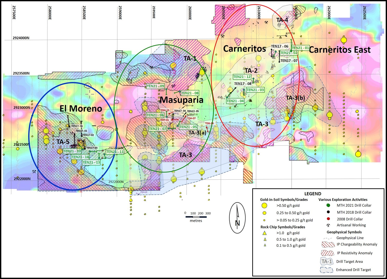
Figure 2 - LocationMap, El Moreno Area, Tenoriba Property Drilling, 2022 (drill holes TEN21-10, 11, 13 and 14)
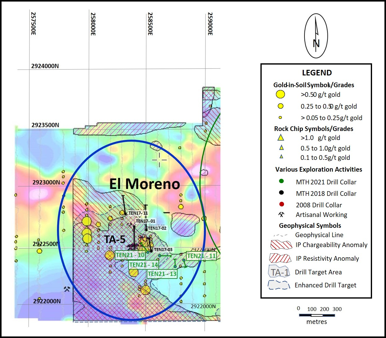
Copyright (c) 2022 TheNewswire - All rights reserved.