NCM:CC - Newcrest Mining Limited - Quarterly Exploration Report - 31 March 2023
Exploration portfolio continues to deliver on growth strategy
Melbourne, Australia--(Newsfile Corp. - April 26, 2023) - Newcrest (ASX: NCM) (TSX: NCM) (PNGX: NCM) continues to deliver on its global exploration growth strategy to identify Tier 1 mineral deposits which have the potential to provide long term operations in emerging copper-gold provinces.
At Red Chris, the application of our mining capabilities and a willingness to explore deeper have unlocked a significant mineral endowment and opportunity in an emerging world-class copper-gold province. In March 2023, Newcrest significantly enhanced the Exploration Target for East Ridge, confirming the substantial discovery near existing infrastructure and indicating potential to support additional block caves.
The Exploration Target defined for East Ridge (previously released) has been enhanced to between approximately 400Mt @ 0.42g/t Au & 0.49% Cu for 5.4Moz Au & 1.9Mt Cu and approximately 500Mt @ 0.39g/t Au & 0.47% Cu for 6.1Moz Au & 2.3Mt Cu. This is a significant enhancement compared to the East Ridge Exploration Target as at 30 June 20221. The Exploration Target is exclusive of the current published Mineral Resource and relates to the portion of the deposit that has not yet been adequately drill tested. The potential quantity and grade of the Exploration Target is conceptual in nature. There has been insufficient exploration to estimate a Mineral Resource and it is uncertain if further exploration will result in the estimation of a Mineral Resource.
Ongoing drilling east of the East Ridge Exploration Target returned a significant higher grade intercept with RC860 returning 66m @ 0.53g/t Au & 0.46% Cu from 1,332m including 32m @ 0.85g/t Au & 0.63% Cu from 1,342m, including 16m @ 1.1g/t Au & 0.74% Cu from 1,352m. This intersection demonstrates the potential to define further higher grade discoveries within the Red Chris porphyry corridor.
Target generation applying the knowledge gained from the Red Chris discoveries has identified an initial portfolio of seven high priority porphyry copper-gold targets across the 750km2 of claims which demonstrates the prospectivity of this region. A program of geological mapping, geochemical sampling and drilling is planned to commence in the September 2023 quarter.
At Brucejack, recent exploration (Pretium and Newcrest) has successfully expanded the footprint of the Valley of the Kings (VOK) deposit with the discovery of the North Block (pre-Newcrest) and 1080 HBx zones. These zones demonstrate the potential for new mining fronts within the footprint of the existing infrastructure. The VOK deposit continues to remain open in all directions and exploration drilling continues to test for new mineralised corridors. In addition, the upcoming VOK Deeps drill program is planned to test potential extensions of the deposit to depth.
- In the 1080 HBx Zone drilling continues to expand the footprint of the mineralisation (140m x 300m x 250m) and remains open outside the current Pretium published Mineral Resource, demonstrating the potential for resource growth at the VOK deposit. Results from this quarter include, VU-4749 returning 18m @ 306g/t Au from 261m, including 1m @ 5,370g/t Au from 266m.
- With our increased understanding of the Brucejack mineralised system, target generation applying the knowledge gained from North Block and the 1080 HBx Zone has identified several new opportunities within the 4km epithermal gold corridor from VOK to Golden Marmot. A surface drilling program is planned to assess these targets and de-risk future underground exploration development.
In Nevada, at the Spring Peak low sulfidation epithermal project, new drill results from the Disco zone have extended the continuity of the higher-grade veins and mineralised envelope up dip from the previously announced SP22-13^^2 (34.72m @ 2.7g/t Au from 256.12m, including, 2.01m @ 10g/t Au from 262.46m, 2.38m @ 16g/t Au from 275.26m, including 0.34m @ 70g/t Au from 275.96m). New results include:
SP22-11 returned 40.63m @ 1.9g/t Au from 185.38m including 0.79m @ 7.4g/t Au from 197.39m and 0.58m @ 44g/t Au from 208.33m and SP22-12 returned 42.61m @ 0.94g/t Au from 205.59m including 0.33m @ 24g/t Au 211.96m and 1.65m @ 4.3g/t Au from 235.18m.
RC pre-collar (SP22-10 RC) drilled 150m to the north-east of the existing Disco zone section returned 36.58m @ 0.53g/t Au from 161.54m, extending the strike continuity of the Disco structure. A diamond tail of this pre-collar will occur in the 2023 program.
In addition, further drilling has been successful in identifying a new high grade drill target at Opal Ridge.
- RC hole SP22-14 returned 10.67m @ 2.7g/t Au from 169.16m including 1.52m @16g/t Au from 170.69m.
Learnings from the successful extension of the Disco Zone and discovery of the Opal Ridge Zone will be applied to all of the Headwater Gold Joint Venture projects and planning is currently underway for the 2023 exploration program.
At Havieron, results from growth drilling in the prior period continue to demonstrate the potential for incremental resource additions around the Eastern Breccia, Northern Breccia and other higher grade mineralised pods.
Newcrest Interim Chief Executive Officer, Sherry Duhe, said, "We continue to unlock significant value for Newcrest across our global exploration portfolio consistent with our growth strategy. East Ridge represents a very exciting opportunity for Newcrest and we were pleased to enhance the Exploration Target in March 2023, providing additional future mining optionality at Red Chris. This asset is a great example of our track record in creating value through exploration success, and we continue to pursue further opportunities with an additional seven high priority drill targets identified across this highly prospective copper-gold region.
"At Brucejack, the drilling results further highlight the potential for brownfields growth in the Valley of the Kings mineralisation, with drilling demonstrating the potential for new mining fronts within the current mine area. We are starting to apply our learnings across the mineralised corridor, with a drilling program planned in the coming months to explore new zones of mineralisation.
"Our Greenfields exploration strategy remains on track with positive results at the Spring Peak project during the quarter, and ongoing drilling at Havieron continuing to demonstrate the potential for resource growth," said Ms Duhe.
Red Chris, British Columbia, Canada(3)
Red Chris is a joint venture between Newcrest (70%) and Imperial Metals Corporation (30%) and is operated by Newcrest.
The Brownfield Exploration program is focused on the discovery of additional zones of higher-grade mineralisation within the Red Chris porphyry corridor, including targets outside of Newcrest's Mineral Resource estimate. During the quarter, there were up to four diamond drill rigs in operation. A further 10,532m of drilling has been completed during the quarter from 10 drill holes, with all drill holes intersecting mineralisation. This contributed to a total of 310,685m of drilling from 301 drill holes since Newcrest acquired its interest in the joint venture in August 2019.
At East Ridge, located adjacent to the East Zone, drilling is ongoing with 81 holes completed and 5 in progress. Assay results were received for 5 holes during the quarter. The follow up drilling is being undertaken on a nominal 100m x 100m grid to determine the footprint, understand the mineralisation, geotechnical and geometallurgical characteristics and to determine the extent of continuity of the higher-grade mineralisation. Drilling to date has tested a corridor 1,000m long, 450m wide and to a vertical extent of 1,000m where zones of higher grade mineralisation have been identified. Mineralisation remains open at depth.
An updated Exploration Target has been estimated for East Ridge (previously reported), with ranges from a lower case of approximately 400Mt @ 0.42g/t Au & 0.49% Cu for 5.4Moz Au & 1.9Mt Cu to an upper case of approximately 500Mt @ 0.39g/t Au & 0.47% Cu for 6.1Moz Au & 2.3Mt Cu. This represents a significant enhancement in the size of the Exploration Target as at 6 March 2023 in comparison with the East Ridge Exploration Target as at 30 June 2022 which was estimated to have a lower case of approximately 170Mt @ 0.5g/t Au & 0.5% Cu for 2.8Moz Au & 0.9Mt Cu and an upper case of approximately 300Mt @ 0.4g/t Au & 0.4% Cu for 4.3Moz Au & 1.3Mt Cu.
The grades and tonnages are estimates based on continuity of mineralisation defined by exploration diamond drilling results (previously reported including relevant sections and plans) within the Redstock Intrusive with the lower range estimate in the area with a nominal drill hole spacing of 100m x 100m and the upper range estimate extended into the area with a nominal drill hole spacing of 100m x 200m.
East Ridge is outside of Newcrest's published Red Chris Mineral Resource estimate. Diamond drilling continues to define the extent and continuity of this higher grade mineralisation. At least 5 additional diamond drill holes are planned to test and close out the Exploration Target and determine geotechnical and metallurgical characteristics. This drilling program is expected to be completed by the second quarter of calendar year 2023. Work will be undertaken to deliver an updated Red Chris Mineral Resource estimate including East Ridge in calendar year 20234.
Drilling continues to confirm the vertical extent of the mineralisation within the Exploration Target. Drilling has returned a further deep significant higher-grade intercept with RC865 (located 100m east of RC857, previously reported) intersecting 132m @ 0.29g/t Au & 0.45% Cu from 1,552m,106m @ 0.57g/t Au & 0.57% Cu from 1,716m including 30m @ 0.95g/t Au & 0.87% Cu from 1,730m. These results confirm the vertical extent of the higher grade mineralisation, which remains open at depth and demonstrates further support of the upside range of the Exploration Target.
Ongoing drilling east of the East Ridge Exploration Target returned a significant higher grade intercept with RC860 returning 66m @ 0.53g/t Au & 0.46% Cu from 1,332m including 32m @ 0.85g/t Au & 0.63% Cu from 1,342m, including 16m @ 1.1g/t Au & 0.74% Cu from 1,352m. This intersection located approximately 100m east of the Exploration Target, demonstrates the potential to define further discoveries beyond East Ridge.
Target generation applying the knowledge gained from the Red Chris discoveries has identified an initial portfolio of seven high priority porphyry copper-gold targets across the 750km2 of mineral claims which demonstrates the prospectivity of this region. A program of geological mapping, geochemical sampling and drilling is planned for this summer field season.
Priority targets include:
- Far West (& Gully Zone) - Located immediately west of the Red Chris Main Zone, the prospect is defined by open higher grade copper-gold porphyry intercepts in historic shallow drilling.
- GJ-Donnelly - Previous Exploration has defined a 10km long corridor of porphyry mineralisation which contains localised higher grade copper-gold porphyry intercepts. There is potential to expand the mineralisation and discover additional zones of higher grade.
- QC Zone - A 5km long zone of porphyry-style alteration, veining and associated geochemistry along strike from Newmont's Saddle North resource. Historic shallow drilling at QC East intersected anomalous copper and gold mineralisation associated with porphyry-style alteration and veining.
- McBride - A 2km long zone of anomalous copper in surface rock chip samples with coincident magnetic high and Induced Polarisation chargeability anomalies. The prospect is located approximately 15km north of the Red Chris mine and is untested by drilling.
- Whiterock Canyon - A 1.5km x 1km area with porphyry style alteration and coincident anomalous surface rock chip geochemistry along the western extension to the Red Chris porphyry corridor directly along strike from the Gully Zone and Far West prospects. There is no previous drilling at this prospect.
- West Whiterock Creek - A prospect defined by anomalous surface rock chip geochemistry with coincident magnetic high anomalies that displays similarities with the Red Chris porphyry deposit, including the presence of gold-bearing early quartz veins and strong hydrothermal alteration. There is no previous drilling at this prospect.
- North Powerline - A newly identified early-stage porphyry copper-gold prospect defined by anomalous gold in surface geochemistry in rock chip samples and hydrothermal alteration in geological mapping. Anomalism appears to be associated with porphyry intrusive rocks with coincident with a magnetic high anomaly.
Approximately 10,000m of growth-related drilling targeting mineralisation definition and continuity is planned for the June 2023 quarter from up to four drill rigs.
Refer to Appendix 1 for additional information, and the drill hole data table for all results reported during the period.
Figure 1. Schematic plan view map of the Red Chris porphyry corridor spanning East Ridge, East Zone, Main Zone and Gully Zone showing significant Newcrest intercepts (drill intercepts have been reported in Appendix 2 of this report), 0.3g/t Au, 1g/t Au, 0.3% Cu and 1% Cu shell projections generated from a LeapfrogTM model.
To view an enhanced version of this graphic, please visit:
https://images.newsfilecorp.com/files/7614/163908_a50f66b1f4346851_003full.jpg
Figure 2. Long section view (looking North West) of the Red Chris porphyry corridor showing drill hole locations, gold distribution and Exploration Target (previously released).
To view an enhanced version of this graphic, please visit:
https://images.newsfilecorp.com/files/7614/163908_a50f66b1f4346851_004full.jpg
Figure 3. Schematic plan view map of the Red Chris porphyry Cu-Au district spanning the Red Chris, Mc Bride, GJ and QC porphyry corridors showing portfolio of targets.
To view an enhanced version of this graphic, please visit:
https://images.newsfilecorp.com/files/7614/163908_a50f66b1f4346851_005full.jpg
Brucejack, British Columbia, Canada(5)
The Brucejack Property hosts the Valley of the Kings (VOK) high-grade gold deposit. The VOK is characterised by multiple occurrences of higher grade mineralisation over selected intervals hosted within broader zones of stockwork and vein arrays. Growth activities are focused on both resource expansion within the existing mine area, as well as brownfields exploration activities within 4km of the mine area.
Resource expansion drilling during the quarter was focused on targets in Eastern Promises, Bridge Zone North, and West VOK. A total of 15,137m in 60 drill holes was completed using three underground diamond drill rigs. Assay results were received for two drill fans in Eastern Promises and two drill fans completed in the previous quarter in the 1080 HBx Zone. All other assays are pending.
At 1080 HBx Zone, assays were received for 20 drill holes (two drill fans). All drill holes intersected gold mineralisation, with 7 of the 20 drill holes intersecting higher grade mineralisation, in excess of 5 grams per tonne. Drilling continues to expand the existing footprint of the mineralisation (140m x 300m x 250m). All drill results reported are outside the current Pretium published Mineral Resource, demonstrating the potential for resource growth at the Valley of the Kings (VOK) deposit. Results from this quarter include:
- VU-4749
- 18m @ 306g/t Au from 261m
- including 1m @ 5,370g/t Au from 266m
- VU-4824
- 25.5m @ 21g/t Au from 75m
- including 1.5m @ 331g/t Au from 94.5m
Drill holes VU-4823 and VU-4825 were extended by 250 meters and 120 meters respectively to test for new mineralised corridors to the south of the HBx Domain, with VU-4823 intersecting higher grade mineralisation from 480m.
- VU-4823
- 10.5m @ 5.6 g/t Au from 480m
- VU-4825
- 15m @ 35g/t Au from 244.5m
- including 1m @ 516g/t Au from 253m
Future drilling will be conducted from a new exploration platform on the 1020 level to test down dip.
At Eastern Promises, drilling has commenced and is ongoing to demonstrate continuity and expand high grade mineralisation to the east. A full summary will be provided in the June Quarter. Eastern Promises is located immediately east of the 1080 HBx Zone with the intersection of the Domain 20 mineralisation.
With our increased understanding of the Brucejack mineralised system, target generation applying the knowledge gained from North Block and the 1080 HBx Zone has identified several opportunities within the 4km epithermal gold corridor from VOK to Golden Marmot. A surface drilling program is planned to assess these targets and de-risk future underground exploration development.
Assessment of the regional targets outside of the Brucejack epithermal corridor is planned for this upcoming field season, which is expected to commence in the June 2023 quarter. Work will focus on the key priority target American Creek (located 20km south east of the mine) where previous exploration has outlined an 8km long epithermal gold corridor.
Approximately 20,000m of resource expansion drilling targeting mineralisation definition and continuity is planned for the June 2023 quarter from up to six drill rigs operating underground and four drill rigs operating on surface during.
Refer to Appendix 2 for additional information, and the drill hole data table for all results reported during the period.
Figure 4. Plan view map of the Brucejack Property, spanning the 4km gossanous trend from Golden Marmot and Hanging Glacier in the northwest to Bridge Zone in the southeast.
To view an enhanced version of this graphic, please visit:
https://images.newsfilecorp.com/files/7614/163908_a50f66b1f4346851_006full.jpg
Figure 5. Long section view (looking west) of the Brucejack Property. Refer to figure 4 for the location of the cross section. Viewing window is +/- 100 meters.
To view an enhanced version of this graphic, please visit:
https://images.newsfilecorp.com/files/7614/163908_a50f66b1f4346851_007full.jpg
Figure 6. Schematic plan view map of the Brucejack epithermal Au district spanning the Brucejack and American Creek epithermal trends.
To view an enhanced version of this graphic, please visit:
https://images.newsfilecorp.com/files/7614/163908_a50f66b1f4346851_008full.jpg
Western USA
Spring Peak Project, Nevada
In August 2022, Newcrest entered into four separate definitive option and earn-in agreements with Headwater Gold Inc. (Headwater Gold) and purchased a 9.9% equity interest in the company (previously reported). Newcrest has the option to acquire up to a 75% interest individually in each of the Agate Point, Midas North and Spring Peak Projects in Nevada and the Mahogany Project in Oregon.
The Spring Peak project is located approximately 35km southwest of Hawthorn, Nevada in the Aurora mining district. In 2022 Headwater Gold completed a total of 3,170m drilled in 10 holes across the project area including both RC pre-collar with diamond tails and three RC only holes. During the quarter, all outstanding assays from the 2022 drill program were received which identified additional high-grade mineralisation at the Disco zone and the new high-grade Opal Ridge zone.
Exploration to date has defined a low sulfidation epithermal system over an interpreted area of 2.5km x 1.5km. Surface indications include high level sinters and veinlets associated with multiple structures. Initial work has focused on the Disco Zone.
Figure 7. Plan view of the Spring Peak project illustrating the location of the Disco Zone, Opal Ridge, drilling, and drill constrained cross sections. Coordinates are NAD83 UTM Zone 11 north.
To view an enhanced version of this graphic, please visit:
https://images.newsfilecorp.com/files/7614/163908_a50f66b1f4346851_009full.jpg
New drill results from the Disco zone have extended the continuity of the higher-grade veins and mineralised envelope up dip from the previously announced SP22-13^^ (34.72m @ 2.7g/t Au from 256.12m, including, 2.01m @ 10g/t Au from 262.46m, 2.38m @ 16g/t Au from 275.26m, including 0.34m @ 70g/t Au from 275.96m).
SP22-11 returned 40.63m @ 1.9g/t Au from 185.38m including 0.79m @ 7.4g/t Au from 197.39m and 0.58m @ 44g/t Au from 208.33m and SP22-12 returned 42.61m @ 0.94g/t Au from 205.59m including 0.33m @ 24g/t Au 211.96m and 1.65m @ 4.3g/t Au from 235.18m and SP22-07 returned 14.78m @ 0.93g/t Au from 175.87m. Diamond drill hole SP22-11 is a twin of RC drill hole SP21-03 and has increased both the thickness and grade of the RC intersection.
The Disco Zone occupies the footwall margin of a northeast-striking fault zone that is oriented similarly to vein trends at the adjacent past-producing Aurora mine complex (historic production estimated at 2.2Moz Au @ 10g/t Au6). Within the Disco Zone, holes SP22-07, SP22-11, SP22-12 and SP22-13 intersected multiple discrete veins with textures indicative of boiling, including ginguro banding, silica replacement of lattice bladed calcite and vein sediment.
The four holes that intersected the target structure were drilled on a single fence with mineralisation open down-dip and along strike. Early indications from drill data suggest that as per other epithermal systems globally the Disco zone demonstrates increasing grade with depth.
RC pre-collar (SP22-10 RC) drilled 150m to the north-east of the existing Disco zone section returned 36.58m @ 0.53g/t Au from 161.54m, extending the strike continuity of the Disco structure. A diamond tail of this pre-collar will occur in the 2023 program.
In addition, further drilling has been successful in identifying a new high grade drill target at Opal Ridge located 900m west of the Disco zone and is characterised by banded quartz vein material and fine-grained sulphide stringers. RC hole SP22-14 returned 10.67m @ 2.7g/t Au from 169.16m including 1.52m @ 16g/t Au from 170.69m.
Learnings from the successful extension of the Disco Zone and discovery of the Opal Ridge Zone will be applied to all of the Headwater Gold Joint Venture projects and planning is currently underway for the 2023 exploration program.
Refer to Appendix 3 for additional information and drill hole data table for all results reported during the period.
Figure 8. Geological and geophysical cross section of the Disco Zone with drill results from SP22-07, SP22-11, SP22-12 and SP22-13* (previously reported in Newcrest December 2022 Exploration Quarterly dated 25 January 2023*) illustrating the continuity of the mineralised envelope and the high-grade veins. The structure is open both down dip and along strike. A drill program to further test the zone is currently being planned. Section view is to the southwest.
To view an enhanced version of this graphic, please visit:
https://images.newsfilecorp.com/files/7614/163908_a50f66b1f4346851_010full.jpg
Figure 9. Geological cross section of the Opal Ridge Target with results from SP22-14. Drillhole LDH-3* drilled by Labradex in 1983 and historic assay data compiled and released by Headwater Gold (2 March 2023*). Section view is to the northwest.
To view an enhanced version of this graphic, please visit:
https://images.newsfilecorp.com/files/7614/163908_a50f66b1f4346851_011full.jpg
Figure 10. Geological and geophysical cross section illustrating the broad zone of hanging wall mineralisation intersected in RC precollar SP22-10 and its position relative the projected location of the disco zone structure. Section view is to the southwest.
To view an enhanced version of this graphic, please visit:
https://images.newsfilecorp.com/files/7614/163908_a50f66b1f4346851_012full.jpg
Havieron Project, Western Australia, Australia(7)
The Havieron Project is operated by Newcrest under a Joint Venture Agreement (JVA) with Greatland Gold Plc (Greatland). Newcrest is the manager and holds a 70% interest in the Havieron Project (Greatland holds a 30% interest). The JVA includes tolling principles reflecting the intention of the parties that, subject to a successful exploration program, Feasibility Study and a positive decision to mine, the resulting joint venture mineralised material will be processed at Telfer.
The Havieron Project is centred on a deep magnetic anomaly located 45km east of Telfer in the Paterson Province. The deposit is overlain by more than 420m of post mineral Permian cover. The Joint Venture commenced drilling during the June 2019 quarter and has completed 298,428m of drilling from 335 drill holes to date (excluding holes in progress, abandoned holes, or drill holes which have not been sampled).
Drilling activities in the quarter have produced a further 9,764m of drilling from 8 holes with up to 3 drill rigs operating during the quarter. This includes 7 infill drillholes within the current Crescent Inferred Resource which are not included in this report. New assay results are reported from 8 drill holes (all were assays pending from the previous quarter). Of the reported holes, 3 holes returned significant assay intercepts in excess of 50 gram metres gold (Au ppm x length m).
Growth drilling targeted resource additions outside of the existing Indicated and Inferred Mineral Resource limits and included:
- Extensions of the Eastern Breccia incorporating definition of identified internal higher-grade zones - assay results reported for 2 drill holes.
- Extensions to the Northern Breccia at depth between the current Northern Breccia Resource and Eastern Breccia Resource - assay results reported for 4 drill holes
- Drilling to assess geophysical targets outside of the main Havieron system - 2 drill hole results from step-out drilling to the northwest and southeast of the Havieron system.
The Eastern Breccia is developed below the 4,100RL with a footprint of over 500m in strike, up to 200m in width, and over 250m in vertical extent. Within this zone, multiple northwest trending internal higher-grade (>1 g/t Au) sulphide dominated domains are observed. HAD098W9 intersected 31.1m @ 4.9g/t Au & 0.13% Cu from 1,635m, including 10m @ 13g/t Au & 0.14 % Cu from 1,655m ~ 50m to the north west of the current Eastern Breccia Resource. HAD164W3 intersected 57m @ 2.1 g/t Au and 0.19% Cu from 1262 m, including 10m @ 8.5g/t Au & 0.29% Cu from 1307m ~200m vertically above the existing Eastern Breccia Mineral Resource.
Drilling in the Northern Breccia zone further highlights potential for incremental extensions to the Current Mineral Resource. Results include: HAD098W8, 22m @ 8.1g/t Au & 0.14% Cu from 1,287m, HAD098W9, 29.9m @ 3.9g/t Au & 0.01% Cu from 945.1m.
Drilling to test geophysical targets outside of the known Havieron mineralised system, including evaluating the Havieron system to along strike to the northwest and southeast, revealed no significant intercepts from two drill holes (HAD169 and HAD170).
The current campaign of growth programs for Havieron is now complete and will support ongoing resource assessment. Drilling is currently focussed on infill drilling on the lower SE Crescent zone with three rigs continuing into the June 2023 quarter.
Refer to Appendix 4 for additional information and drill hole data table for all results reported during the period.
Figure 11. 3D Plan view schematic showing the spatial association of the South East Crescent, Northern Breccia, North West Pod and Eastern Breccia in relation to the current exploration growth target areas and the Mineral Resource extents. Also highlighted are selected previously reported and new labelled intercepts >100 gram metres (Au ppm x length) that have been intersected outside of the Inferred Mineral Resource. Intercepts are projected to the 4600RL.
To view an enhanced version of this graphic, please visit:
https://images.newsfilecorp.com/files/7614/163908_a50f66b1f4346851_013full.jpg
Figure 12. 3D oblique view of the Havieron system viewed from the south-east, showing the position of high-grade intercepts (previously^^ reported and new labelled) and mineralised zones >100 gram metres (Au ppm x length) that have been intersected outside of the Mineral Resource extents. Further higher-grade mineralisation and assay results continue to support incremental expansion of the Northern Breccia and Southeast Crescent, as well as extensions to the Eastern Breccia (refer to Figure 5 for spatial relationship of drill holes and zones).
To view an enhanced version of this graphic, please visit:
https://images.newsfilecorp.com/files/7614/163908_a50f66b1f4346851_014full.jpg
Figure 13. Plan view schematic of a horizontal slice at 3900mRL through the Crescent Sulphide Zone and Breccia-hosted Zones, showing the extents of the 0.5 and 1.0 g/t Au LeapfrogTM grade shells with highlighted newly reported intercepts for this period. This diagram highlights >50 gram metres intersections drilled during the period, refer to inset diagram for relationship to all Havieron drilling.
To view an enhanced version of this graphic, please visit:
https://images.newsfilecorp.com/files/7614/163908_a50f66b1f4346851_015full.jpg
Western USA
Appaloosa Project, Nevada
In September 2022, Newcrest entered into an option and earn-in agreement (previously reported) with Gunpoint Exploration Ltd. (Gunpoint) to acquire up to 75% of the Appaloosa property located in Nevada, USA (with an option to acquire the remaining 25% of Appaloosa post the earn-in period). Appaloosa is an underexplored mineralised structural zone situated within Gunpoint's Talapoosa gold-silver project. During 2022, Newcrest undertook target definition work including mapping, geophysics, rock chip and channel sampling that defined multiple drill targets on the property. In January 2023, Newcrest provided notice to Gunpoint to enter into the Option Phase of the option and earn-in agreement at Appaloosa. During the quarter, a Notice of Intent (NOI) was lodged with the Bureau of Land Management (BLM) to undertake drill testing of multiple targets during the June 2023 quarter. Drill testing is planned to commence in April 2023.
Australia
Wilki Project, Western Australia
The Wilki Project is an exploration farm-in and joint venture with Antipa Minerals Limited (Antipa). The project area covers a strategic landholding of ~1,470km2 (post the return of certain tenements to Antipa during the quarter in exchange for a royalty) surrounding the Telfer operation and is adjacent to the Havieron Project. Newcrest entered into this exploration farm-in and joint venture agreement with Antipa in March 2020. Newcrest currently also has a 9.9% shareholding in Antipa.
As previously highlighted, Newcrest has elected to proceed to the next stage (Stage 1) of the farm-in agreement following completion of the initial exploration expenditure commitment (A$6 million). Newcrest has the potential to earn a 51% joint venture interest in the Wilki Project through expenditure of a further A$10 million by March 2025 during Stage 1. As of 1 July 2022, Newcrest is the manager and operator of the Wilki Project.
Field activities were suspended for the summer period and will resume in the first half of calendar year 2023, with planned soil sampling and follow up drilling to be completed, subject to successful attainment of heritage clearances.
Juri Joint Venture, Western Australia
The Juri Joint Venture is a farm-in and joint venture agreement with Greatland with respect to the Black Hills and Paterson Range East projects, located within the Paterson Province approximately 50km from the Telfer operation and in proximity to the Havieron Project. The joint venture covers an area of approximately 248km2. Newcrest currently has a 51% interest in the Juri Joint Venture, and the Joint Venture is currently managed by Greatland. Under the terms of the agreement, Newcrest has the potential to earn an additional 24% joint venture interest through expenditure of a further A$17 million by October 2024.
Field activities remained suspended during the summer period with ongoing target generation and project review activities conducted.
Mount Coolon Project, Queensland
In October 2022, Newcrest entered into a farm-in agreement with GBM Resources Ltd (GBM) in relation to the Mount Coolon Project to advance gold exploration in the Drummond Basin in Queensland. The agreement provides the potential for Newcrest to acquire up to a 75% interest in the Mount Coolon Project tenements by spending A$25M and completing a series of exploration milestones in a 3 stage farm-in over six years.
Newcrest considers the Drummond Basin to be highly prospective for discovery of new higher grade gold resources related to known epithermal gold deposits within the Mount Coolon Project area. The project is undergoing establishment activities, and initial targeting has identified a number of high priority targets below and along strike to previously identified gold-bearing low-sulphidation epithermal veining.
Project establishment activities have commenced, with initial preparation of reconnaissance and support programs undertaken during the quarter. Ground geophysical surveys, surface geochemical sampling and review of historic exploration areas will commence in the field from April 2023.
Northern Andes
Gamora Project, Ecuador
A second phase of scout drilling commenced at the Gamora Project, located in southeast Ecuador. This work is being conducted by Newcrest as the operator under an earn-in agreement with Lundin Gold Inc. (Lundin Gold) pursuant to which Newcrest can earn up to a 50% interest in eight exploration concessions. The concession areas cover strategic landholdings to the north and south of Lundin Gold's Fruta del Norte mining operation.
The current phase of diamond core drilling at Gamora is focused on testing priority copper-gold targets in the Mirador copper porphyry district. The program is planned to finish in the June 2023 quarter.
Appendix 1
Red Chris (70% Newcrest): JORC Table 1
Section 1: Sampling Techniques and Data
| Criteria |
| Commentary |
| Mineral tenement and land tenure status |
| Red Chris (including the GJ Property) comprises 204 mineral claims including five mining leases and is a joint venture between subsidiaries of Newcrest Mining Limited (70%) and Imperial Metals Corporation (30%). Newcrest Red Chris Mining Limited is the operator of Red Chris. In June 2022, Newcrest closed the acquisition of four early stage exploration properties from Hawkeye Gold & Diamond. The Todagin, McBride and Railway properties are expected to be added to the Red Chris Joint Venture. Newcrest Red Chris Mining Limited and the Tahltan Nation (as represented by the Tahltan Central Government, the Tahltan Band and Iskut First Nation) signed an amended and restated updated Impact, Benefit and Co-Management Agreement (IBCA) covering Red Chris on 15 August 2019. All obligations with respect to legislative requirements including minimum expenditure are maintained in good standing. |
| Exploration done by other parties |
| Conwest Exploration Limited, Great Plains Development Co. of Canada, Silver Standard Mines Ltd, Texasgulf Canada Ltd. (formerly Ecstall Mining Limited), American Bullion Minerals Ltd and bcMetals Corporation conducted exploration in the areas between 1956 and 2006. Imperial Metals Corporation acquired the project in 2007 and completed deeper drilling at the East and Main Zones between 2007 and 2012. |
| Geology |
| The Red Chris Project is located in the Stikine terrane of north-western British Columbia, 80 km south of the town of Dease Lake. Late Triassic sedimentary and volcanic rocks of the Stuhini Group host a series of Late Triassic to Early Jurassic (204?198 Ma) diorite to quartz monzonite stocks and dykes. Gold and copper mineralisation at Red Chris consists of vein, disseminated and breccia sulphide typical of porphyry-style mineralisation. Mineralisation is hosted by diorite to quartz monzonite stocks and dykes. The main mineral assemblage contains well developed pyrite-chalcopyrite-bornite sulphide mineral assemblages as vein and breccia infill, and disseminations. The main mineralisation event is associated with biotite and potassium feldspar-magnetite wall rock alteration. |
| Drill hole information |
| As provided. |
| Data aggregation methods |
| Significant assay intercepts are reported as (A) length-weighted averages exceeding 0.1g/t Au greater than or equal to 20m, with less than 10m of consecutive internal dilution; and (B) length-weighted averages exceeding 0.5g/t Au for greater than or equal to 10m, with less than 10m of consecutive internal dilution; and (C) length-weighted averages exceeding 1g/t Au for greater than or equal to 10m, with less than 10m of consecutive internal dilution; (D) length-weighted averages exceeding 5g/t Au greater than or equal to 10m, with less than 10m of consecutive internal dilution; and (E) length-weighted averages exceeding 10g/t Au for greater than or equal to 10m, with less than 10m of consecutive internal dilution. No top cuts are applied to intercept calculations. |
| Relationship between mineralisation widths and intercept lengths |
| Significant assay intervals reported represent apparent widths. Insufficient geological information is available to confirm the geological model and true width of significant assay intervals. |
| Diagrams |
| As provided. |
| Balanced reporting |
| This is the twenty-second release of Exploration Results for this project made by Newcrest. Exploration results have been reported by Newcrest since January 2020. Earlier reporting of exploration programs conducted by Newcrest and Imperial Metals Corporation have previously been reported. Exploration drilling programs are ongoing and further material results will be reported in subsequent Newcrest releases. |
| Other substantive exploration data |
| Nil. |
| Further work |
| Further drilling is planned to define the extents of the East Ridge, Main Zone and Gully Zone. |
Drillhole data(1)
Red Chris Project, British Columbia, Canada
Reporting Criteria: Intercepts reported are downhole drill width (not true width) Au >0.1ppm (0.1g/t Au) and minimum 20m downhole width with maximum consecutive internal dilution of 10m. Also highlighted are high grade intervals of Au >0.5ppm (0.5g/t Au), Au >1ppm (1g/t Au), Au > 5ppm (5g/t Au), Au >10ppm (10g/t Au) and minimum 10m downhole width with maximum consecutive internal dilution of 10m. Gold and copper grades are reported to two significant figures. Samples are from core drilling which is HQ or NQ in diameter. Core is photographed and logged by the geology team before being cut. Half core HQ and NQ samples are prepared for assay and the remaining material is retained in the core farm for future reference. Each assay batch is submitted with duplicates and standards to monitor laboratory quality. Total depth (end of hole) is rounded to one decimal place for reporting purposes.
| Hole ID |
| Hole Type |
| Easting (m) |
| Northing (m) |
| RL (m) |
| Total Depth (m) |
| Azimuth |
| Dip |
| From (m) |
| To (m) |
| Interval (m) |
| Au (ppm) |
| Cu (pct) |
| Cut off |
| Sampling techniques |
| Core samples are obtained from core drilling. NQ and HQ diameter diamond core was drilled on a 3m run. Whole core was sampled at 1.5m intervals except where visible gold was identified, in which case the sample length was shortened to 1.0 or 0.5m. |
| Drilling techniques |
| Core drilling was advanced with NQ and HQ diameter coring configuration. Core from select inclined drill holes are oriented on 3m runs using an electronic core orientation tool (Reflex ACTIII). At the end of each run, the bottom of hole position is marked by the driller, which is later transferred to the whole drill core run length with a bottom of hole reference line. |
| Drill sample recovery |
| Core recovery is systematically recorded from the commencement of coring to end of hole, by reconciling against driller's depth blocks in each core tray with data recorded in the database. Drillers depth blocks provided the depth, interval of core recovered, and interval of core drilled. Core recoveries were typically 100%, with isolated zones of lower recovery. |
| Logging |
| Geological logging recorded qualitative descriptions of lithology, alteration, mineralisation, veining, and structure (for all core drilled - 15,137m). Geotechnical measurements were recorded including Rock Quality Designation (RQD) fracture frequency, solid core recovery and qualitative rock strength measurements. All geological and geotechnical logging was conducted at the Brucejack Mine. Digital data logging was captured, validated and stored in an Acquire database. The Acquire database replaces the previous Geospark database. All drill cores were photographed, prior to sampling the core. |
| Sub-sampling techniques and sample preparation |
| Sampling, sample preparation and quality control protocols are considered appropriate for the material being sampled. Whole core NQ and HQ samples. Whole core samples were collected in plastic bags together with pre-numbered sample tags and grouped into shipping bins for dispatch to the laboratory by dedicated transport. Sample lengths were typically 1.5m, and weights typically varied from 11 to 15kg, with an average weight of approximately 12.5 Kg. Sample sizes are considered appropriate for the style of mineralisation. All drill core samples were freighted by road to the laboratory via hired transport. Sample preparation was conducted at the independent ISO 9001 certified and ISO 17025 accredited ALS Global preparation laboratories including Terrace. Kamloops, Yellowknife, and Vancouver. Samples were dried at 600C, and crushed to 90% passing 2 mm, and split to obtain up to 1 kg sub-sample, which was pulverised (using LM2) to produce a pulped product with the minimum standard of 85% passing 75?m. Duplicate sample data are available from crush and pulp samples at a rate of approximately 1:20. Duplicate results show an acceptable level of variability for the material sampled and style of mineralisation. |
| Quality of assay data and laboratory tests |
| Assaying of drill core samples was conducted at ALS in North Vancouver. All samples were assayed for 33 elements using a 4-acid digestion followed by ICP-OES determination (method ME-ICP61). Gold analyses were determined by 50g fire assay with atomic absorption finish (method Au-AA26; with trigger to Au-Gra22 50g gravimetric overlimit method at 18 ppm). Sampling and assaying quality control procedures consisted of inclusion of certified reference material (CRMs), coarse residue and pulp duplicates with each batch (at least 1:20). Assays of quality control samples were compared with reference samples in the Acquire SQL database and verified as acceptable prior to formal use of data from analysed batches. Laboratory quality duplicates including replicates and preparation duplicates are captured in the Acquire SQL database and assessed. Prepared pulp splits for mineralized samples were sent to MS Analytical Labs in Langley BC for secondary lab check work by comparable Au and ICP methods to ensure agreement with original results. Comparisons are acceptable. Analysis of the available quality control sample assay results indicates that an acceptable level of accuracy and precision has been achieved. The database contains no analytical data that has been numerically manipulated. The assaying techniques and quality control protocols used are considered appropriate for the data to be used for reporting exploration drilling results. |
| Verification of sampling and assaying |
| Sampling intervals defined by the geologist are electronically assigned sample identification numbers prior to core sampling. Corresponding sample numbers matching pre-labelled sample tags are assigned to each interval. All sampling and assay information were stored in a secure Acquire database with restricted access. Sample submission forms providing the sample identification number accompany each submission to the laboratory. Assay results from the laboratory with corresponding sample identification are loaded directly into the Acquire database. Assessment of reported significant assay intervals was verified by review of visible gold identified in the drill core and review of high resolution core photography. The verification of significant intersections has been completed by company personnel and the Competent Person/Qualified Person. No adjustments are made to assay data, and no twinned holes have been completed. Drilling intersects mineralisation at various angles. There are no currently known drilling, sampling, recovery, or other factors that could materially affect the accuracy or reliability of the data. |
| Location of data points |
| All collar coordinates are provided in the North American Datum (NAD83 Zone 9N). 1080 HBx and Eastern Promises: Underground drill collar locations are marked up by the survey department with spray paint, and a back site and foresight are provided to enable alignment; Drills are then aligned by the drill contractor based on the markup and sights, and a TN-14 collar Gyro is used to confirm orientation prior to drilling. Topographic control is established from 2014 Lidar. |
| Data spacing and distribution |
| 1080 HBx: Drill hole spacing is 15m laterally. Assays have been received for eight drill fans to date, and the zone will be included in the next Mineral Resource update for Brucejack, expected during the first half of the 2024 financial year. which is insufficient for estimation of a Mineral Resource. Eastern Promises: Drill hole spacing is 30m laterally. Assays have been received for two drill fans to date, which is insufficient for estimation of a Mineral Resource. No sample compositing is applied to samples. |
| Orientation of data in relation to geological structure |
| Drill holes at 1080 HBx are oriented towards 205 degrees in order to drill perpendicular to the broadly WNW-ESE oriented mineralization domains. Drilling intersected the HBX Domain, which is hosted in the Eastern Promises Porphyry unit. Drill holes at Eastern Prmises are oriented towards 190 and 165 degrees in order to drill perpendicular to the broadly ENE oriented mineralization domains. Drilling intersected Domain 20 and the HBX Domain, which are both hosted in the Eastern Promises Porphyry. |
| Sample security |
| The security of samples is ensured by tracking samples from drill rig to database and by using trusted transportation services, and third party laboratories with security protocols. Drill core was delivered from the drill rig to the Brucejack Core Facility. Geological and geotechnical logging, high resolution core photography and whole core sampling was undertaken at the Brucejack Core Facility. Sample numbers are obtained from pre-made sample tag books, first ensuring no duplication of sample ID's in the database. Sample tags are inserted into labelled plastic bags together with the sample, and the bagged sample secured with a zip tie. Samples were grouped in sequence into rice bags, then placed into dedicated sample shipment bins for transport offsite. Samples are transported by road to the preparation lab where transfer of custody occurs. Verification of sample numbers and identification is conducted by the laboratory on receipt of samples, and sample receipt advice issued to Newcrest. Details of all sample shipments are recorded in a shipment tracking table and require offsite removal forms prior to leaving the Brucejack site. Shipping dates, Hole IDs, sample ranges, and special instructions are recorded with the dispatch of samples to the laboratory analytical services. Receiving laboratories have a workorder template of methods and duplicates by which to process the samples unless otherwise specified. Any discrepancies noted during sample login at the laboratory are communicated and addressed. |
| Audits or reviews |
| Due to the limited duration of the program, no external audits or reviews have been undertaken. Internal verification and audit of Newcrest exploration procedures and databases are periodically undertaken. |
Section 2: Reporting of Exploration Results
| Criteria |
| Commentary |
| VU-4749 |
| DD |
| 426708 |
| 6257839 |
| 1088 |
| 438.2 |
| 205 |
| 37 |
| 230.0 |
| 241.5 |
| 11.5 |
| 1.3 |
| 1.0 |
| 261.0 |
| 279.0 |
| 18.0 |
| 306 |
| 1.0 |
| incl. |
| 266.0 |
| 267.0 |
| 1.0 |
| 5370 |
| 100 |
| 312.0 |
| 369.0 |
| 57.0 |
| 1.9 |
| 1.0 |
| 385.5 |
| 413.0 |
| 27.5 |
| 3.2 |
| 1.0 |
| 423.0 |
| 437.0 |
| 14.0 |
| 1.1 |
| 1.0 |
| VU-4750 |
| DD |
| 426708 |
| 6257839 |
| 1088 |
| 438.3 |
| 205 |
| 30 |
| 99.0 |
| 108.0 |
| 9.0 |
| 3.5 |
| 1.0 |
| 196.5 |
| 207.0 |
| 10.5 |
| 1.7 |
| 1.0 |
| 396.0 |
| 417.0 |
| 21.0 |
| 1.0 |
| 1.0 |
| VU-4751 |
| DD |
| 426708 |
| 6257839 |
| 1088 |
| 407.7 |
| 205 |
| 24 |
| 129.0 |
| 184.5 |
| 55.5 |
| 1.3 |
| 1.0 |
| 193.6 |
| 205.5 |
| 11.9 |
| 2.6 |
| 1.0 |
| VU-4752 |
| DD |
| 426708 |
| 6257839 |
| 1089 |
| 372.2 |
| 205 |
| 17 |
| 117.0 |
| 160.5 |
| 43.5 |
| 2.0 |
| 1.0 |
| VU-4753 |
| DD |
| 426708 |
| 6257839 |
| 1089 |
| 350.8 |
| 205 |
| 9 |
| 106.5 |
| 115.5 |
| 9.0 |
| 3.6 |
| 1.0 |
| 177.0 |
| 192.0 |
| 15.0 |
| 1.2 |
| 1.0 |
| VU-4754 |
| DD |
| 426708 |
| 6257839 |
| 1089 |
| 350.9 |
| 206 |
| -1 |
| 92.4 |
| 93.4 |
| 1.0 |
| 389 |
| 100 |
| 291.0 |
| 298.5 |
| 7.5 |
| 2.5 |
| 1.0 |
| VU-4755 |
| DD |
| 426708 |
| 6257839 |
| 1090 |
| 209.7 |
| 205 |
| -9 |
| 78.0 |
| 114.0 |
| 36.0 |
| 2.0 |
| 1.0 |
| VU-4756 |
| DD |
| 426708 |
| 6257839 |
| 1091 |
| 185.7 |
| 205 |
| -18 |
| 81.0 |
| 102.0 |
| 21.0 |
| 1.4 |
| 1.0 |
| VU-4757 |
| DD |
| 426708 |
| 6257839 |
| 1091 |
| 179.8 |
| 205 |
| -26 |
| no significant assays |
| VU-4758 |
| DD |
| 426708 |
| 6257839 |
| 1092 |
| 167.4 |
| 205 |
| -34 |
| 93.0 |
| 112.5 |
| 19.5 |
| 4.7 |
| 1.0 |
| 148.5 |
| 163.5 |
| 15.0 |
| 1.2 |
| 1.0 |
| VU-4759 |
| DD |
| 426708 |
| 6257839 |
| 1092 |
| 131.5 |
| 204 |
| -40 |
| no significant assays |
| VU-4822 |
| DD |
| 426845 |
| 6257848 |
| 1087 |
| 375 |
| 182 |
| 37 |
| 303.0 |
| 346.5 |
| 43.5 |
| 1.4 |
| 1.0 |
| VU-4823 |
| DD |
| 426845 |
| 6257847 |
| 1088 |
| 562.2 |
| 191 |
| 27 |
| 55.5 |
| 84.0 |
| 28.5 |
| 1.2 |
| 1.0 |
| 95.0 |
| 105.0 |
| 10.0 |
| 1.6 |
| 1.0 |
| 480.0 |
| 490.5 |
| 10.5 |
| 5.6 |
| 1.0 |
| VU-4824 |
| DD |
| 426845 |
| 6257847 |
| 1088 |
| 339 |
| 182 |
| 17 |
| 75.0 |
| 100.5 |
| 25.5 |
| 21 |
| 1.0 |
| incl. |
| 94.5 |
| 96.0 |
| 1.5 |
| 331 |
| 100 |
| 165.5 |
| 166.5 |
| 1.0 |
| 200 |
| 100 |
| VU-4825 |
| DD |
| 426845 |
| 6257847 |
| 1089 |
| 450.6 |
| 182 |
| 7 |
| 86.0 |
| 87.0 |
| 1.0 |
| 123 |
| 100 |
| 244.5 |
| 259.5 |
| 15.0 |
| 35 |
| 1.0 |
| incl. |
| 253.0 |
| 254.0 |
| 1.0 |
| 516 |
| 100 |
| 336.0 |
| 358.5 |
| 22.5 |
| 1.0 |
| 1.0 |
| VU-4826 |
| DD |
| 426845 |
| 6257848 |
| 1089 |
| 279 |
| 182 |
| -3 |
| 51.0 |
| 67.5 |
| 16.5 |
| 3.1 |
| 1.0 |
| VU-4827 |
| DD |
| 426845 |
| 6257848 |
| 1089 |
| 263.9 |
| 182 |
| -12 |
| 42.0 |
| 69.0 |
| 27.0 |
| 2.8 |
| 1.0 |
| VU-4828 |
| DD |
| 426845 |
| 6257848 |
| 1090 |
| 206.7 |
| 182 |
| -21 |
| 37.5 |
| 72.0 |
| 34.5 |
| 6.8 |
| 1.0 |
| incl. |
| 57.0 |
| 58.5 |
| 1.5 |
| 119 |
| 100 |
| VU-4829 |
| DD |
| 426845 |
| 6257848 |
| 1090 |
| 134.8 |
| 182 |
| -31 |
| no significant assays |
| VU-4830 |
| DD |
| 426845 |
| 6257848 |
| 1091 |
| 110.8 |
| 182 |
| -40 |
| no significant assays |
| VU-4965 |
| DD |
| 426912 |
| 6257940 |
| 1088 |
| 242.8 |
| 190 |
| 27 |
| 60.0 |
| 69.0 |
| 9.0 |
| 2.8 |
| 1.0 |
| VU-4966 |
| DD |
| 426912 |
| 6257940 |
| 1088 |
| 210 |
| 190 |
| 16 |
| 169.5 |
| 189.0 |
| 19.5 |
| 2.2 |
| 1.0 |
| VU-4967 |
| DD |
| 426912 |
| 6257940 |
| 1088 |
| 186.2 |
| 190 |
| 5 |
| no significant assays |
| 150.5 |
| 162.0 |
| 11.5 |
| 3.9 |
| 1.0 |
| VU-4968 |
| DD |
| 426912 |
| 6257940 |
| 1088 |
| 162 |
| 190 |
| -9 |
| VU-4969 |
| DD |
| 426912 |
| 6257940 |
| 1088 |
| 134.7 |
| 190 |
| -25 |
| 1.5 |
| 15.1 |
| 13.6 |
| 23 |
| 1.0 |
| incl. |
| 14.1 |
| 15.1 |
| 1.0 |
| 289 |
| 100 |
| VU-4970 |
| DD |
| 426912 |
| 6257940 |
| 1088 |
| 80.7 |
| 190 |
| -40 |
| no significant assays |
| VU-4999 |
| DD |
| 427025 |
| 6257979 |
| 1089 |
| 246.2 |
| 165 |
| 28 |
| no significant assays |
| VU-5000 |
| DD |
| 427025 |
| 6257979 |
| 1089 |
| 219 |
| 165 |
| 19 |
| no significant assays |
| VU-5001 |
| DD |
| 427025 |
| 6257979 |
| 1089 |
| 192.2 |
| 165 |
| 10 |
| no significant assays |
| VU-5002 |
| DD |
| 427025 |
| 6257979 |
| 1089 |
| 174.1 |
| 165 |
| -1 |
| no significant assays |
| VU-5003 |
| DD |
| 427025 |
| 6257979 |
| 1089 |
| 171 |
| 165 |
| -11 |
| no significant assays |
| VU-5004 |
| DD |
| 427025 |
| 6257979 |
| 1089 |
| 167.9 |
| 165 |
| -21 |
| no significant assays |
| VU-5005 |
| DD |
| 427025 |
| 6257979 |
| 1089 |
| 170.9 |
| 165 |
| -32 |
| no significant assays |
1 # drilling in progress, **partial intercept, assays pending. ^updated intercept ^^previously reported intercept
Figure 20. Plan view of the 1080 Level in the VOK, showing Domain 13, Domain 20, and the newly defined HBX Domain. The previously published Pretium resource is outlined in red.
To view an enhanced version of this graphic, please visit:
https://images.newsfilecorp.com/files/7614/163908_a50f66b1f4346851_022full.jpg
Figure 21. Cross section for drill fan 1080_37_WLAT19_33 (location shown on Figure 20) showing all drill holes and significant intercepts. Due to window size (+/- 15m) and section orientation (270?) holes may appear on multiple sections.
To view an enhanced version of this graphic, please visit:
https://images.newsfilecorp.com/files/7614/163908_a50f66b1f4346851_023full.jpg
Figure 22. Cross section for drill fan 1080_37_ELAT17_41_L3 (location shown on Figure 20) showing all drill holes and significant intercepts. Due to window size (+/- 15m) and section orientation (270?) holes may appear on multiple sections.
To view an enhanced version of this graphic, please visit:
https://images.newsfilecorp.com/files/7614/163908_a50f66b1f4346851_024full.jpg
Figure 23. Cross section for drill fan 1080_43_L1 (as shown on Figure 20) showing all drill holes and significant intercepts. Due to window size (+/- 15m) and section orientation (270?) holes may appear on multiple sections.
To view an enhanced version of this graphic, please visit:
https://images.newsfilecorp.com/files/7614/163908_a50f66b1f4346851_025full.jpg
Appendix 3
Spring Peak (Headwater Gold Inc., Farm-In Agreement): JORC Table 1
Section 1: Sampling Techniques and Data
| Criteria |
| Commentary |
| Mineral tenement and land tenure status |
| Spring Peak comprises 359 unpatented lode mining claims. 327 claims staked by CP Holdings Corporation, U.S. subsidiary of Headwater Gold with 32 additional claims held by an underlier with an agreement in place whereby Headwater Gold can obtain a 100% interest. Newcrest has entered into an Exploration Farm-In Agreement with CP Holdings Corporation and Headwater Gold Inc., effective 15 August 2022, with Headwater Gold as the initial Manager of the Spring Peak project. Newcrest is currently in the Option Phase of the Farm-in Agreement. All obligations with respect to legislative requirements including minimum expenditure are maintained in good standing. |
| Exploration done by other parties |
| Labradex, Teck, Radius Gold, and OceanaGold conducted exploration in the area between 1980 and 2020. Headwater Gold acquired the Spring Peak Property in June, 2021 and drilled the first significant vein intercept in August of 2021. Previously drilling by Labradex and Teck took place between 1983 and 1989. No drilling took place at Spring Peak between 1990 and 2020. |
| Geology |
| The Spring Peak Project is located in the western part of the Basin and Range Province in west-central Nevada, U.S.A, 38 km southwest of the town of Hawthorne, NV. Gold mineralisation is associated with a low-sulfidation epithermal system within the Bodie Hills - Aurora Volcanic Field. Mineralization is hosted in high-angle quartz-calcite veins with extensive silica-adularia-illite alteration. Mineralized veins occur in both a Cretaceous granite stock and adjacent package of Jurassic metavolcanic rocks into which the granite stock has been emplaced. |
| Drill hole information |
| As provided. |
| Data aggregation methods |
| Primary intervals are reported using 0.2 g/t Au cut off and 2.0 g/t Au for included intervals. |
| Relationship between mineralisation widths and intercept lengths |
| Significant assay intervals reported represent apparent widths. True thickness of the mineralised intervals are estimated to be between approximately 60% and 75% of downhole lengths. Internal dilution is less than 30% |
| Diagrams |
| As provided. |
| Balanced reporting |
| This is the second release of Exploration Results for this project made by Newcrest. Exploration drilling programs are ongoing and further material results will be reported in subsequent Newcrest releases. |
| Other substantive exploration data |
| Nil. |
| Further work |
| Planned follow up exploration commencing in July, 2023. |
Drillhole data(1)
Spring Peak, Nevada USA
Reporting Criteria: Intervals are reported as length-weighted averages using a cut-off of 0.2 g/t Au and a minimum length of 0.3m, with less than 30% total internal dilution. Also reported are intervals greater than 2.0g/t Au. Intervals below a cutoff of 0.2g/t Au were not reported as significant results. Gold grades are reported to two significant figures. Samples are from RC drilling and core drilling which is HQ in diameter. Core is photographed and logged by the geology team before being half- core sampled and sent for assay. Each assay batch is submitted with duplicates and standards to monitor laboratory quality.
| Sampling techniques |
| Core samples are obtained from core drilling in Proterozoic basement lithologies. PQ-HQ and NQ diameter core was drilled on a 6m run. Core was cut using an automated core-cutter and half core sampled at 1m intervals with breaks for major geological changes. Sampling intervals range from 0.2 - 2.0m. Cover sequences were not sampled. |
| Drilling techniques |
| Permian Paterson Formation cover sequence was drilled using mud rotary drilling. Depths of cover typically observed to approximately 420m vertically below surface. Steel casing was emplaced to secure the pre-collar. Core drilling was advanced from the base of the cover sequence with PQ3, HQ3 and NQ2 diameter coring configuration. Core from inclined drill holes is oriented on 3m and 6m runs using an electronic core orientation tool (Reflex ACTIII). At the end of each run, the bottom of hole position is marked by the driller, which is later transferred to the whole drill core run length with a bottom of hole reference line. |
| Drill sample recovery |
| Core recovery is systematically recorded from the commencement of coring to end of hole, by reconciling against driller's depth blocks in each core tray with data recorded in the database. Drillers depth blocks provided the depth, interval of core recovered, and interval of core drilled. Core recoveries were typically 100%, with isolated zones of lower recovery. Cover sequence drilling by the mud-rotary drilling did not yield recoverable samples. |
| Logging |
| Geological logging recorded qualitative descriptions of lithology, alteration, mineralisation, veining, and structure (for all core drilled - 8,835m for 8 drill holes, all intersecting mineralisation), including orientation of key geological features. Geotechnical measurements were recorded including Rock Quality Designation (RQD) fracture frequency, solid core recovery and qualitative rock strength measurements. Magnetic susceptibility measurements were recorded every metre. The bulk density of selected drill core intervals was determined at site on whole core samples. All geological and geotechnical logging was conducted at the Havieron site. Digital data logging was captured on diamond drill core intervals only, and all data validated and stored in an acQuire database. All drill cores were photographed, prior to cutting and/or sampling the core. The logging is of sufficient quality to support Mineral Resource estimates. |
| Sub-sampling techniques and sample preparation |
| Sampling, sample preparation and quality control protocols are considered appropriate for the material being sampled. Core was cut and sampled at the Havieron core processing facility. Half core samples of between 0.2 and 2.0 m were collected in pre-numbered calico bags and grouped in plastic bags for dispatch to the laboratory. Sample weights typically varied from 0.5 to 8kg. Sample sizes are considered appropriate for the style of mineralisation. Drill core samples were freighted by air and road to the laboratory. Sample preparation was conducted at the independent ISO17025 accredited Intertek Laboratory, Perth (Intertek). Samples were dried at 105oC, and crushed to 95% passing 4.75mm, and the split to obtain up to 3kg sub-sample, which was pulverised (using LM5) to produce a pulped product with the minimum standard of 95% passing 106?m. Routine grind size analysis is conducted. Duplicate samples were collected from crush and pulp samples at a rate of 1:20. Duplicate results show an acceptable level of variability for the material sampled and style of mineralisation. Periodic size checks (1:20) for crush and pulp samples and sample weights are provided by the laboratory and recorded in the acQuire database. |
| Quality of assay data and laboratory tests |
| Assaying of drill core samples was conducted at Intertek. All samples were assayed for 48 elements using a 4-acid digestion followed by ICP-AES/ICP-MS determination (method 4A/MS907), which is considered to provide a total assay for copper. Gold analyses were determined by 50g fire assay with AAS finish (method FA50N/AA), which is considered to provide a total assay for gold. Sampling and assaying quality control procedures consisted of inclusion of certified reference material (CRMs), coarse residue and pulp duplicates with each batch (at least 1:20). Assays of quality control samples were compared with reference samples in acQuire database and verified as acceptable prior to use of data from analysed batches. Laboratory quality control data, including laboratory standards, blanks, duplicates, repeats and grind size results are captured in the acQuire database and assessed for accuracy and precision for recent data. Extended quality control programs including pulp samples submitted to an umpire laboratory and combined with more extensive re-submission programs have been completed. Analysis of the available quality control sample assay results indicates that an acceptable level of accuracy and precision has been achieved and the database contains no analytical data that has been numerically manipulated. The assaying techniques and quality control protocols used are considered appropriate for the data to be used for reporting exploration drilling results. |
| Verification of sampling and assaying |
| Sampling intervals defined by the geologist are electronically assigned sample identification numbers prior to core cutting. Corresponding sample numbers matching pre-labelled calico bags are assigned to each interval. All sampling and assay information were stored in a secure acQuire database with restricted access. Electronically generated sample submission forms providing the sample identification number accompany each submission to the laboratory. Assay results from the laboratory with corresponding sample identification are loaded directly into the acQuire database. Assessment of reported significant assay intervals was verified by re-logging of diamond drill core intervals and assessment of high resolution core photography. The verification of significant intersections has been completed by company personnel and the Competent Person/Qualified Person. No adjustments are made to assay data, and no twinned holes have been completed. There are no currently known drilling, sampling, recovery, or other factors that could materially affect the accuracy or reliability of the data. |
| Location of data points |
| Drill collar locations were surveyed using a differential GPS with GNSS with a stated accuracy of +/- 0.5m for all drill holes reported. Drill rig alignment was attained using an electronic azimuth aligner. Downhole survey was collected at 6-12m intervals in the cover sequence, and every 6 to 30m in diamond drill core segments of the drill hole using single shot (Axis Mining Champ Gyro). The single shot surveys have been validated using continuous survey to surface (Axis Mining Champ) along with a selection of drill holes re-surveyed by an external survey contactor using a DeviGyro tool - confirming sufficient accuracy for downhole spatial recording. A LIDAR survey was completed over the project area in Nov 2019 which was used to prepare a DEM / topographic model for the project with a spatial accuracy of +/- 0.1m vertical and +/- 0.3m horizontal. The topography is generally low relief to flat, elevation within the dune corridors in ranges between 250-265m Australian Height Datum (AHD) steepening to the southeast. All collar coordinates are provided in the Geocentric Datum of Australian (GDA20 Zone 51). All relative depth information is reported in AHD +5000m. |
| Data spacing and distribution |
| Within the South-East Crescent and Breccia zone drill hole spacing ranges from 50 to 100m, to 50 by 50m within the resource extents. Outside the initial resource boundary drill hole spacing ranges from 50 to 200m in lateral extent within the breccia zone over an area of ~2km2. The data spacing is sufficient to establish the degree of geological and grade continuity. Significant assay intercepts remain open. Further drilling is required to determine the extent of currently defined mineralisation. No sample compositing is applied to samples. Drilling intersects mineralisation at various angles. |
| Orientation of data in relation to geological structure |
| Drill holes exploring the extents of the Havieron mineral system intersect moderately dipping carbonate and siliclastic sedimentary facies, mineralised breccia and sub-vertical intrusive lithologies. Geological modelling has been interpreted from historic and Newcrest drill holes. Variable brecciation, alteration and sulphide mineralisation is observed with a footprint with dimensions of 650m x 350m trending in a north west orientation and over 1000m in vertical extent below cover. The subvertical southeast high grade arcuate crescent sulphide zone has an average thickness of 20m and has been defined over a strike length of up to 550m, and extended to over 700m in vertical extent below cover. Drilling direction is oriented to intersect the steeply dipping high-grade sulphide mineralisation zones at an intersection angle of greater than 40 degrees. The drilled length of reported intersections is typically greater than true width of mineralisation. |
| Sample security |
| The security of samples is controlled by tracking samples from drill rig to database. Drill core was delivered from the drill rig to the Havieron core yard every shift. On completion of geological and geotechnical logging, core processing was completed by Newcrest personnel at the Havieron facility. High resolution core photography and cutting of drill core was undertaken at the Havieron core processing facilities. Samples were freighted in sealed bags by air and road to the Laboratory, and in the custody of Newcrest representatives. Sample numbers are generated directly from the database. All samples are collected in pre-numbered calico bags. Verification of sample numbers and identification is conducted by the laboratory on receipt of samples, and sample receipt advise issued to Newcrest. Details of all sample movement are recorded in a database table. Dates, Hole ID sample ranges, and the analytical suite requested are recorded with the dispatch of samples to analytical services. Any discrepancies logged at the receipt of samples into the analytical services are validated. |
| Audits or reviews |
| Internal reviews of core handling, sample preparation and assays laboratories were conducted on a regular basis by both project personnel and owner representatives. In the Competent Person's opinion, the sample preparation, security and analytical procedures are consistent with current industry standards and are entirely appropriate and acceptable for the styles of mineralisation identified and will be appropriate for use in the reporting of exploration results and Mineral Resource estimates. There are no identified drilling, sampling or recovery factors that materially impact the adequacy and reliability of the results of the drilling programme in place at the Havieron Project. |
Section 2: Reporting of Exploration Results
| Criteria |
| Commentary |
| Hole ID? |
| Hole Type |
| Easting (m) |
| Northing (m)? |
| RL (m)? |
| Total Depth (m)? |
| Azimuth? |
| Dip |
| From (m) |
| To (m) |
| Interval (m) |
| Au (ppm) |
| Cu (pct) |
| Cut off |
| HAD087W1 |
| MR-DD |
| 464338 |
| 7598259 |
| 5258 |
| 1603.1 |
| 222 |
| -70 |
| 1485 |
| 1505 |
| 20 |
| 0.67 |
| 0.04 |
| 0.2 g/t Au |
| HAD098W8 |
| MR-DD |
| 463591 |
| 7597381 |
| 5264 |
| 1540.1 |
| 38 |
| -61 |
| 771 |
| 814 |
| 43 |
| 0.28 |
| 0.03 |
| 0.2 g/t Au |
| HAD098W8 |
| 850 |
| 874 |
| 24 |
| 0.28 |
| 0.22 |
| 0.2 g/t Au |
| HAD098W8+ |
| 1011 |
| 1049 |
| 38 |
| 0.77 |
| 0.22 |
| 0.2 g/t Au |
| HAD098W8+ |
| 1063 |
| 1095 |
| 32 |
| 0.44 |
| 0.10 |
| 0.2 g/t Au |
| HAD098W8+ |
| 1110 |
| 1247 |
| 137 |
| 1.0 |
| 0.10 |
| 0.2 g/t Au |
| HAD098W8 |
| incl. |
| 1229 |
| 1231 |
| 2.0 |
| 45.0 |
| 0.26 |
| 30 g/t Au |
| HAD098W8 |
| 1287 |
| 1309 |
| 22 |
| 8.1 |
| 0.14 |
| 0.2 g/t Au |
| HAD098W8 |
| incl. |
| 1305 |
| 1307 |
| 2 |
| 71 |
| 0.22 |
| 30 g/t Au |
| HAD098W9 |
| MR-DD |
| 463591 |
| 7597381 |
| 5264 |
| 1666.1 |
| 38 |
| -61 |
| 786 |
| 836 |
| 50 |
| 0.66 |
| 0.11 |
| 0.2 g/t Au |
| HAD098W9 |
| incl. |
| 788 |
| 798 |
| 10 |
| 1.3 |
| 0.21 |
| 1.0 g/t Au |
| HAD098W9 |
| 945.1 |
| 975 |
| 29.9 |
| 3.9 |
| 0.01 |
| 0.2 g/t Au |
| HAD098W9 |
| 967 |
| 969 |
| 2 |
| 52 |
| 0.06 |
| 30 g/t Au |
| HAD098W9+ |
| 989 |
| 1027 |
| 38 |
| 0.84 |
| 0.09 |
| 0.2 g/t Au |
| HAD098W9+ |
| 1138 |
| 1210 |
| 72 |
| 0.29 |
| 0.16 |
| 0.2 g/t Au |
| HAD098W9 |
| 1635 |
| 1666.1 |
| 31.1 |
| 4.9 |
| 0.13 |
| 0.2 g/t Au |
| HAD098W9 |
| incl. |
| 1655 |
| 1665 |
| 10 |
| 13 |
| 0.14 |
| 1.0gt Au |
| HAD098W9 |
| incl. |
| 1661 |
| 1663 |
| 2 |
| 41 |
| 0.10 |
| 30 g/t Au |
| HAD133W10 |
| MR-DD |
| 464072 |
| 7598317 |
| 5257 |
| 1482.9 |
| 173 |
| -65 |
| Resource Infill Hole |
| HAD152W6 |
| MR-DD |
| 463401 |
| 7597059 |
| 5254 |
| 1845.8 |
| 33 |
| -64 |
| Assays Pending |
| HAD159W1 |
| MR-DD |
| 464077 |
| 7597252 |
| 5260 |
| 1621.3 |
| 34 |
| -62 |
| Resource Infill Hole |
| HAD161 |
| MR-DD |
| 463407 |
| 7597519 |
| 5263 |
| 1518.5 |
| 38 |
| -61 |
| 1018 |
| 1054 |
| 36 |
| 0.45 |
| 0.14 |
| 0.2 g/t Au |
| HAD161+ |
| 1134 |
| 1211 |
| 77 |
| 0.59 |
| 0.05 |
| 0.2 g/t Au |
| HAD161 |
| 1387 |
| 1433 |
| 46 |
| 0.44 |
| 0.12 |
| 0.2 g/t Au |
| HAD161W1 |
| MR-DD |
| 463407 |
| 7597519 |
| 5263 |
| 1618 |
| 38 |
| -61 |
| 1549 |
| 1595 |
| 46 |
| 0.43 |
| 0.04 |
| 0.2 g/t Au |
| HAD164W3 |
| MR-DD |
| 464444 |
| 7598227 |
| 5258 |
| 1738.3 |
| 220 |
| -79 |
| 1262 |
| 1319 |
| 57 |
| 2.1 |
| 0.19 |
| 0.2 g/t Au |
| HAD164W3 |
| incl. |
| 1284 |
| 1299 |
| 15 |
| 1.9 |
| 0.43 |
| 1.0 g/t Au |
| HAD164W3 |
| incl. |
| 1307 |
| 1317 |
| 10 |
| 8.5 |
| 0.29 |
| 1.0 g/t Au |
| HAD164W3 |
| 1438 |
| 1472 |
| 34 |
| 0.83 |
| 0.61 |
| 0.2 g/t Au |
| HAD164W3 |
| 1512 |
| 1555 |
| 43 |
| 0.25 |
| 0.00 |
| 0.2 g/t Au |
| HAD164W3 |
| 1567 |
| 1625 |
| 58 |
| 0.84 |
| 0.03 |
| 0.2 g/t Au |
| HAD164W3 |
| incl. |
| 1611 |
| 1621 |
| 10 |
| 3.5 |
| 0.06 |
| 1.0 g/t Au |
| HAD169 |
| MR-DD |
| 464308 |
| 7597211 |
| 5260 |
| 865 |
| 76 |
| -56 |
| No Significant Results |
| HAD170 |
| MR-DD |
| 463275 |
| 7598285 |
| 5254 |
| 780.7 |
| 60 |
| -60 |
| No Significant Results |
| HAD171 |
| MR-DD |
| 463672 |
| 7596940 |
| 5255 |
| 1809.6 |
| 26 |
| -62 |
| Resource Infill Hole |
| HAD171W1 |
| MR-DD |
| 463672 |
| 7596940 |
| 5255 |
| 1782.6 |
| 26 |
| -62 |
| Resource Infill Hole |
| HAD172 |
| MR-DD |
| 464463 |
| 7598018 |
| 5257 |
| 1543.2 |
| 217 |
| -72 |
| Resource Infill Hole |
| HAD172W1 |
| MR-DD |
| 464463 |
| 7598018 |
| 5257 |
| 1522 |
| 217 |
| -72 |
| Resource Infill Hole |
| HAD172W2 |
| MR-DD |
| 464463 |
| 7598018 |
| 5257 |
| 1560.1 |
| 217 |
| -72 |
| Resource Infill Hole |
1 # drilling in progress, **partial intercept, assays pending. ^updated intercept ^^previously reported intercept, +intercept within published resource
Figure 24. Schematic plan view map showing drill hole locations and significant intercepts reported in this release superimposed on the interpreted geology. Previously reported holes are not shown for the sake of clarity. Note some holes and results appear on multiple sections due to the sections orientation and sections overlap.
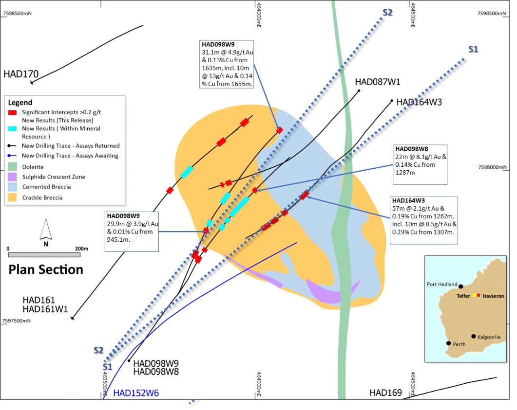
To view an enhanced version of this graphic, please visit:
https://images.newsfilecorp.com/files/7614/163908_a50f66b1f4346851_026full.jpg
Figure 25. Schematic cross section of geology and significant new drillhole intercepts (looking northwest, Section Line S1, +/-50m section width, as shown in Figure 24). Due to section window size and orientation holes may appear on multiple sections. This diagram highlights >50gram metres intersections drilled during the period. Reported drill holes are outside of the existing resource.
To view an enhanced version of this graphic, please visit:
https://images.newsfilecorp.com/files/7614/163908_a50f66b1f4346851_027full.jpg
Figure 26. Schematic cross section of geology and significant new drillhole intercepts (looking northwest, Section Line S2, +/-50m section width, as shown in Figure 24). Due to section window size and orientation holes may appear on multiple sections. This diagram highlights >50gram metres intersections drilled during the period. Reported drill holes are outside of the existing resource.
To view an enhanced version of this graphic, please visit:
https://images.newsfilecorp.com/files/7614/163908_a50f66b1f4346851_028full.jpg
Forward Looking Statements
This document includes forward looking statements and forward looking information within the meaning of securities laws of applicable jurisdictions. Forward looking statements can generally be identified by the use of words such as "may", "will", "expect", "intend", "plan", "estimate", "target", "anticipate", "believe", "continue", "objectives", "outlook" and "guidance", or other similar words and may include, without limitation, statements regarding estimated reserves and resources, internal rates of return, expansion, exploration and development activities and the specifications, targets, results, analyses, interpretations, benefits, costs and timing of them; certain plans, strategies, aspirations and objectives of management, anticipated production, sustainability initiatives, climate scenarios, dates for projects, reports, studies or construction, expected costs, cash flow or production outputs and anticipated productive lives of projects and mines. The Company continues to distinguish between outlook and guidance. Guidance statements relate to the current financial year. Outlook statements relate to years subsequent to the current financial year.
These forward looking statements involve known and unknown risks, uncertainties and other factors that may cause the Company's actual results, performance, and achievements to differ materially from any future results, performance or achievements, or industry results, expressed or implied by these forward looking statements. Relevant factors may include, but are not limited to, changes in commodity prices, foreign exchange fluctuations and general economic conditions, increased costs and demand for production inputs, the speculative nature of exploration and project development, including the risks of obtaining necessary licences and permits and diminishing quantities or grades of resources or reserves, political and social risks, changes to the regulatory framework within which the Company operates or may in the future operate, environmental conditions including extreme weather conditions, recruitment and retention of personnel, industrial relations issues and litigation. For further information as to the risks which may impact on the Company's results and performance, please see the risk factors discussed in the Operating and Financial Review included in the Appendix 4E and Financial Report for the year ended 30 June 2022 and the Annual Information Form dated 14 December 2022 which are available to view at www.asx.com.au under the code "NCM" and on Newcrest's SEDAR profile.
Forward looking statements are based on management's current expectations and reflect Newcrest's good faith assumptions, judgements, estimates and other information available as at the date of this report and/or the date of Newcrest's planning or scenario analysis processes as to the financial, market, regulatory and other relevant environments that will exist and affect Newcrest's business and operations in the future. Newcrest does not give any assurance that the assumptions will prove to be correct. There may be other factors that could cause actual results or events not to be as anticipated, and many events are beyond the reasonable control of Newcrest. Readers are cautioned not to place undue reliance on forward looking statements, particularly in the current economic climate with the significant volatility, uncertainty and disruption caused by global events such as geopolitical tensions and the ongoing COVID19 pandemic. Forward looking statements in this document speak only at the date of issue. Except as required by applicable laws or regulations, Newcrest does not undertake any obligation to publicly update or revise any of the forward looking statements or to advise of any change in assumptions on which any such statement is based.
Ore Reserves and Mineral Resources Reporting Requirements
As an Australian Company with securities listed on the Australian Securities Exchange (ASX), Newcrest is subject to Australian disclosure requirements and standards, including the requirements of the Corporations Act 2001 and the ASX. Investors should note that it is a requirement of the ASX Listing Rules that the reporting of Ore Reserves and Mineral Resources in Australia is in accordance with the 2012 Edition of the Australasian Code for Reporting of Exploration Results, Mineral Resources and Ore Reserves (the JORC Code) and that Newcrest's Ore Reserve and Mineral Resource estimates and reporting comply with the JORC Code.
Newcrest is also subject to certain Canadian disclosure requirements and standards, as a result of its secondary listing on the Toronto Stock Exchange (TSX), including the requirements of National Instrument 43-101 - Standards of Disclosure for Mineral Projects (NI 43-101). Investors should note that it is a requirement of Canadian securities law that the reporting of Mineral Reserves and Mineral Resources in Canada and the disclosure of scientific and technical information concerning a mineral project on a property material to Newcrest comply with NI 43-101.
Newcrest's material properties are currently Cadia, Lihir, Red Chris and Wafi-Golpu. Copies of the NI 43-101 Reports for Cadia, Lihir and Wafi-Golpu, which were released on 14 October 2020, and Red Chris, which was released on 30 November 2021, are available at www.newcrest.com and on Newcrest's SEDAR profile.
Competent Person's Statement
The information in this document that relates to Exploration Targets, Exploration Results, and related scientific and technical information, is based on and fairly represents information compiled by Mr F. MacCorquodale. Mr MacCorquodale is the General Manager - Greenfields Exploration and a full-time employee of Newcrest Mining Limited. He is a shareholder in Newcrest Mining Limited and is entitled to participate in Newcrest's executive equity long term incentive plan, details of which are included in Newcrest's 2022 Remuneration Report. He is a Member of the Australian Institute of Geoscientists. Mr MacCorquodale has sufficient experience which is relevant to the styles of mineralisation and types of deposits under consideration and to the activity which he is undertaking to qualify as a Competent Person as defined in the JORC Code and as a Qualified Person under NI 43-101. Mr MacCorquodale approves the disclosure of scientific and technical information contained in this document and consents to the inclusion of material of the matters based on his information in the form and context in which it appears.
Authorised by the Newcrest Disclosure Committee
For further information please contact
Investor Enquires
Tom Dixon
+61 3 9522 5570
+61 450 541 389
Tom.Dixon@newcrest.com.au
Rebecca Lay
+61 3 9522 5298
+61 438 355 511
Rebecca.Lay@newcrest.com.au
North American Investor Enquiries
Vlada Cvijetinovic
+1 604 335 9202
+1 604 240 2998
Vlada.Cvijetinovic@newcrest.com.au
Media Enquiries
Tim Salathiel
+61 3 9522 4263
+61 407 885 272
Tim.Salathiel@newcrest.com.au
This information is available on our website at www.newcrest.com.
1 The Exploration Target as at 30 June 2022 has been extracted from Newcrest's release titled "Quarterly Exploration Report" dated 21 July 2022 which is available at www.asx.com.au under the code "NCM" and on Newcrest's SEDAR profile.
2 # drilling in progress ** partial intercept, assays pending ^ updated intercept or ^^ previously reported.
3 # drilling in progress ** partial intercept, assays pending ^ updated intercept or ^^ previously reported.
4 Subject to market and operating conditions and no unforeseen delays.
5 # drilling in progress ** partial intercept, assays pending ^ updated intercept or ^^ previously reported.
6 Data on Aurora past production sourced from MinEx Consulting 2020 Global Deposit Database.
7 # drilling in progress ** partial intercept, assays pending ^ updated intercept or ^^ previously reported.
To view the source version of this press release, please visit https://www.newsfilecorp.com/release/163908