CRS:CC - Crestview Exploration Announces Results from the 2022 Geological Mapping at the Rock Creek Gold Prospect in Elko County Nevada
(TheNewswire)
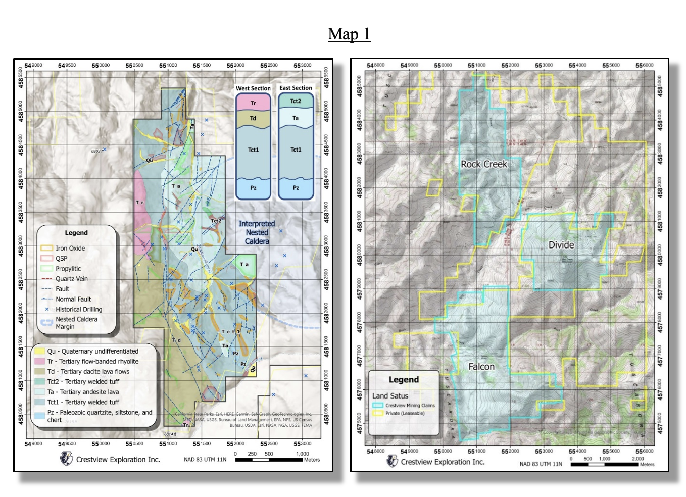
Calgary, Canada December 13, 2022 – TheNewswire - Crestview ExplorationInc. ( CSE: C RS ) , ( Frankfurt:CE7 ) (“Crestview” or “the Company”) is pleased toannounce the results from the 2022 mapping campaign at the Rock Creekgold prospect in the Tuscarora Mountains of Elko County, Nevada. Theseresults include the completion of the geology map and overlays,detailed descriptions of structures and mapped units, and alterationand mineralization observations and interpretations. A digitized andsimplified version of the geology map is attached below (Map 1).
The mapping project accomplished several key goals,including:
-
A base map of surface features to guide drill targetingand better understand geophysical results, by
-
Identifying and delineating the mineralized andunmineralized surface lithologies
-
Modelling the strength and distribution of alterationfeatures
-
An updated and more accurate model of veins andstructures controlling surface mineralization
The mapping project was completed at the 1:2,000 scale,producing five folios with three geological overlays (geology,alteration, and Fe oxides) that were used to generate the South,Central, West, North and North End interpretive folios. S cans of the original (hand-drawn) interpretive folios andfield progress reports will be available on the company website at www.crestviewexploration.com .
As a reminder to the reader, the Rock Creek propertyconsists of 74 unpatented lode mining claims, but is in closeproximity to (as near as currently possible) Crestview’s Divide andFalcon properties which comprise an additional 186 claims, for a totalof approximately 2,009 hectares or 4,965 acres between the three.Small historical prospecting occurred at all three properties, andmore extensive historic mining occurred at Falcon and Divide. At RockCreek, there was also some historic drilling which confirmed anomalousprecious metal values; however, none of these holes penetrated deeperthan 500 ft (Unpublished report by Cruson and Limbach, 1985).
The property is located within the Eocene BigCottonwood Canyon caldera in the Tuscarora volcanic field, hosting lowsulfidation epithermal quartz veins with precious metalmineralization. The Big Cottonwood Canyoncaldera complex consists of multiple episodes of rhyolitic ash-flowtuff and lava flows of andesitic to dacitic composition. The mappingat Rock Creek concurs with the geological views of Henry and Boden(1998) on the general evolution of the Big Cottonwood Canyon Caldera.
MAPPED ROCK UNITS
On the accompanying maps, the ash-flow tuff of BigCottonwood Canyon isbroken into an lower and upper unit (Tct1 andTct2), which are separated by a thin andesitic lava flow (Ta).Thelower ash-flow tuff unit (Tct1) is the main host for quartz veins atthe property. The unit is a weakly to moderately lithic, densely tomoderately welded ash-flow tuff with abundant fiamme. In alteredsamples, plagioclase and biotite are generally removed resulting inpitted textures. Lithic fragments are small (< 5 cms) angularpieces of Paleozoic quartzite/siltstone. Near the structures, itshydrothermally altered to quartz+sericte/illite in thin envelopesproducing linear color anomalies (white to gray bleaching). Silicified and breccia ledges are found inseveral locations.
Overlying this unit is an unaltered to propyliticaltered, dark to light greenish porphyriticplagioclase andesite lava flow (Ta). These andesites range fromhornblende to plagioclase dominant, with low content in biotite(<1%). This rock unit hosts two prospects sampled during mapping.In both localities, late comb veins and gray quartz stockworksveinlets abound. At the North end of the property, andesiticautobreccias, , are somewhat common within the andesite lava flows.
Outcropping in topographic highs in the central portionof the property, an upper ash-flow rhyolitic tuff unit with 5-7%coarse lithic fragments (Tct2) overlies the andesites. This may be anindication of near- vent facies and a smallnested caldera within the larger caldera. Sparse and small NE-trendingquartz veins cut the Tct2 tuffs.
Field observations suggest that the dacite lava flows(Td) along the southern and central borders of the Rock Creek propertyoverlie the lithic-rich ash-flow tuffs of Tct1. The dacite ismedium-grained with clear plagioclase phenocrysts (15%), scarce quartz(<1%), hornblende, and biotite (2%). The unit is weakly altered(propylitic) and oxidized, and the lava flows form smooth outcropswith typical reddish-purple colors in areas of low, rollingtopography. The dacitic domes and flows (Td) are hypothesized to havebeen emplaced after the eruption of the Tct2 ash-flow tuffs and thecollapse of the caldera. In the southern portion of Rock Creek, asuspected dacitic lava dome underlays the Tct1 ash-flow tuffs.
The last eruptive episode(s) is represented by a smalleruption(s) of rhyolitic lava(s) from several plugs (Tr), which mayhave occurred between 35 and 33 Ma based on nearby radiometric dating(Ar-Ar; Henry and Boden, 1998). The rhyolite is light- tan/pinkishcolored with a strong flow banding foliation. The Tr unit is weaklyaltered to propylitic-c assemblage (Hudson, 2003).
The oldest and deepest unit mapped at Rock Creek is thePaleozoic metasedimentary sequence (Pz), which is comprised ofintensely fractured and folded quartzite/quartzarenite, metasiltstone,and chert. The Pz unit was mapped in small, structurally controlledoutcrops in the southern portion of the property. The Pz rocks featureabundant Fe-oxides along fractures and quartz veins with late quartzvein stockworks.
STRUCTURES, ALTERATION AND QTZ VEINS
The faults and quartz veins delineate major structuraltrends of mineralization and alteration at Rock Creek. The quartzveins occur in several structural systems that dominate the entireRock Creek property. In the field, these structures can be traced fora few to a few hundred meters, with greater strike lengths interpretedfrom aerial imagery. Most of the structures/veins have well-developedslickensides with apparent normal and oblique slips. The width of thevein systems is variable, up to 140 meters.
The structural trends are NE (with a minor NNEcomponent), NS and NW -trending with moderate to high dips. Ingeneral, NE-trending faults are the younger structures, cutting NS andNW-trending structures. The oblique-slip movements of the primaryNNE-system may have caused the development of NS and NNWdilational/extensional fractures/veins between the primary fractures.Ta dikes may be aligned to the NE-trending fractures in the CentralFolio. Lastly, there is a discrete East-West fracture fabric that cutsall the former structures.
The fractured-controlled alteration envelopes at RockCreek are small, decreasing outward from the hanging-wall section ofthe main structures. In general, textures are preserved within thealteration envelopes. Three main alteration types have been identifiedwithin the mapping area, including silicification,quart+sericite/illite± pyrite (QSP), and propylitization.
Mineralized quartz veins are primarily hosted in thelower ash-flow tuff unit (Tct1) at Rock Creek. Quartz veins exhibitmultiple phases of growth and emplacement in faults, with frequentpost-mineral brecciation affecting both the host rocks and veins. Theveins have a sharp boundary with the host rock, with variable widthsranging from centimeter-scale up to ten meters. The quartz veintextures observed include crustiform, cockade, comb, and massive.Lattice quartz textures were observed in a few localities, indicatingshallow boiling and (probable) precious metals deposition. Late,cross-cutting stockwork quartz veinlets are a common feature in mostveins.
Quantitative data from fluid inclusions from quartzveins in the Tuscarora mining district (Castor et al., 2003; Henry etal., 1998) suggest shallow depths of vein formation (200 to 400meters), which agrees with the textures and alteration patternsobserved during field mapping.
The original pyrite content is estimated between one tothree percent. Late Fe-oxides (jarosite and hematite) and euhedralbarite fill cavities and late fractures.
Field mapping, aerial photo lineaments, and magneticanomalies suggest a nested caldera within the older Big CottonwoodCanyon caldera. The nested caldera is an oval structure having adiameter of about 3 km. Within the property, plagioclase andesiticflows (Ta) and the lithic-rich ash-flow tuff unit Tct2 were emplacedalong the western margins of the caldera. Aeromagnetic data showsthree magnetic highs toward the west margin of the nested caldera;these magnetic highs may be the result of stacked plagioclase andesiteflows, and the presence of andesitic intrusion(s) at depth.
A small siliceous, unmineralized sinter was mapped atthe north end of the property, near the intersection zone of a NE andN-striking structures.
CONCLUSIONS
The mapping at the Rock Creek property has revealed thepresence of low grade but laterally extensive precious metalsmineralization controlled by NNW, NS, and NNE-trending, high to lowangles faults and fractures. The mineralization is primarily hosted inthe intracaldera Tct1 ash-flow tuffs.
The interpretation that caldera ring fracture zones andcymoid loops had a major control on mineralization opens an additionalarea for further exploration in the nested caldera within theproperty.
A follow-up hyperspectral imaginary survey isrecommended at Rock Creek to delineate alteration zonation of claysand carbonates and the orientation of potential ore-bearingstructures.
REFERENCES
Castor, S., et al., 2003. TheTuscarora Au-Ag District: Eocene Volcanic-Hosted Epithermal Depositsin the Carlin Gold Region, Nevada: Economic Geology, Vol.98,339-366.
Cruson, M. and F. Limbach, 1985. Progress Report CowCreek Prospect Elko County, Nevada. Unpublished Report.
Henry, C. et al (1998), Geology and Mineralization ofthe Eocene Tuscarora Volcanic Field, Elko County, Nevada: USGeological Survey Open Files Report 98-338.
Henry, C. et al. (1998), Geology of the Mount BlitzenQuadrangle: Nevada Bureau of Mines , Map 110.
Hudson, D. (2003), Epithermal Alteration andMineralization in the Comstock District, Nevada, Economic Geology Vol.98, pp.367-385.
Marma, J. and Vance, R. (2010), Importance of cymoidloops and implications for exploration and development of epithermalgold-silver veins in the Gold Circle district, Midas, Nevada, GreatBasin Evolution and Metallogeny, 2010 Symposium, pp.777-793.
This News Release was prepared by J.A. Lowe, M.Sc.Geology and J. Ruiz, M.Sc. Geology, and has been approved by AlanMorris, M.Sc., CPG #10550.
Alan J. Morris is a Qualified Person as defined by NI43-101 and has reviewed the scientific and technical disclosureincluded in this news release.
On Behalf of the Board of Directors,
Chris Wensley, CEO
About Crestview ExplorationInc:
Crestview Exploration is anexperienced exploration company focused on the exploration anddevelopment of its portfolioof gold and silver properties located in prolific mining districts ofNevada.
The Rock Creek gold project isCrestview's flagship asset, with 74 unpatented lode mining claimswholly owned and controlled by CRS. The Rock Creek property wasacquired in 2017, and the company went public in 2019. Emboldened bythe results coming out of Rock Creek, Crestview strategically expandedon the land position with the acquisition of the nearby Divide Mineprospect in April 2020, and the acquisition of the Falcon silver-goldprospect in September 2022. Between the three properties, alltargeting similar mineralization and likely the same hydrothermalsystem, Crestview now holds 260 total claims in close proximity of oneanother. These three gold prospects, along with the nearby Castileprospect, are situated in a region with proven "world class"gold deposits (including Midas, Jerritt Canyon, Betze-Post, Meikle,and Gold Quarry), where the potential of finding large, high-gradegold-silver deposits is favourable.
The Cimarron project is located inthe San Antonio Mountains of Nye County, Nevada, and is comprised of31 unpatented lode mining claims, including control of 6 historicallyproducing claims associated with the historic San Antonio mine. Theproperty is located in the prolific Walker-Lane trend, approximately44 kms south of the "world class" Round Mountain deposit.
For further information pleasecontact:
Chris Wensley, Chief Executive Officer
Tel: 1-778-887-3900
Email: Chris@crestviewexploration.com
Forward-Looking Information
This news release includes certaininformation that may be deemed “forward-looking information” underapplicable securities laws. All statements in this release, other thanstatements of historical facts, that address acquisition of theProperty and future work thereon, mineral resource and reservepotential, exploration activities and events or developments that theCompany expects is forward-looking information. Although the Companybelieves the expectations expressed in such statements are based onreasonable assumptions, such statements are not guarantees of futureperformance and actual results or developments may differ materiallyfrom those in the statements. There are certain factors that couldcause actual results to differ materially from those in theforward-looking information. These include the results of theCompany’s due diligence investigations, market prices, explorationsuccesses, continued availability of capital financing, and generaleconomic, market or business conditions, and those additionallydescribed in the Company’s filings with the Canadian securitiesauthorities.
Investors are cautioned that anysuch statements are not guarantees of future performance and actualresults or developments may differ materially from those projected inthe forward-looking information. For more information on the Company,investors are encouraged to review the Company’s public filings atwww.sedar.com. The Company disclaims any intention or obligation toupdate or revise any forward- looking information, whether as a resultof new information, future events or otherwise, other than as requiredby law .
NEITHER THE CANADIAN SECURITIES EXCHANGE NOR ITSREGULATION SERVICES PROVIDER HAS REVIEWED OR ACCEPT RESPONSIBILITY FORTHE ADEQUACY OR ACCURACY OF THIS RELEASE
Copyright (c) 2022 TheNewswire - All rights reserved.