MMMRF - Mammoth Provides Update on Tenoriba Gold-Silver Property Exploration Activities Preliminary Results from Infill Geophysical Survey
(TheNewswire)
Toronto, Canada – TheNewswire - March 25, 2021 - Mammoth Resources Corp.(TSXV:MTH), (OTC:MMMRF), (the “Company”, or “Mammoth”) is pleased to provide an update on its explorationactivities at its 100% owned Tenoriba gold-silver property located inthe prolific Sierra Madre precious metal belt, Mexico, includinggeological mapping and sampling and preliminary results from itsinfill, Induced Polarization/Magnetometer (IP/Mag) geophysical surveydesigned to cover the 60% of the 6 kilometre (km) trend ofmineralization not already covered by the Company’s earlier 2013IP/Mag geophysical survey.
Mammoth is advancing detailed confirmation geological mapping andexpanded sampling with an infill IP/Mag geophysical survey and 3dimensional (3D) drill target modelling. This work follows up onactivities performed by Centerra Gold during its 21 months onMammoth’s Tenoriba property (Centerra notified Mammoth it wasceasing its exploration activities in Mexico in September 2020,returning 100% of the Tenoriba property to Mammoth - refer to press release dated September 22, 2020)and based on the recommendations, following a review by PhD geologistsDrs. Ressel and Christensen of MDA/RESPEC consulting. The PhD studyincluded a review of all historical data from exploration activitiesat Tenoriba, including mapping and sampling over 3,000 surface soiland rock samples and 26 drill holes totalling almost 5,000 metres (m)sporadically testing mineralization along 4 km of the 6 km trend ofknown gold-silver mineralization (refer to press release datedFebruary 18, 2021) and concluded that “Tenoriba is a high-qualityearly to mid-stage exploration project with potential to host aneconomic high-sulfidation epithermal deposit”.
Preliminary 3D modelling of the geophysical data (approximately 60% ofthe survey is now complete), includes a currently processed, initial400 m interval, including one newly surveyed line 100 m east of allhistorical surveying and 3 resurveyed lines spaced 100 m apart,located west of the new line. The resurveyed lines were repeated totest refined survey techniques, suggested by Intelligent Exploration(IE) geophysicists to enhance the measurement of geophysicalcharacteristics of the rocks in this area and if successful,throughout the rest of the approximate 6 km trend of mineralization.IE is a geophysical consultancy of highly experienced PhD and PGeogeophysicists employing the most modern geophysical techniques, withyears of experience on a variety of deposit types to enhance thegeophysical evaluation of mineral deposits.
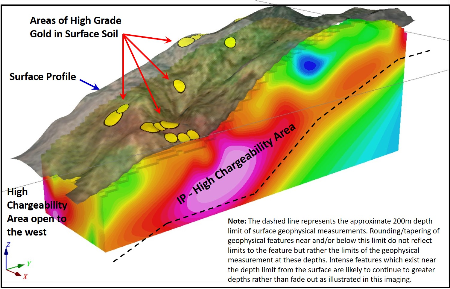
Figure 1 to this press release – “ Illustrative 3D IP-Chargeability Features -Section 61500E-Westward, Carneritos Area, Tenoriba Project” islocated on the eastern-most, north-south oriented geophysical line,looking west and illustrating a strong chargeability feature from this400 m interval, westward. Please refer to the Company website, www.mammothresources.ca “Projects” section,“Maps, Images & Photographs” for an animated 3D pass through2D sections, westward illustrating the progression of this featureover this 400 m interval. It is Mammoth’s intention to build ontothis 3D model additional data as it is interpreted from the field andillustrate the various anomalous features and corresponding potentialdrill targets, over the entire trend 6 km trend of the survey. Theseenhanced techniques have been enormously successful in identifyingattractive geophysical features not previously noted in this area andearly analysis of the additional surveyed lines from this 2021 programshow numerous similar enhanced results.
Thomas Atkins, President and CEO ofMammoth commented on the preliminary results of the ongoing Tenoribaexploration program, stating: "Completion of the infill geophysics is advancing well withapproximately two-thirds of the survey completed to date. We’re alittle behind where we’d hoped to be at this time, a result of theresimply being a lot of moving parts with many employees, consultants,local labour and logistical and covid related challenges associatedwith the survey and interpretation and modelling of data. I couldn’tbe more pleased with the efforts of the team and am happy to presentpreliminary 3D modelling of the first 400 metres of the approximate6-kilometre trend of surface and sporadically drill confirmedgold-silver mineralization at Tenoriba.
“A lot was learned followingMammoth’s maiden 2013 geophysical survey. This survey covered only40 percent of the mineralized trend and yet sporadic drilling, testingcombined geophysical and surface mineralized targets resulted inpotentially economical intervals of gold-silver and coppermineralization in an impressive 8 of 11 drill holes over 4 kilometresof the 6 kilometre trend.
“Advancing the current explorationprogram at Tenoriba, and in particular following the PhD review ofhistorical data from prior activities, it was evident successiveexploration activities had improved our understanding of the highsulphidation gold-silver mineralization model at Tenoriba.
“Mammoth’s collaboration withIntelligent Exploration and Drs. Ressel and Christensen of MDA/RESPEChas resulted in a thorough evaluation of all aspects of the historicaldata at Tenoriba and led to refinements in geophysical measurementtechniques to enable a more precise measurement of geophysicalfeatures in this infill survey. This work has significantly refinedthe geophysical modelling and helped define expanded trends to thepreviously drill-intersected mineralization, with a couple ofadditional kilometres yet to be surveyed. The 3D modelling currentlybeing illustrated in this press release is only the start of whatMammoth looks forward to illustrating over the coming weeks asadditional survey data is modelled and we move towards identifying anddrill testing these targets.”
Geological Mapping andSampling
Following the recommendations of Drs. Ressel and Christensen(MDA/RESPEC), field programs over the past 6 weeks have been focusedto enhance Mammoth’s understanding of the geological model atTenoriba. They include:
-
1. Remapping stratigraphy along the north facing, steep exposures in the central and easternportions of the 6 km trend of mineralization, with a review of drill core to test the possibility that earliermapping may have resulted in some stratigraphic inversion. As well asadditional trend-wide mapping of the volcanic breccia (a common hostof precious metal mineralization at Tenoriba and other highsulphidation systems) with the objective of establishing geologicalcharacteristics which may help determine volcanic flow vectors inorder to assist in defining the more hydrothermally intense areas ofthe Tenoriba system;
-
2. Contouring of previouslycollected and measured Absorption Spectrometer data (assists in theidentification of higher temperature areas of the hydrothermal systemamong clay minerals within the mineralized trend) from both down-holeand surface samples to vector into more hydrothermally intense zonesalong trend.
-
3. Expanded soil geochemical program extendingthe historical 2007-2008 soil grid by as much as 900 m west of the ElMoreno area, at 50 m sample spacings and along five-200 m spacednorth-south lines to investigate recently panned coarse gold in theregolith in this area. Samples have been sent to ALS Chemex labsfacility in Chihuahua to be assessed for gold via fire assay(lAu-AA23) and multi element analysis.
Based on the results from all of the above, Mammoth intends to combinethe refined geological map indicating volcanic flow vectors withhydrothermal intensity contouring and all geophysical data, to assistin establishing the best drill targets for the upcoming drill program.
Infill Geophysical Survey
A total of approximately 70 km of groundIP/Mag geophysics is to be performed over areas to the east, west andcovering gaps in between what had previously been surveyed overportions of the 6 km trend of surface mineralization at Tenoriba. Inaddition to the new survey lines, Mammoth also repeated three linesover the Carneritos area in the eastern portion of the trend, havingadjusted the methodology of the survey measurements in an attempt toenhance the observed features in this highly prospective area wheredrill hole TEN 17-06 intersected 126.8 metres grading 0.52 gram/tonnegold equivalent (including 7.2 gram/tonne silver converted to goldequivalent at 65:1 silver:gold ratio) and including a higher gradeinterval of 58.2 metres grading 0.81 gram/tonne gold equivalentsection (including 3.9 grams/tonne silver converted to gold at asimilar silver:gold ratio).
Collaboration with Mammoth and IE on the2021 infill IP/Mag survey, resulted in adjustments to the surveyparameters to more accurately match the particular characteristics ofthe mineralized targets at Tenoriba. IE began their surveyenhancements by measuring a suite of physical properties from surfaceand drill core samples from Tenoriba, which were collected by Mammothto establish the resistivity, chargeability, magnetic susceptibilityand other significant geophysical characteristics of these rocks tohelp with their identification in the geophysical data. Gold atTenoriba has been shown through surface and drill core samples, to becarried by quartz veins and in silicified volcanic rocks that areoften highly resistive. However, resistivity can be reduced in ablanket of weathered rocks covering the surface. As well, near-surfacechargeability can be depressed because fine-grained sulphidemineralization is oxidized by weathering, which could reduce itscontribution to the IP signal.
Historical IP surveys (measuringresistivity and chargeability) looked for persistent, anomalous“after voltages” (declining voltage) that might be present for upto two seconds after each polarizing pulse from the geophysical surveytransmitter. IE determined that the fine-grained sulphidemineralization at Tenoriba is shown more clearly by IP polarizationpulses that decay (this same declining voltage) much faster. IEre-processed the historical data to emphasize the early part of thispolarizing pulse which has led to stronger signals from thefine-grained mineralization and a better correlation with the knowngeology and drill results. For the current survey, similar rapid decayis being measured to enhance these Tenoriba specific features. Thesemeasurements have also been improved by the use of a stronger,early-time signal. 2D models of this data have been calculated in boththe historical and recent data and these models have been correlatedand validated using the field data to ensure that they show theanomalies with the greatest accuracy possible.
Three dimensional modelling of the IPresults for the Carneritos grid shows that gold targets can beidentified by a combination of characteristics: elevated chargeability(refer to Figure 1 - Illustrative 3D IP-ChargeabilityFeatures - Section 61500E-Westward, Carneritos Area, TenoribaProject ), higherresistivity and low magnetic susceptibility. Limited historicaldrilling has shown that gold values tend to be higher where both theIP chargeability and resistivity are higher or along structuralcontrols (faults). Such a target occurs in the southernportion of the 3D modelling of the Carneritos grid where surface soilgeochemistry data also indicates anomalous gold values. This offers anenticing target for follow-up with diamond drilling .
QualifiedPersons:
The IP/Mag survey is being conducted byGéophysique TMC (TMC) of Val d’Or Quebec, contracted by Mammothfrom TMC’s Mexico office. Chris Hale and John Gilliatt are theprincipal geophysicists at Intelligent Exploration. Dr. Chris Haleholds a BSc in Earth and Planetary Sciences from Erindale College,University of Toronto, a MA from the University of California and aPhD from the University of Toronto and has 45 years of mineralexploration experience. John Gilliatt holds a BSc in Geophysics fromthe University of Alberta and is registered as a PGeoph (Alberta) andhas over 30 years of mineral exploration experience. Both partnershold PGeo registration in Ontario and are members of the CanadianExploration Geophysical Society (KEGS). IE provides consultingservices under a Certificate of Authorization from the APGO(Association of Professional Geoscientists of Ontario). IE promotesgeophysical exploration in which techniques are individually tailoredto each type of target and provides assistance with survey selectionand implementation based on measured physical properties of targetmineralization.
About Mammoth Resources:
Mammoth Resources (TSX-V: MTH) is a precious metalmineral exploration Company focused on acquiring and defining preciousmetal resources in Mexico and other attractive mining friendlyjurisdictions in the Americas. The Company holds a 100% interest(subject to a 2% net smelter royalty purchasable anytime within twoyears from commencement of commercial production for US$1.5 million)in the 5,333 hectare Tenoriba gold property located in the SierraMadre Precious Metal Belt in southwestern Chihuahua State, Mexico.Mammoth is seeking other opportunities to option exploration projects in the Americas on properties it deemsto host above average potential for economic concentrations ofprecious metals mineralization.
To find out more about Mammoth Resources and to sign up to receivefuture press releases, please visit the company's website at: www.mammothresources.ca ., or contact Thomas Atkins, President andCEO at: 416 509-4326.
Neither the TSX Venture Exchange nor its RegulationServices Provider (as that term is defined in the policies of the TSXVenture Exchange) accepts responsibility for the adequacy or accuracyof this release.
Forward Looking Information: This news release maycontain or refer to forward-looking information. All information otherthan statements of historical fact that address activities, events ordevelopments that the Company believes, expects or anticipates will ormay occur in the future are forward-looking statements; examplesinclude the listing of its shares on a stock exchange and establishingmineral resources. These forward-looking statements are subject to avariety of risks and uncertainties beyond the Company's ability tocontrol or predict that may cause actual events or results to differmaterially from those discussed in such forward-looking statements.Any forward-looking statement speaks only as of the date on which itis made and, except as may be required by applicable securities laws,the Company disclaims any intent or obligation to update anyforward-looking statement, whether as a result of new information,future events or results or otherwise. Although the Company believesthat the assumptions inherent in the forward-looking statements arereasonable, forward-looking statements are not guarantees of futureperformance and, accordingly, undue reliance should not be placed onthese forward-looking statements due to the inherent uncertaintytherein.
Figure 1 -Illustrative 3D IP-Chargeability Features - Section 61500E-Westward,Carneritos Area, Tenoriba Project
Copyright (c) 2021 TheNewswire - All rights reserved.