MTH:CC - Mammoth Reports 39.0 Metres Grading 1.2 g/t Gold Equivalent from Diamond Drilling at its Tenoriba Gold-Silver Property Mexico
(TheNewswire)
Toronto, Canada – TheNewswire - December 15 ,2022 - Mammoth Resources Corp. (TSXV:MTH), (the “Company”, or “Mammoth”) is pleased to provide results from the final six drillholes from its 27-hole diamond drilling program at its 100% ownedTenoriba gold-silver property located in the Sierra Madre preciousmetal belt, Mexico .
The drill program was designed to test up to fivetarget zones which measure from hundreds of metres (m) to over onekilometre (km) in strike length along a 4 km, east-west trend ofgold-silver mineralization identified in 3-dimensional (3D) modellingincorporating data from over 3,000 soil, chip and channel samples, 26prior diamond drill holes, geological and structural mapping, and thepotential continuity at depth of surface mineralization as indicatedby an Induced Polarization/Magnetometer (IP/Mag) geophysical survey.
Results from an additional six diamond drill holes for a total of620.7 m brings the total metres drilled in the recent phase to3,244.25 m in 27 holes. Refer to Figure 1 - Location Map, Tenoriba Property Drilling, 2021-22 (drill holes TEN 21-01 to21-27) for the locations of all the 2021-22 program drill holes plusall historical drill holes on the Tenoriba property.
Thomas Atkins, President and CEO ofMammoth commented on these final drill results from its 2021-22 drillprogram, stating: "Similar to many of the prior holes reported from this program,we continue to intersect individual and cumulative intervals ofpotentially economical gold-silver mineralization extending over tensof metres. The Mammoth team is particularly encouraged as thesetens-of-metre, potentially economical intervals occur in all threeproject areas, each measuring greater than one kilometre in size,distributed over greater than a four-kilometre strike length and wheresurface mineralization remains open beyond this four-kilometre strike.
“Among the holes reported in thisrelease are those in which we stepped-out up to half a kilometre fromprior drilling to test new targets or potential lengthy extensions topreviously intersected mineralization. Reaching-out to these moredistant areas, we’re pleasantly surprised to encounter bothanomalous gold-silver mineralization over tens of metres, plus thereported, potentially economical mineralized intervals . These interval lengths and gold grades,considering that many occur at depths of under 100 metres and arepredominantly in oxidized rock over tens of metres in this largetarget area, continue to support a bulk, open pit mining and heapleach gold extraction scenario, in-line with what we’d hoped forfrom this drilling and analogous to other economical, HighSulphidation mines in the Sierra Madre.
“Several activities are beingadvanced to further enhance Mammoth’s understanding of economicconsiderations within these three principal mineralized areas, whilewe plan for t he next phase oftheir development . We lookforward to reporting on these activities in the comingweeks.”
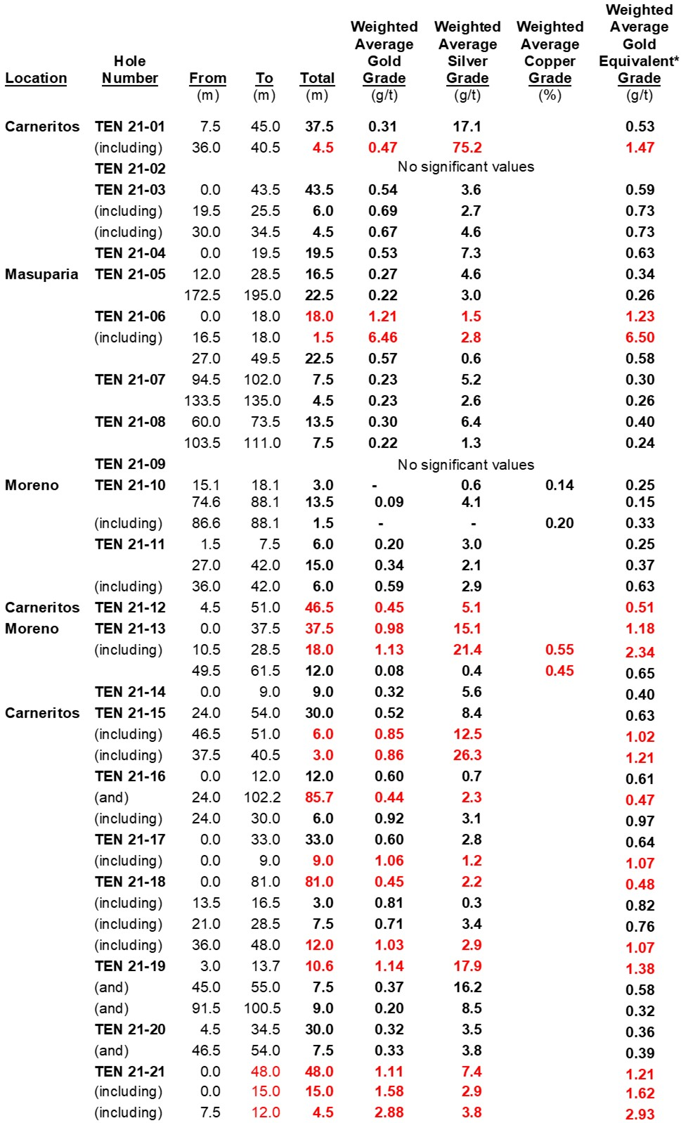
A summary of potentially economical intervals from the six drill holesfrom this press release are illustrated in the table below, includinghole TEN 21-24 in the Masuparia area, which intersected 39.0 m grading1.12 grams per/tonne (“g/t”) gold equivalent (“gold Eq”)followed by 42.0 m grading 0.48 g/t gold Eq.
| Hole |
| Weighted Average Gold |
| Weighted Average Silver |
| Weighted Average Copper |
| Weighted Average Gold Equivalent |
| Location |
| Number |
| From |
| To |
| Total |
| Grade |
| Grade |
| Grade |
| Grade |
| (m) |
| (m) |
| (m) |
| (g/t) |
| (g/t) |
| (%) |
| (g/t) |
| Carneritos |
| TEN 21-22 |
| 12.0 |
| 15.0 |
| 3.0 |
| 0.98 |
| 10.0 |
| 1.12 |
| 49.5 |
| 60.0 |
| 10.5 |
| 0.57 |
| 8.5 |
| 0.68 |
| TEN 21-23 |
| 0.0 |
| 6.0 |
| 6.0 |
| 0.52 |
| 5.5 |
| 0.60 |
| 54.0 |
| 55.5 |
| 1.5 |
| 0.14 |
| 74.8 |
| 1.13 |
| 70.5 |
| 76.2 |
| 5.7 |
| 0.20 |
| 0.8 |
| 0.21 |
| Masuparia |
| TEN 21-24 |
| 9.0 |
| 10.5 |
| 1.5 |
| 0.55 |
| 1.1 |
| 0.85 |
| 54.0 |
| 91.5 |
| 39.0 |
| 1.14 |
| 5.4 |
| 1.22 |
| (including) |
| 55.0 |
| 57.0 |
| 3.0 |
| 5.28 |
| 13.1 |
| 5.45 |
| (including) |
| 82.5 |
| 91.5 |
| 9.0 |
| 1.45 |
| 11.2 |
| 1.60 |
| (and) |
| 130.5 |
| 172.5 |
| 42.0 |
| 0.46 |
| 2.2 |
| 0.48 |
| (including) |
| 160.5 |
| 172.5 |
| 12.0 |
| 1.21 |
| 4.7 |
| 1.28 |
| Moreno |
| TEN 21-25 |
| No significant results |
| TEN 21-26 |
| 10.5 |
| 15.0 |
| 4.5 |
| 0.25 |
| 2.2 |
| 0.28 |
| 22.5 |
| 30.0 |
| 7.5 |
| 0.29 |
| 3.6 |
| 0.34 |
| TEN 21-27 |
| 1.5 |
| 10.5 |
| 9.0 |
| 0.41 |
| 3.6 |
| 0.46 |
Notes: * Gold Equivalent where silver grade isconverted to gold grade at 75 g/t silver = 1 g/t gold = 13.0 lbscopper.
Mammoth attempts to drill as near perpendicular asbelieved to be the orientation of mineralized control features,however drill set-up location options can challenge this objective.Intervals shown are core lengths versus perpendicular, true widths ofthese mineralized features.
Richard Simpson, Mammoth’s VicePresident Exploration further commented on these results,stating: “With the holesreported in this release, comprising the last few holes of theprogram, the Mammoth team put in the added effort to create the accessenabling us to test surface and geophysical features up to half akilometre from prior drilling and in the case of hole TEN 21-23,almost one kilometre from what appears the center of the largeCarneritos area. Hole TEN 21-23 potentially extends the size of theCarneritos area to almost a two-kilometre northeast strikelength.
“Mammoth geologists areparticularly excited by the mineral potential at Carneritos given itssize and the consistency we’ve had in producing tens of metreintervals of potentially economical mineralization in drill holesspaced hundreds of metres one from the other, as we attempt toidentify the boundaries of this large area.”
The drill results reported in this release complimentdrill intervals from the following 21 previously released drill holesfrom this program.
Drill Hole Description:
While conducting thisphase of exploration, Mammoth initially drilled 2 to 4 holes in eachof the three main target areas at significant, commonly at greaterthan 200 m from any prior drilling, then moved to another target areato drill a similar number of holes (please refer to press releasedated July 22, 2021 for target zones). Once these initial holes werelogged and on occasion, results received, drilling returned to eacharea to expand on the successes of the initial series of drill holes.Additional drilling, beyond the first pass of holes in each area, werein some instances as much as 700 m from any prior drilling to testvarious targets in each area. Where mineralized intervals wereintersected in the initial sequence of drilling, or where holes failedto encounter mineralization as suggested by the data, the location offollow up holes were based on the combination of results from theinitial sequence of drilling, combined with surface geology, soil,chip and channel sample results, geophysics data and ease/complexityof drill access. These field assessments were used to assist indefining additional drill collar locations for follow up holes in theprogram in order to understand and test the controls and continuity togold-silver mineralization over the large areas of surface gold-silverand occasionally copper mineralization.
Drill holes TEN 21-22 through TEN 21-27 were collaredto test some final targets to extend the boundaries of previouslydrill intersected mineralization in all three areas; Moreno, Masupariand Carneritos, and to test some new targets along the trend ofsurface gold-silver and occasional copper mineralization within theHigh Sulphidation (HS) mineralization model present at Tenoriba.
Drill Hole TEN 21-22 was collared in the epithermal HS gold-silver mineralized system in theCarneritos area. The hole was drilled to a depth of 71.70 m of a planned 100.0 m at 65 degreesdecline/dip, azimuth 130 degrees. The hole was collared approximately235 m south-southwest of hole TEN 17-06 and approximately 200 mwest-southwest of hole TEN 17-07 .
Hole TEN 21-22 was drilled to test the continuityof mineralization over the HS mineralizingsystem present at Carneritos and was targeting anear north - south ridge of altered and mineralized dacite porphyryand associated breccias under which a low resistivity and highchargeability geophysical feature was identified in the 3D geophysicsmodelling and upon which numerous rock chip samples returned >0.3g/t gold, including a 0.4 m chip sample grading 1.05 g/t gold and 42.9g/t silver. The prior drill holes in the vicinity of TEN 21-22,including hole TEN 17-06 intersected 126.85 m grading 0.58 g/t goldEq, including 58.2 m grading 0.80 g/t Eq, while hole TEN 17-07intersected 42.0 m grading 0.28 g/t gold Eq plus 12.5 m grading 0.36g/t gold Eq.
Drill hole TEN 21-22 intersectedthe dacite porphyry unit f rom surface to the bottom of the holeat 71.70 m with drill core generally grinded and/or highly fractured.The first 34.80 m are highly weathered and oxidized followed by amixed oxide-sulfide zone down to 41.20 m. From 48.0 to 60.0 m, theunit is brecciated with occasional weakly silicified zones with minordickite veinlets and very minor black sulfide veinlets, plus intervalswith up to 5% fine disseminated pyrite. It is the presence of thesesulfide minerals which are believed to be the likely source of thechargeability geophysical feature. It is suspected that the highlyweathered, oxidized and grinded core within the first 38.80 m resultsfrom a late, post mineralization fault. The dacite porphyry isbelieved to be major host of the epithermal HS mineralization presentin the Carneritos area.
Drilling on 50 to 100 m step-outs to the south, southwest andsoutheast of hole TEN 21-22 are recommended to test the continuity,extent and define the boundaries to gold-silver mineralization, inthese directions, within the Carneritos area.
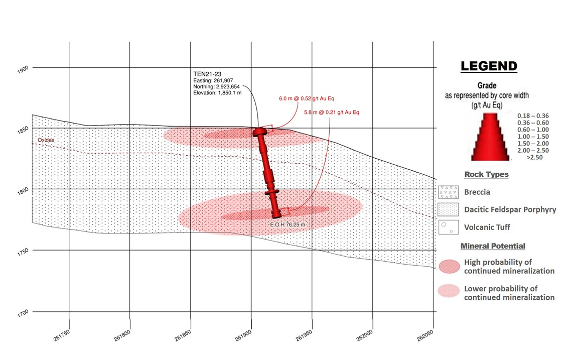
Drill Hole TEN 21-23 was collared in the epithermal HS gold-silver mineralized system in theCarneritos area. The hole was drilled to a depthof 76.25 m of a planned 100.0 m at 75 degrees decline/dip, azimuth 130degrees. The hole was collared approximately 450 m northeast of theeasterly-most hole drilled at Carneritos and 900 m from the center ofthe large Carneritos area.
Hole TEN 21-23 was drilled to test the continuity of mineralization over the HS mineralizing system present atCarneritos and was targeting the depth extensionto surface of altered dacite porphyry at the eastern boundary of theIP geophysical survey. The hole was collared 450 m east-northeast ofhole TEN 21-01 which returned 37.5 m grading 0.53 g/t gold equivalentEq, including 4.5 m grading 1.47 g/t gold Eq.
Drill hole TEN 21-23 wassuccessful in intercepting the targeted daciteporphyry unit from surface to the bottom of the hole at 76.25 m.R efer to Figure 2 -Drill Section, Drill Hole TEN 21-23 (looking east). Drill core is highly fractured throughout the entire 76.25 m lengthwith numerous intervals of grinded core containing minor faultgouging. The first 28.70 m are highly weathered, oxidized andunderwent argillic alteration. From 28.7 m to the end of the hole, thecore is fresh to moderately argillized containing up to 5%disseminated pyrite. The hole was abandoned at 76.25 m of the intended100.0 m depth as the drill rods were tightening in broken ground and as a resultthere was a risk the rods would become stuck andunrecoverable . Alteration was less than in otherparts of the Carneritos area, however host rocks and alteration remainconsistent with what would be expected on the periphery of a HSmineralizing system this hole having encountered anomalousgold-silver mineralization over tens of metres, including thereported, potentially economically mineralized intervals.
Detailed mapping and sampling is recommended in thearea east and west of this hole with the objective of evaluating theextent and degree of alteration within the dacite porphyry outcroppingin this area and further opportunities for economical gold-silvermineralization.
Drill Hole TEN 21-24
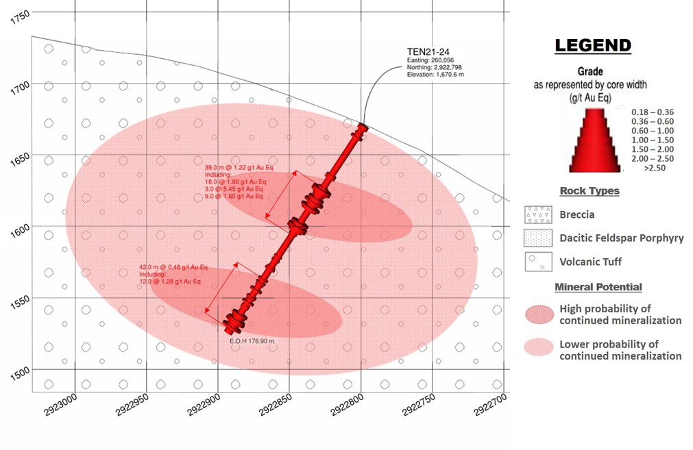
Drill Hole TEN 21-24 was collaredin the Masuparia Target area . The hole wasdrilled to a depth of 176.9 m of a planned 175.0 m at 55 degreesdecline/dip, azimuth 15 degrees . The hole iscollared 80 m west of historic hole TDH-12 and 100 m east of hole TEN17-10, drilled earlier in this program.
Hole TEN 21-24 was testing thecontinuity of mineralization along an approximate 1.2 km longnorthwest to west-northwest gold mineralization control-structureidentified by prior drilling and in the 3D geophysical modelling ofmagnetic (Mag) data. Historical hole TDH-12 returned 6.0 m grading0.59 g/t gold Eq and 12.0 m grading 0.38 g/t gold Eq while hole TEN17-10 returned 22.5 m grading 0.40 g/t gold Eq and 24.0 m grading 0.36g/t gold Eq.
Drill hole TEN21-24 intercepted from surface tobottom of the hole at 176.90 m, crystal lithic tuff generally weaklychloritized with overall 1 to 2% fine disseminated pyrite. R efer to Figure 3 - Drill Section, Drill Hole TEN 21-24 (lookingeast). The first 15.0 m are weathered and oxidizedfollowed by an oxide-sulfide transition zone down to 32.5 m. The gold and silver mineralized intercepts coincidewith broken to late brecciated intervals with the presence of blacksulfide in the breccia matrix and within irregular fine sulfidestringers. Mineralization within the Masuparia control-structureappears to provide a northern boundary to the geophysical magnetichigh (possibly indicative of an intrusive unit) to the south with IPresistivity (silicified unit) and chargeability (mineralized unit)geophysical features. Anomalous soils are frequent in the area inaddition to various mineralized drill intercepts within this 1.2 kmlong control-structure. The hole was a successful in intercepting tensof metres of gold-silver mineralization, including: 39.0 m grading1.22 g/t gold Eq. The crystal lithic volcanic tuff host rocks, theiralteration and the style of mineralization are more consistent withthose generally more distal to the core of a HS mineralizing system.
Follow up work in this area would require tighter drillspacing to further define the control-structural trend, includingreverse circulation drilling with surface trenching combined withdetailed mapping and sampling .
Drill Hole TEN 21-25
Drill Hole TEN 21-25 was collaredin the Moreno target area . The hole was drilledto a depth of 131.15 m of a planned 175.0 m at 80 degrees decline/dip,azimuth 185 degrees . The hole is collaredapproximately 500 m northwest of hole TEN 17-02 and 400 m northwest ofhole TEN 17-11.
Hole TEN 21-25 was targeting alow resistivity and high chargeability feature identified in the 3Dmodelling of the geophysical survey present from surface to the depthlimits of the geophysical survey at 200 m in the far northwesternportion of the Moreno area near the western limit of the IPgeophysical survey. Historical hole TEN 17-02 returned 80.0 m grading0.18 g/t gold Eq., including 9.0 m grading 0.52g/t while hole TEN 17-11 returned 227.8 m grading 0.14 g/t goldEq .
Mineralization in both historical drill holes is mainlyhosted by a feldspar porphyritic intrusive unit variably altered(chlorite/magnetite, illite and occasional tourmaline) with 5 to 15%pyrite, both disseminated and along fine irregular stringers. Inaddition, soil samples, to the south, downhill of this hole, returnedanomalous result grading up to 0.1 g/t gold. Hole TEN 21-25intercepted volcanic, crystal lithic tuff from 0.0 to 62.8 m containing up to 8% disseminated pyrite. The first7.5 m are weathered and oxidized. From 34.0 to 62.8 m the volcaniclithic crystal tuff is recrystallized and sericitized and becomes morehomogeneous. The lithic crystal tuff is followed by porphyritic daciteto the end of the hole. The core is highly fractured throughout withnumerous metre to greater than ten-metre intervals of fault grindedcore. The chargeability anomaly can be explained by the abundance ofdisseminated pyrite. The hole had to be abandoned short of the targetdepth because the rods were tightening in thebroken ground and as a result there was a risk the rods would becomestuck and unrecoverable.
Given the inability to drill the entire target depth,t he buried resistivity anomaly was not reachedand as such cannot be explained. The hole intercepted various samplelength intervals (1.5 m) of highly anomalous gold-silvermineralization (0.10 up to 0.27 g/t gold Eq), but these tended to beerratic rather than that they continued for tens of metres. For thetime being no further drilling or surface work recommendations overthis far northwestern portion of the Moreno target area.
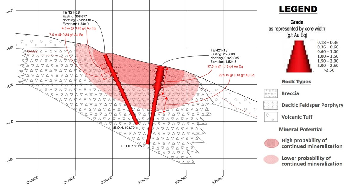
Drill Hole TEN 21-26 was collaredin the Moreno target area . The hole was drilledto a depth 103.7 m of a planned 100.0 m at 65 degrees decline/dip,azimuth 180 degrees . The hole is collared 65 mnorthwest of hole TEN 21-11, 75 m north-northwest of hole TEN 21-13and 72 m east-northeast of TEN 21-14.
Hole TEN 21-26 was targeting a high resistivity feature identified in the 3Dmodelling of the IP geophysical survey which coincides on surface withthe altered dacite porphyry and associated breccia present at theMoreno target area. Hole TEN 21-11 returned twopotentially economically mineralized intervals, including; 9.0 mgrading 0.25 g/t gold Eq. and 15.0 m grading 0.37 g/t gold Eq. HoleTEN 21-13 returned 37.5 m grading 1.18 g/t gold Eq. including 18.0 mgrading 2.34 g/t gold Eq. and hole TEN 21-14 returned 9.0 m grading0.40 g/t gold Eq.
Drill hole TEN21-26 intercepted alteredvolcanic breccia from 0.0 to 64.15 m .R efer to Figure 4 -Drill Section, Drill Hole TEN 21-26 (looking east). Thefirst 18.70 m are highly weathered and oxidized followed by mixedoxide-sulfide down to 64.15 m containing 7 to 12% fine disseminatedpyrite in the fresher core intervals accompanied by up to 2% irregulardickite stringers and moderate intervals of silicification. From 64.15m to the end of the hole at 103.70 m the hole intersected volcanic,lithic crystal tuff containing 10 to 15 % disseminated pyrite.Although the hole did not intercept tens of metres of gold-silver mineralization, it did intersect two intervals ofpotentially economical gold-silver mineralization within typical HSaltered dacite porphyry with additional highly anomalous gold-silver(0.10 to 0.26 g/t gold Eq) and occasional copper (0.34% copper)mineralization over numerous individual sample length intervals (1.5 m) over the initial 64.0 m. The altered daciteexplains the high resistivity feature observed in the geophysics.
Given the presence in this hole of the typical HSaltered dacite porphyry and associated breccia and intervals ofpotentially economical gold-silver mineralization observed in thishole and its neighbours ,it is recommended that following final interpretation additionaldrilling on 50 to 100 m drill spacings be undertaken to assess theeconomic potential of the area.
Drill Hole TEN 21-27
Drill Hole TEN 21-27 was collaredin the Moreno target area . The hole was drilledto a depth of 61.0 m of a planned 100.0 m at 60 degrees decline/dip,azimuth 110 degrees . The hole is collared 205 mand 210 m west-southwest of holes TEN 21-10 and TEN 17-03,respectively and 285 m west-northwest of hole TEN 21-14 .
Hole TEN 21-27 was targeting a break in a high resistivity feature and amoderate to high chargeability feature identified in the 3D modellingof the IP geophysical survey which coincides with the second largestartisanal mine present on the property where dickite was identified byX-ray Diffraction (XRD) analysis of rock samples and where numerousrock chip samples returned grades >1.0 g/t gold, the best resultsgrading 9.8 g/t gold over 1.0 m. Hole TEN 21-10 returned 3.0 m grading0.25 g/t gold Eq and 13.5 m grading 0.15 g/t gold Eq, while hole TEN17-03 returned 7.2 m grading 4.34 g/t gold Eq and hole TEN 21-14returned 9.0 m grading 0.40 g/t gold Eq.
Drill hole TEN 21-27 intercepted from surface to the bottomof the hole at 61.0 m, dacite porphyry with the first 25.20 beingweathered and oxidized followed by mixed oxide-sulfide down to 45.5 m.Where fresh rock, there exists 7 to 10% disseminated pyrite, howeverfrom 25.20 to 33.00 a porous interval is present where the sulfidesand feldspar phenocrysts have been washed-out. No significant silicaalteration was encountered, which could explain the break in theresistivity geophysical feature. The presence of the disseminatedpyrite explains the high chargeability feature. The hole was successful in intersecting the dacite porphyrywith the best assay results are associated with intervals containingdickite in otherwise reduced argillic and silica altered rocks whencompared to other areas on the property. The host rocks, mineralizingstyle and alteration is consistent with the Moreno HS target andbeyond the interval of potentially economical grade gold-silvermineralization, there occurred additional highly anomalous gold-silver(0.10 to 0.23 g/t gold Eq) mineralization over numerous individualsample intervals (1.5 m).
Given the presence in this hole of the typical HSaltered dacite porphyry and associated breccia and intervals ofpotentially economical gold-silver mineralization observed in thishole and its neighbours ,following final interpretation additional drilling is recommended on50 to 100 m drill spacings to advance the economic potential of thearea .
Qualified Person / Quality Controls:
Richard Simpson, P.Geo., Vice-President Exploration forMammoth Resources Corp. is Mammoth's Qualified Person, according toNational Instrument 43-101 for the Tenoriba property and isresponsible for and has reviewed any technical data mentioned in thisnews release.
Samples referenced in this press release were preparedand analyzed by ALS laboratories (ALS) in their facilities in Mexicoand Canada, respectively. Samples generally consisted of a minimum of2 kilograms of material. Drill core is mostly HQ diameter core withminor lengths of NQ diameter core. Core is sawn in half with a rocksaw with one half used for sample analysis purposes. Where samples are taken these are most often 1.5 metres inlength, only in poor recovery sections do they exceed this length,with rare exceptions exceeding a maximum of 4.5 metres in length.Samples are collected with sample ticket and deposited into plasticsample bags sealed with nylon zip lock ties, then loaded into grainsacs similarly sealed with a nylon zip lock tie prior to transport byMammoth personnel to ALS’s facility in Chihuahua, Mexico for samplepreparation. Gold and silver analyses are performed in ALS’sfacility in Canada via a 30-gram fire assay with an atomic absorptionfinish. Silver, copper, lead and zinc are analyzed as part of amulti-element ICP package using a 4-acid digestion. Any over limitsamples with greater than one percent copper, lead and zinc arere-analyzed using ore grade detection limits. Blank and duplicatesamples are inserted randomly at approximately every 15samples.
About Mammoth Resources:
Mammoth Resources (TSX-V: MTH) is a precious metalmineral exploration Company focused on acquiring and defining preciousmetal resources in Mexico and other attractive mining friendlyjurisdictions in the Americas. The Company holds a 100% interest(subject to a 2% net smelter royalty purchasable anytime within twoyears from commencement of commercial production for US$1.5 million)in the 5,333-hectare Tenoriba gold property located in the SierraMadre Precious Metal Belt in southwestern Chihuahua State, Mexico.Mammoth is seeking other opportunities to option exploration projectsin the Americas on properties it deems to host above average potentialfor economic concentrations of precious metalsmineralization.
To find out more about Mammoth Resources and to sign up to receivefuture press releases, please visit the company's website at: www.mammothresources.ca ., or contact Thomas Atkins, President andCEO at: 416 509-4326.
Neither the TSX Venture Exchange nor its RegulationServices Provider (as that term is defined in the policies of the TSXVenture Exchange) accepts responsibility for the adequacy or accuracyof this release.
Forward Looking Information: This news release maycontain or refer to forward-looking information. All information otherthan statements of historical fact that address activities, events ordevelopments that the Company believes, expects or anticipates will ormay occur in the future are forward-looking statements; examplesinclude the listing of its shares on a stock exchange and establishingmineral resources. These forward-looking statements are subject to avariety of risks and uncertainties beyond the Company's ability tocontrol or predict that may cause actual events or results to differmaterially from those discussed in such forward-looking statements.Any forward-looking statement speaks only as of the date on which itis made and, except as may be required by applicable securities laws,the Company disclaims any intent or obligation to update anyforward-looking statement, whether as a result of new information,future events or results or otherwise. Although the Company believesthat the assumptions inherent in the forward-looking statements arereasonable, forward-looking statements are not guarantees of futureperformance and, accordingly, undue reliance should not be placed onthese forward-looking statements due to the inherent uncertaintytherein.
Figure 1 - LocationMap, Tenoriba Property Drilling, 2021-22 (drill holes TEN 21-01 to TEN21-27)
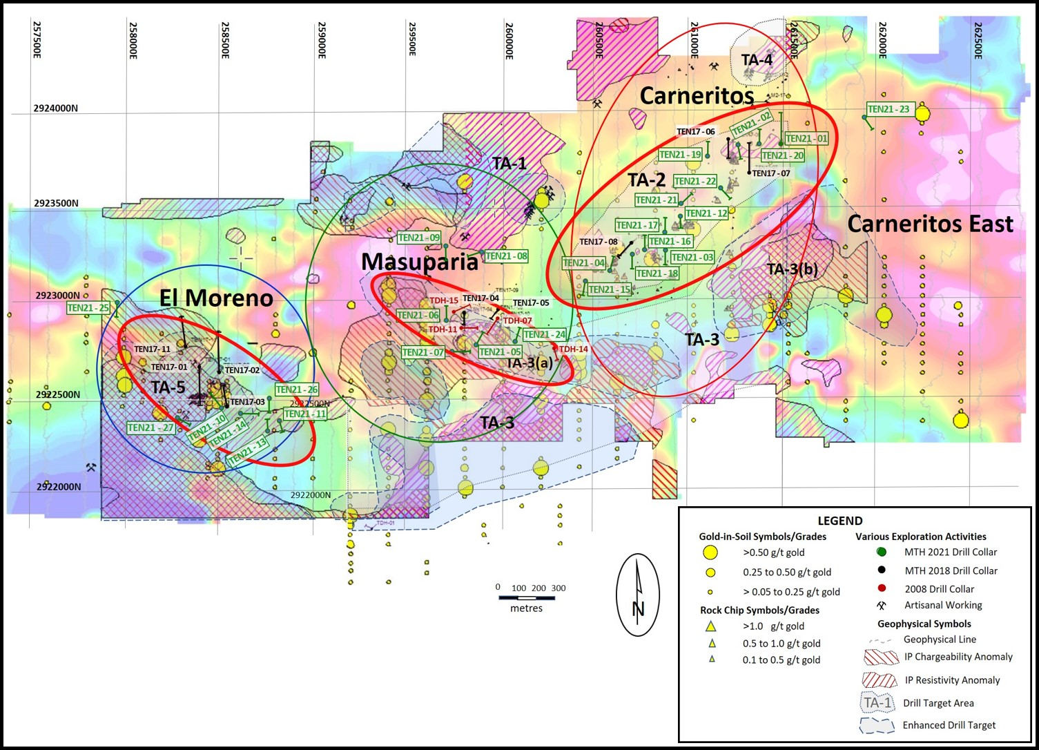
Figure 2 - DrillSection, Drill Hole TEN 21-23 (looking east)
Figure 3 - DrillSection, Drill Hole TEN 21-24 (looking east)
Figure 4 - DrillSection, Drill Hole TEN 21-26 (looking east)
Copyright (c) 2022 TheNewswire - All rights reserved.