MTH:CC - Mammoth Reports 81.0 Metres Grading 0.47 g/t and 48.0 Metres Grading 1.21 g/t Gold Equivalent from Diamond Drilling at its Tenoriba Gold-Silver Property Mexico
(TheNewswire)
Toronto, Canada – TheNewswire - August 04, 2022 - Mammoth Resources Corp.(TSXV:MTH), (OTC:MMMRF), (the “Company”, or “Mammoth”) is pleased to provide results from an additional fourdrill holes from its diamond drilling program at its 100% ownedTenoriba gold-silver property located in the Sierra Madre preciousmetal belt, Mexico .
The drill program was designed to test up to fivetarget zones which measure from hundreds of metres (m) to over onekilometre (km) in strike length along a 4 km, east-west trend ofgold-silver mineralization identified in 3-dimensional (3D) modellingincorporating data from over 3,000 soil, chip and channel samples, 26prior diamond drill holes, geological and structural mapping and thepotential continuity at depth of surface mineralization as indicatedby an Induced Polarization/Magnetometer (IP/Mag) geophysical survey.
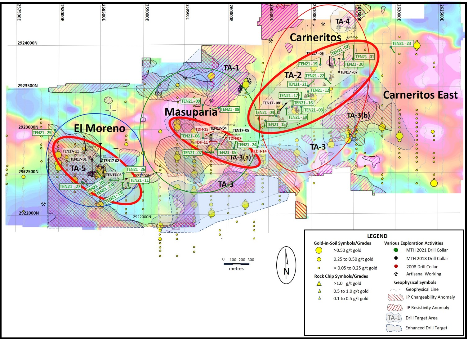
An additional four diamond drill holes have been completed for a totalof 388.95 m bringing the total reported to date to 2,623.55 m in 21holes. Refer to Figure 1 -Location Map, Tenoriba PropertyDrilling, 2021-22 (drill holes TEN 21-01 to 21-27). Asummary of potentially economical intervals from the four drill holesfrom this press release are as follows in the table below.
Thomas Atkins, President and CEO ofMammoth commented on the additional drill results, stating: "It’s encouraging to seeadditional successes in drilling within the large Carneritos areawhereupon we’ve intersected mineralization over a greater than onekilometre by 500 metre area. It’s especially encouraging to seecontinued, greater than 80 metre intervals of potentially economicalgold-silver mineralization and equally encouraging to see the 48 metreinterval grading over 1.2 grams per tonne gold equivalent. Theseinterval lengths and gold grades, taking into account they’reintersecting predominantly oxidized rock over tens of metres in thislarge target area, continue to support a bulk, open pit mining andheap leach gold extraction scenario, in-line with what we’d hopedfor from this drilling.
“Mammoth continues to block offareas hundreds of metres up to over a kilometre in size withsignificant step-outs from sparce historical drilling at Carneritos.Grades in this drilling are averaging those seen in multi-millionounce, High Sulphidation deposits currently being mined or underdevelopment by major mining companies in the same Sierra Madredistrict as Mammoth’s Tenoriba project .”
| Hole |
| Weighted Average Gold |
| Weighted Average Silver |
| Weighted Average Copper |
| Weighted Average Gold Equivalent |
| Location |
| Number |
| From |
| To |
| Total |
| Grade |
| Grade |
| Grade |
| Grade |
| (m) |
| (m) |
| (m) |
| (g/t) |
| (g/t) |
| (%) |
| (g/t) |
| Carneritos |
| TEN 21-18 |
| 0.0 |
| 81.0 |
| 81.0 |
| 0.45 |
| 2.2 |
| 0.4 8 |
| (including) |
| 13.5 |
| 16.5 |
| 3.0 |
| 0.81 |
| 0.3 |
| 0.82 |
| (including) |
| 21.0 |
| 28.5 |
| 7.5 |
| 0.71 |
| 3.4 |
| 0.76 |
| (including) |
| 36.0 |
| 48.0 |
| 12.0 |
| 1.03 |
| 2.9 |
| 1.07 |
| TEN 21-19 |
| 3.0 |
| 13.7 |
| 10.6 |
| 1.14 |
| 17.9 |
| 1.38 |
| (and) |
| 45.0 |
| 55.0 |
| 7.5 |
| 0.37 |
| 16.2 |
| 0.58 |
| (and) |
| 91.5 |
| 100.5 |
| 9.0 |
| 0.20 |
| 8.5 |
| 0.32 |
| TEN 21-20 |
| 4.5 |
| 34.5 |
| 30.0 |
| 0.32 |
| 3.5 |
| 0.36 |
| (and) |
| 46.5 |
| 54.0 |
| 7.5 |
| 0.33 |
| 3.8 |
| 0.39 |
| TEN 21-21 |
| 0.0 |
| 48.0 |
| 48.0 |
| 1.11 |
| 7.4 |
| 1.21 |
| (including) |
| 0.0 |
| 15.0 |
| 15.0 |
| 1.58 |
| 2.9 |
| 1.62 |
| (including) |
| 7.5 |
| 12.0 |
| 4.5 |
| 2.88 |
| 3.8 |
| 2.93 |
Notes: GoldEquivalent where silver grade isconverted to gold grade at 75 g/t silver = 1 g/t gold = 13.0 lbscopper.
Mammoth attempts to drill as nearperpendicular as believed to be the orientation of mineralized controlfeatures, however drill set-up location options can challenge thisobjective. Intervals shown are core lengths versus perpendicular, truewidths of these mineralized features.
Richard Simpson, Mammoth’s VicePresident Exploration further commented on these results,stating: “ Similar to what Tom is stating, I’mhighly encouraged by these results, both the lengthy intervals andintervals at higher grades. Based on surface geology and samplingresults we believed there was the potential for these higher grades.It’s terrific to be intersecting them over such interval lengths andwe believe this bodes well for future drilling and a robustgold-silver mineral resource at Carneritos.”
“Mammoth geologists areparticularly excited by the mineral potential at Carneritos given its1.4 kilometre by 500 metre size. The High Sulphidation target areas atCarneritos are similar, if not larger than those hosting million ounceplus reserves at other commercial mines in the same Sierra Madre beltas hosts Mammoth’s Tenoriba project.
“Abundant surface gold-silvermineralization occurs within a large 1,400 metre long by at least 500metre wide area typified by advanced, altered outcrops of rocks commonin these High Sulphidation deposits. These rocks and their associatedalteration assemblages, which coincide with geophysical features atdepth, continue to support a collapsed volcanic dome depositionalenvironment favourable for gold-silver mineralization atTenoriba."
The drill results from this release compliment drillintervals from the following 17 previously released drillholes.
| Hole |
| Weighted Average Gold |
| Weighted Average Silver |
| Weighted Average Copper |
| Weighted Average Gold Equivalent |
| Location |
| Number |
| From |
| To |
| Total |
| Grade |
| Grade |
| Grade |
| Grade |
| (m) |
| (m) |
| (m) |
| (g/t) |
| (g/t) |
| (%) |
| (g/t) |
| Carneritos |
| TEN 21-01 |
| 7.5 |
| 45.0 |
| 37.5 |
| 0.31 |
| 17.1 |
| 0.53 |
| (including) |
| 36.0 |
| 40.5 |
| 4.5 |
| 0.47 |
| 75.2 |
| 1.47 |
| TEN 21-02 |
| No significant values |
| TEN 21-03 |
| 0.0 |
| 43.5 |
| 43.5 |
| 0.54 |
| 3.6 |
| 0.59 |
| (including) |
| 19.5 |
| 25.5 |
| 6.0 |
| 0.69 |
| 2.7 |
| 0.73 |
| (including) |
| 30.0 |
| 34.5 |
| 4.5 |
| 0.67 |
| 4.6 |
| 0.73 |
| TEN 21-04 |
| 0.0 |
| 19.5 |
| 19.5 |
| 0.53 |
| 7.3 |
| 0.63 |
| Masuparia |
| TEN 21-05 |
| 12.0 |
| 28.5 |
| 16.5 |
| 0.27 |
| 4.6 |
| 0.34 |
| 172.5 |
| 195.0 |
| 22.5 |
| 0.22 |
| 3.0 |
| 0.26 |
| TEN 21-06 |
| 0.0 |
| 18.0 |
| 18.0 |
| 1.21 |
| 1.5 |
| 1.23 |
| (including) |
| 16.5 |
| 18.0 |
| 1.5 |
| 6.46 |
| 2.8 |
| 6.50 |
| 27.0 |
| 49.5 |
| 22.5 |
| 0.57 |
| 0.6 |
| 0.58 |
| TEN 21-07 |
| 94.5 |
| 102.0 |
| 7.5 |
| 0.23 |
| 5.2 |
| 0.30 |
| 133.5 |
| 135.0 |
| 4.5 |
| 0.23 |
| 2.6 |
| 0.26 |
| TEN 21-08 |
| 60.0 |
| 73.5 |
| 13.5 |
| 0.30 |
| 6.4 |
| 0.40 |
| 103.5 |
| 111.0 |
| 7.5 |
| 0.22 |
| 1.3 |
| 0.24 |
| Masuparia |
| TEN 21-09 |
| No significant values |
| Moreno |
| TEN 21-10 |
| 15.1 |
| 18.1 |
| 3.0 |
| - |
| 0.6 |
| 0.14 |
| 0.25 |
| 74.6 |
| 88.1 |
| 13.5 |
| 0.09 |
| 4.1 |
| 0.15 |
| (including) |
| 86.6 |
| 88.1 |
| 1.5 |
| - |
| - |
| 0.20 |
| 0.33 |
| TEN 21-11 |
| 1.5 |
| 7.5 |
| 6.0 |
| 0.20 |
| 3.0 |
| 0.25 |
| 27.0 |
| 42.0 |
| 15.0 |
| 0.34 |
| 2.1 |
| 0.37 |
| (including) |
| 36.0 |
| 42.0 |
| 6.0 |
| 0.59 |
| 2.9 |
| 0.63 |
| Carneritos |
| TEN 21-12 |
| 4.5 |
| 51.0 |
| 46.5 |
| 0.45 |
| 5.1 |
| 0.51 |
| Moreno |
| TEN 21-13 |
| 0.0 |
| 37.5 |
| 37.5 |
| 0.98 |
| 15.1 |
| 1.18 |
| (including) |
| 10.5 |
| 28.5 |
| 18.0 |
| 1.13 |
| 21.4 |
| 0.55 |
| 2.34 |
| 49.5 |
| 61.5 |
| 12.0 |
| 0.08 |
| 0.4 |
| 0.45 |
| 0.65 |
| M oreno |
| TEN 21-14 |
| 0.0 |
| 9.0 |
| 9.0 |
| 0.32 |
| 5. 6 |
| 0.4 0 |
| Carneritos |
| TEN 21-15 |
| 24.0 |
| 54.0 |
| 30.0 |
| 0.52 |
| 8.4 |
| 0.63 |
| (including) |
| 46.5 |
| 51.0 |
| 6.0 |
| 0.85 |
| 12.5 |
| 1.02 |
| (including) |
| 37.5 |
| 40.5 |
| 3.0 |
| 0.86 |
| 26.3 |
| 1.21 |
| TEN 21-16 |
| 0.0 |
| 12.0 |
| 12.0 |
| 0.60 |
| 0.7 |
| 0.61 |
| (and) |
| 24.0 |
| 102.2 |
| 85.7 |
| 0.44 |
| 2.3 |
| 0.47 |
| (including) |
| 24.0 |
| 30.0 |
| 6.0 |
| 0.92 |
| 3.1 |
| 0.97 |
| TEN 21-17 |
| 0.0 |
| 33.0 |
| 33.0 |
| 0.60 |
| 2.8 |
| 0.64 |
| (including) |
| 0.0 |
| 9.0 |
| 9.0 |
| 1.06 |
| 1.2 |
| 1.07 |
Drill Hole Description:
Mammoth initiallydrilled 2 to 4 holes at significant, up to 250 m drill spacings,within each target area then moved to another target area to drill asimilar number of holes (please refer to press release dated July 22,2021 for target zones). Company geologists would wait for the resultsfrom these initial 2 to 4 drill holes in a target area prior toreturning to the area to follow up drilling of these areas based onthe results from the initial holes. Where mineralized intervals wereintersected in the initial sequence of drilling, or where holes failedto encounter mineralization as suggested by the data, the location offollow up holes were based on the combination of results from theinitial sequence of drill holes combined with surface geology, soil,chip and channel sample results, geophysics data and ease/complexityof drill access. These field assessments were used to assist indefining additional drill collar locations for these follow up holesin order to understand and test the controls and continuity togold-silver mineralization.
Drill holes TEN 21-18 through TEN 21-21 were allcollared in the Carneritos target area where abundant surfacegold-silver mineralization occurs within a large 1,400 metre long byup to 500 metre wide area typified by advanced argillic alteredoutcrops of dacite porphyry and associated breccias with alterationassemblages of kaolinite, abundant dickite, silica and vuggy silica.These altered volcanic rocks coincide with a geophysical magneticlow. The magnetic low is believed to be the result of the destructionof magnetic minerals by intense mineralizing hydrothermal fluids, thesame fluids responsible for the alteration assemblages. These combinedfeatures are common within High Sulphidation (HS) altered volcanicrocks, typical of a collapsed volcanic dome.
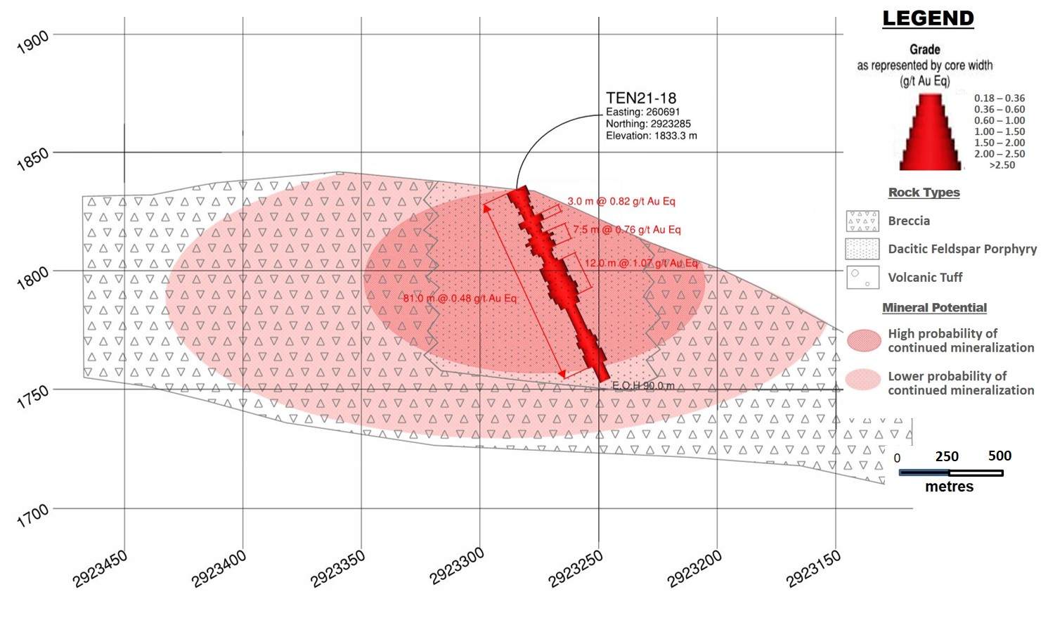
Drill Hole TEN 21-18
Drill Hole TEN 21-18 was collared in the epithermal HS gold-silver mineralized system in theCarneritos area. The hole was drilled to a depth of 88.5 m of aplanned 100.0 m at 65 degrees decline/dip, azimuth 180 degrees. Thehole was collared approximate 100 m east of TEN 21-04 and 200 m westof hole TEN 21-03.
Hole TEN 21-18 was drilled to in-fill the southwestern portion of themapped area of the HS mineralizing system at Carneritos over alteredand mineralized outcrops/sub-crops of dacitic volcanic breccia onsurface and a combined low IP geophysical resistivity andchargeability features with low magnetic features identified from the2021 infill geophysics survey. Holes TEN 21-03 and 04 returned 43.5 mgrading 0.59 g/t gold Eq and 19.5 m grading 0.63 g/t gold Eq,respectively.
Drill hole TEN21-18 intercepted from surface to bottom of the hole at88.5 metres highly weathered – fractured and generally argillizedand oxidized dacite porphyry. Silica alteration was present onlylocally and was generally weak. The hole did not reach its targeteddepth as it was abandoned due to poor ground conditions as drill rodstightened and were at risk of being lost. The hole returnedpotentially economical gold Eq values over the entire core intervaland given it had to be abandoned due to poor ground conditions, it isbelieved that additional potential exist for continued gold-silvermineralization at greater depths. Refer to Figure 2 - Drill Section, Drill HoleTEN 21-18 (looking east). Drilling in 50 to 100 m step-outs to thesouth and southeast are recommended to test the continuity and extentof gold-silver mineralization in these directions at Carneritos.
Drill Hole TEN 21-19
The hole was collared in the epithermal HS gold-silver mineralizedsystem in the Carneritos area. Drill hole TEN 21-19 was drilled to adepth of 122.0 m of a planned 150.0 m at 70 degrees decline/dip,azimuth 360 degrees. The hole was collared approximately 140.0 msouthwest of hole TEN17-06.
Hole TEN 21-19 was drilled to in-fill the northeastern portion of themapped area of the HS mineralizing system at Carneritos where a 100 mdeep vertical IP, resistivity feature exists underneath altered andmineralized dacite porphyry and associated breccia on surfaceassociated with advanced argillic alteration identified by Terraspeck(alteration clay analysis) analysis on surface samples and within 2017drill core wherein the presence of dickite, silica, pyrophyllite andvuggy silica were observed. HoleTEN17-06 returned 126.2 m grading 0.59 g/t gold Eq, including 58.2 mgrading 0.80 g/t gold Eq.
Drill hole TEN 21-19 intercepted in the first 13.7 m highly weatheredand oxidized, moderately to strongly silicified volcanic breccia withdickite, alteration clay infilling irregular fractures. Below 13.7 mthe rock was moderately, argillized lithic crystal volcanic tuff whichcontinued to a depth of 90.4 m of which the first approximate 15 m toapproximately 30 m, was also highly oxidized. The core contained 5%fine disseminated pyrite and local black sulfide infilling irregularfractures. From 90.4 to 103.3 m, the core consisted of weakly tomoderately silicified volcanic breccia with dickite infillingirregular fractures with up to 12% disseminated fine pyrite followedby a similar lithic crystal volcanic tuff (as described above), downto 108.1 m. From 108.1 m to 122.0 m the core consisted of weaklyargillized/sericitized dacite porphyry with up to 10% disseminatedpyrite. The hole successfully identified the IP, geophysicsresistivity feature by the presence of the silicified volcanic brecciafrom 90.4 to 103.3 m. The hole also identified numerous intervals ofvariably altered and/or mineralized dacite porphyry and associatedbreccia with late event faults ere observed to be displacingstratigraphy and mineralization. It is recommended that detailedsurface mapping of structural, stratigraphic and alteration featuresbe performed in this area prior to drill hole targeting to betterunderstand controls to mineralization in an effort to define thenorthcentral-northeastern limits to gold-silver mineralization at Carneritos.
Drill Hole TEN 21-20
The hole was collared in the epithermal HS gold-silver mineralizedsystem in the Carneritos area. Drill hole TEN 21-20 was drilled to adepth of 108.3 m of a planned 125.0 m at 80 degrees decline/dip,azimuth 360 degrees. The hole is collared approximately 100.0 m westof hole TEN 21-01.
Hole TEN 21-20 was drilled to in-fill the northeastern portion of themapped area of the HS mineralizing system at Carneritos where a 100 mdeep vertical IP, geophysical resistivity feature was observed and totest the continuity of gold-silver mineralization in this portion ofthe Carneritos area where Hole TEN 21-01, 100 m east of hole TEN 21-20returned 37.5 m grading 0.53 g/t gold Eq.
Drill hole TEN 21-20 intercepted from surface to bottom at 108.3 m thedacite porphyry unit of which the first 18.7 m corresponds toweathered oxide zone followed by a sulfide-oxide transition zone downto 21.5 m. In addition, down to 34.35 m minor oxide filled fracturesare present consisting of up to 7% disseminated pyrite and minorirregular black sulfide stringers. Results from this hole failed toexplain the buried IP geophysical feature. The hole was successful inidentifying almost 50 m of potentially economical gold-silvermineralization tens of metres of economical gold-silver mineralizationwithin what is interpreted as an altered dacitic porphyry dome atCarneritos. Further drilling isrecommended 50 to 100 m to the north and south of this hole to assistin defining the northeastern limits to gold-silver mineralization atCarneritos.
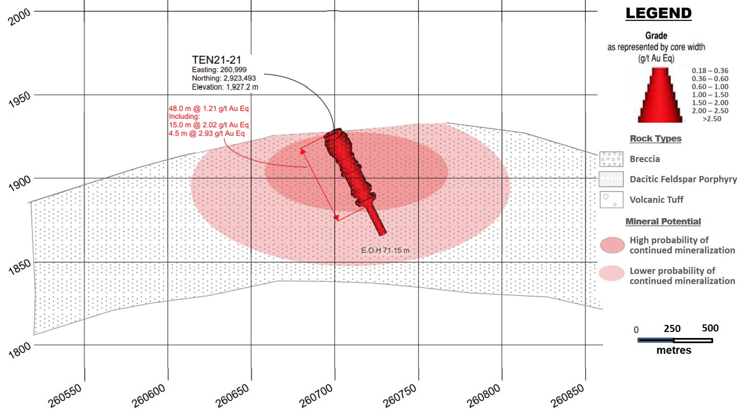
Drill Hole TEN 21-21
The hole was collared in the epithermalHS gold-silver mineralized system in the Carneritos area. Drill holeTEN 21-21 was drilled to a depth of 71.15 m of a planned 100.0 m at 60degrees decline/dip, azimuth 060 degrees. The hole is collaredapproximately 60.0 m north of hole TEN21-12.
Hole TEN 21-21 was drilled to infill the drill spacing within thecentral portion of the mapped area of the HS mineralizing system atCarneritos where altered dacite porphyry and associated breccias havebeen mapped on surface and sub vertical flow banding are present inoutcrops. The hole was designed to intercept close to perpendicularthe flow bands. Hole TEN 21-12, returned 46.5 m grading 0.51 g/t goldEq.
Drill hole TEN 21-21 intercepted from surface to the bottom of thehole at 71.15 m moderately to strongly silicified dacite porphyry withvarious breccia intervals and presence of dickite alteration clayinfilling irregular fractures and veinlets and replacing feldsparphenocrysts and generally low volumes (1%) disseminated pyrite. Theunit is oxidized down to a depth of 47.2 m. The hole was successful inintercepting almost 50 m of higher than 1.2 g/t gold Eq gold-silvermineralization, one of the highest grade-thickness holes drilled atCarneritos to date. Refer to Figure3 - Drill Section, Drill Hole TEN 21-21 (looking east). Furtherdrilling from 50 to 200 m to the north, west and northwest of thishole is recommended to assist in defining the northcentral limits togold-silver mineralization at Carneritos.
Qualified Person / QualityControls:
Richard Simpson, P.Geo., Vice-President Exploration forMammoth Resources Corp. is Mammoth's Qualified Person, according toNational Instrument 43-101 for the Tenoriba property and isresponsible for and has reviewed any technical data mentioned in thisnews release.
Samples referenced in this press release were preparedand analyzed by ALS laboratories (ALS) in their facilities in Mexicoand Canada, respectively. Samples generally consisted of a minimum of2 kilograms of material. Drill core is mostly HQ diameter core withminor lengths of NQ diameter core. Core is sawn in half with a rocksaw with one half used for sample analysis purposes. Where samples aretaken these are most often 1.5 metres in length, only in poor recoverysections do they exceed this length, with rare exceptions exceeding amaximum of 4.5 metres in length. Samples are collected with sampleticket and deposited into plastic sample bags sealed with nylon ziplock ties, then loaded into grain sacs similarly sealed with a nylonzip lock tie prior to transport by Mammoth personnel to ALS’sfacility in Chihuahua, Mexico for sample preparation. Gold and silveranalyses are performed in ALS’s facility in Canada via a 30-gramfire assay with an atomic absorption finish. Silver, copper, lead andzinc are analyzed as part of a multi-element ICP package using a4-acid digestion. Any over limit samples with greater than one percentcopper, lead and zinc are re-analyzed using ore grade detectionlimits. Blank and duplicate samples are inserted randomly atapproximately every 15 samples.
About Mammoth Resources:
Mammoth Resources (TSX-V: MTH) is a precious metalmineral exploration Company focused on acquiring and defining preciousmetal resources in Mexico and other attractive mining friendlyjurisdictions in the Americas. The Company holds a 100% interest(subject to a 2% net smelter royalty purchasable anytime within twoyears from commencement of commercial production for US$1.5 million)in the 5,333-hectare Tenoriba gold property located in the SierraMadre Precious Metal Belt in southwestern Chihuahua State, Mexico.Mammoth is seeking other opportunities to option exploration projectsin the Americas on properties it deems to host above average potentialfor economic concentrations of precious metalsmineralization.
To find out more about Mammoth Resources and to sign up to receivefuture press releases, please visit the company's website at: www.mammothresources.ca ., or contact Thomas Atkins, President andCEO at: 416 509-4326.
Neither the TSX Venture Exchange norits Regulation Services Provider (as that term is defined in thepolicies of the TSX Venture Exchange) accepts responsibility for theadequacy or accuracy of this release.
Forward Looking Information: This newsrelease may contain or refer to forward-looking information. Allinformation other than statements of historical fact that addressactivities, events or developments that the Company believes, expectsor anticipates will or may occur in the future are forward-lookingstatements; examples include the listing of its shares on a stockexchange and establishing mineral resources. These forward-lookingstatements are subject to a variety of risks and uncertainties beyondthe Company's ability to control or predict that may cause actualevents or results to differ materially from those discussed in suchforward-looking statements. Any forward-looking statement speaks onlyas of the date on which it is made and, except as may be required byapplicable securities laws, the Company disclaims any intent orobligation to update any forward-looking statement, whether as aresult of new information, future events or results or otherwise.Although the Company believes that the assumptions inherent in theforward-looking statements are reasonable, forward-looking statementsare not guarantees of future performance and, accordingly, unduereliance should not be placed on these forward-looking statements dueto the inherent uncertainty therein.
Figure 1 - LocationMap, Tenoriba Property Drilling, 2021-22 (drill holes TEN 21-01 to TEN21-27)
Figure 2 - DrillSection, Drill Hole TEN 21-18 (looking east)
Figure 3 - DrillSection, Drill Hole TEN 21-21 (looking east)
Copyright (c) 2022 TheNewswire - All rights reserved.