MMMRF - Mammoth Reports Further Results from its Diamond Drilling Program at its Tenoriba Gold-Silver Property Mexico
(TheNewswire)
Toronto, Canada – TheNewswire - March 3, 2022 - Mammoth Resources Corp.(TSXV:MTH), (OTC:MMMRF) , (the “Company”, or “Mammoth”) is pleased to provide results from an additional three drill holesfrom its diamond drilling program at its 100% owned Tenoribagold-silver property located in the prolific Sierra Madre preciousmetal belt, Mexico.
The drill program is designed to test up to five targetzones which measure from hundreds of metres (m) to over one kilometre(km) in strike length along a 4 km, east-west trend of gold-silvermineralization identified in 3-dimensional (3D) modellingincorporating data from over 3,000 soil, chip and channel samples, 26prior diamond drill holes, geological and structural mapping and thepotential continuity at depth of surface mineralization as indicatedby an Induced Polarization/Magnetometer (IP/Mag) geophysical survey(please refer to the descriptions of target zones in the press releasedated July 22, 2021).
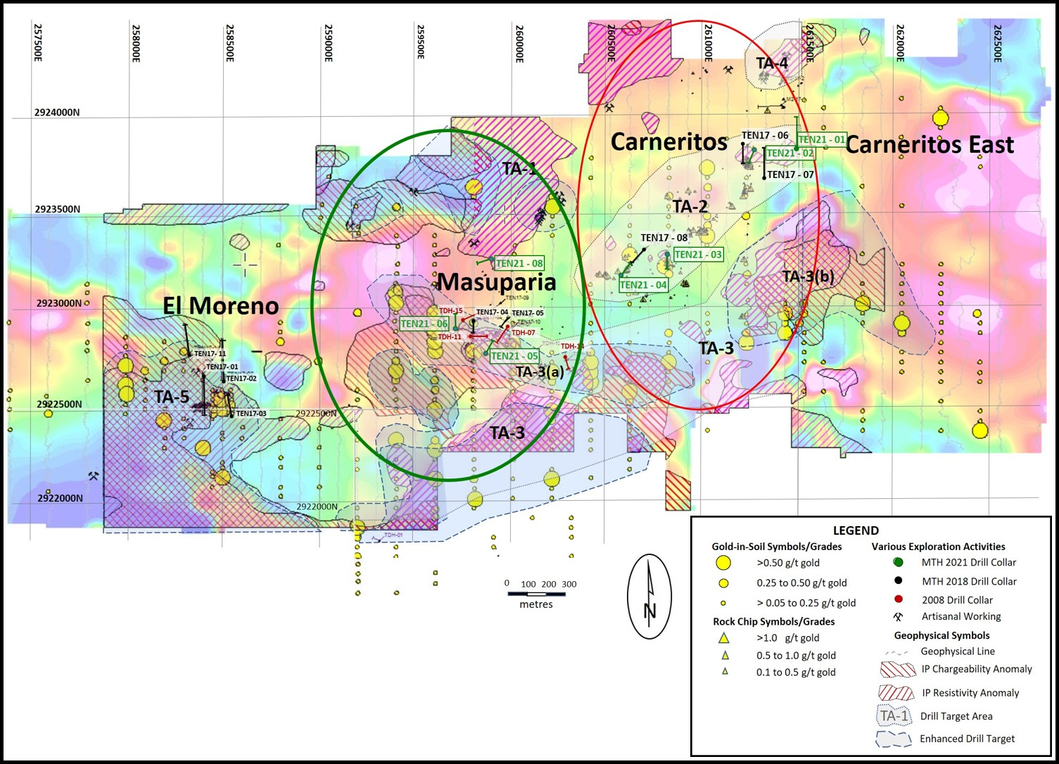
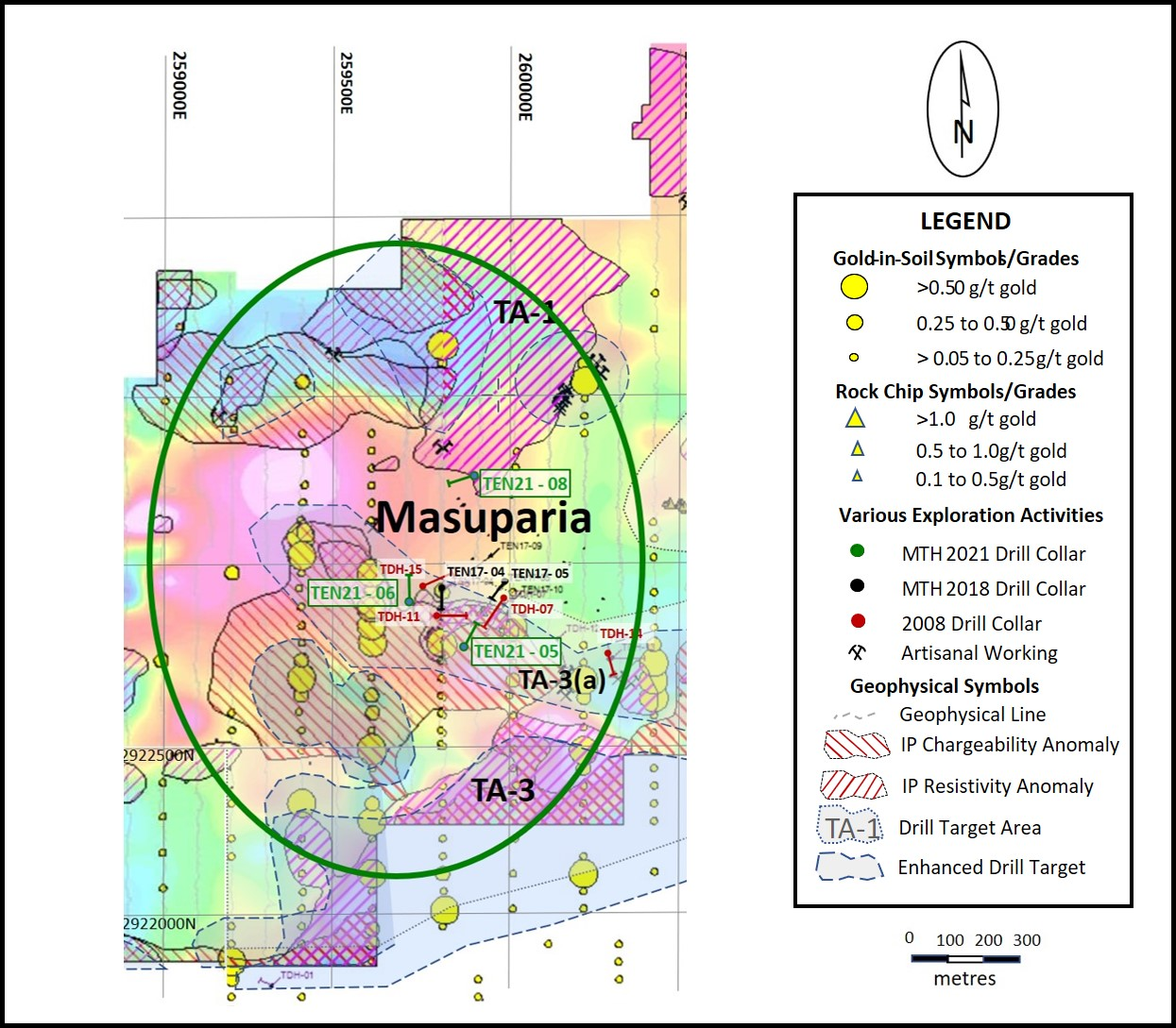
An additional three diamond drill holes have beencompleted for a total of 569.5 metres bringing the total metres (m)reported to date to 995.5 m in 7 holes. The first four holes testedthe TA-2 target in the Carneritos area of the project (refer to pressrelease dated November 18, 2021, Figure 1 and Figure 2 ) while thesethree holes tested the TA-3(a) target in thecentral Masuparia area of the project, approximately 700 m from theclosest Carneritos drilling (refer to Figure 1 - LocationMap, Location Map, TenoribaProperty Drilling, 2022 (drill holes TEN 21-05, 06 and08) and Figure 2 - Location Map, Masuparia Area,Tenoriba Property Drilling, 2022 (drill holes TEN 21-05, 06 and08 ). A summary of potentially economicalintervals from these additional three holes are as follows.
| Hole |
| Weighted Average Gold |
| Weighted Average Silver |
| Weighted Average Gold Equivalent* |
| Location |
| Number |
| From |
| To |
| Total |
| Grade |
| Grade |
| Grade |
| (m) |
| (m) |
| (m) |
| (g/t) |
| (g/t) |
| (g/t) |
| Masuparia |
| TEN 21-05 |
| 12.0 |
| 28.5 |
| 16.5 |
| 0.27 |
| 4.6 |
| 0.34 |
| 172.5 |
| 195.0 |
| 22.5 |
| 0.22 |
| 3.0 |
| 0.26 |
| TEN 21-06 |
| 0.0 |
| 18.0 |
| 18.0 |
| 1.21 |
| 1.5 |
| 1.23 |
| (including) |
| 16.5 |
| 18.0 |
| 1.5 |
| 6.46 |
| 2.8 |
| 6.50 |
| 27.0 |
| 49.5 |
| 22.5 |
| 0.57 |
| 0.6 |
| 0.58 |
| (including) |
| 27.0 |
| 39.0 |
| 12.0 |
| 0.83 |
| 0.5 |
| 0.84 |
| TEN 21-08 |
| 60.0 |
| 73.5 |
| 13.5 |
| 0.30 |
| 6.4 |
| 0.40 |
| 103.5 |
| 111.0 |
| 7.5 |
| 0.22 |
| 1.3 |
| 0.24 |
Notes: GoldEquivalent where silver grade is converted togold grade at 75 grams per tonne silver = 1 gram per tonnegold.
Mammoth attempts to drill as near perpendicular asbelieved to be the orientation of mineralized control features,however lengths shown are core lengths versus perpendicular truelength of mineralized intersections.
Thomas Atkins, President and CEO ofMammoth commented on the initial results from the Tenoriba diamonddrill program stating: "We continue to intersect potentially economical gold-silvergrades over lengthy, tens of metre intervals at generally shallowdepths in significant step-out distances from prior drilling. In thiscase, in addition to the interval lengths, we hit some impressivegrades in hole 21-06. Although lower grades in holes 05 and 08, theseintervals continue to be potentially economical and add to what wouldbe an average grade taking into account the combination ofhigher-grade intervals such as those intersected in 21-06.
“It’s important to keep in mindthat Tenoriba is a very large, at least 4 to 6 kilometre longmineralized system with gold-silver sampled in thousands of surfacesamples and as such an excellent candidate for large scale open pitmining. As evidenced in hole 21-06 and numerous other historic drillholes, we can often intersecttens of metres of higher-grade gold-silver mineralization at shallowdepths, accompanied by similar intervals of more modest, yet stillpotentially economical grades.
“What’s encouraging about thehigher-grade intervals at Tenoriba is that the mineralized trend beingas large as it is and taking into account that we’re testing targetareas that measure hundreds of metres to over a kilometre in lengthand drilling 60 to greater than 200 metres step-outs from sparse priordrilling, when one considers the that the drill core measures only 6.5centimetres in diameter, hitting these higher grade intervals withinthis giant mineralized system at Tenoriba, in these large step-outs,we’re literally encountering needles in a haystack of mineralizationat this stage of the drilling. However, as evidenced by thesehigher-grade intervals we’re able to intersect these ‘needles’in this ‘haystack’ which bodes well for the potential of theproject.”
Richard Simpson, Mammoth’s VicePresident Exploration further commented on these results,stating: “ Holes in the Masuparia target area weredesigned to test possible-interpreted structural and/or stratigraphiccontrols associated with gold-silver mineralized intervals encounteredin prior drilling. All three holes intercepted anomalous gold-silverover tens of metres. In all holes the mineralization appears to becontrolled by irregular sulphide enriched fractures-veinlets withminor quartz and/or alteration clay minerals typical to HighSulphidation mineral systems. Mineralization in the Masuparia area iscomplex given what appears the combination of structural andstratigraphic controls. Understanding these controls remains a workin-progress with our gaining further insights with every additionaldrill hole.”
Drill Hole Description:
As previously discussed,Mammoth intends to initially drill 2 to 4 holes within each targetzone then move to another target zone to drill a similar number ofholes (please refer to press release dated July 22, 2021 for targetzones). Company geologists intend to await the results from theinitial 2 to 4 drill holes in a target area prior to returning to thearea to follow up drilling of these areas. Where mineralized intervalsare intersected in the initial sequence of drilling, or where holesfail to encounter mineralization as suggested by the data, follow updrilling will be based on field assessments combined with surfacegeology, sampling and geophysics data to assist in defining follow updrill collar locations with the aim of assisting in more clearlyunderstanding and testing the controls and continuity to gold-silvermineralization.
Targets TEN 21-05 and 06 were drilled to test theinterpreted F3, west-northwest fault as identified in the 3Dgeophysical interpretation within the generally west-northwest – east-southeastTA-3(a) mineralized trend /target area. In bothholes the F3 fault was intercepted and coincides with highlyfractured/grinded core intervals from 113 to 139 and 117 to 124 m corelength in hole 21-05 and 21-06, respectively. These intervals were notmineralized. As a result, it can be said that the F3 fault appears tobe an un-mineralized, late, normal fault (south block down) and themineralization intervals encountered in these holes does not appear tobe fault controlled, but may be an extension of the generalwest-northwest - east-southeast TA-3(a) mineralized trend.
The second target; TEN21-08 was drilled to test thenorth extension of the west-northwest trending Metalito structurewhich was observed in a small artisanal mine where surface samplesassayed up to 1.3 grams/tonne (g/t) gold over 1.8 m and where dickiteclay (an alteration clay commonly observed in High Sulphidationprecious metal systems), was also observed. The Metalito structure wasintercepted from 58 to 76 m and it was within this structure that thereported gold-silver values were encountered.
Drill Hole TEN 21-05
The hole was drilled to a depth of 220.5 m of a planned 200 to 250 mdepth at 65 degrees decline/dip, azimuth 20 degrees and was collaredapproximately 170 m east-southeast of TDH-10 and 175 m southwest ofTDH-07. This drill hole was collared to test theinterpreted F3, west-northwest fault as identified in the 3Dgeophysical interpretation within what appears a possible west-northwest andeast-southeast mineralized trend as identifiedin target area TA-3(a).
Historic drill hole TDH-10 returned 26.7 m grading 0.66 g/t goldequivalent (Eq) followed by 41.0 m grading 0.92 g/t gold Eq, whileTDH-07 returned 47.0 m grading 2.17 g/t gold Eq followed by 11.5 mgrading 2.32 g/t gold Eq.
TEN 21 - 05 intercepted from surface to 194 m core length crystalvolcanic tuff with traces, to up 5% locally of pyrite in irregularveinlets with minor quartz throughout. From 113 to 139 m core lengthfrequent intervals of broken and grinded core were noted whichcoincides with the interpretation of the F3 fault. As the faultinterval was not mineralized it is interpreted to be a late, normalfault (south block down) and the mineralizationinterval encountered in this hole does not appear to be faultcontrolled but rather appears to be an extension of the generallywest-northwest and east-southeast mineralized trend. Hole TEN 21 - 06collared 200 m northwest of TEN 21-05 was drilled to further test thisstructure and the possible west-northwest and east-southeastmineralized trend as identified in target area TA-3(a).
Drill Hole TEN21-06
The hole was drilled to a depth of 196.5 m of a planned 200 to 250 mdepth at 55 degrees decline/dip, azimuth 0 degrees and was collaredapproximately 75 m southeast of TEN17-15, 65 m west-southwest of collar TDH-11. This drill hole wascollared to test the interpreted F3, west-northwestfault as identified in the 3D geophysical interpretation within whatappears a possible west-northwest and east-southeast mineralized trendas identified in target area TA-3(a).
Historic drill hole TEN17-15 returned 12 m grading 0.71 g/t gold Eqfollowed by 13.6 m grading 0.47 g/t gold Eq, and TDH-11 returned 26.7m grading 0.66 g/t gold Eq followed by 41 m grading 0.92 g/t gold Eq.
TEN 21-06 intercepted from the top to the bottom of the hole crystalvolcanic tuff, generally weakly sericitized and or chloritized withless than 1% disseminated fine pyrite. From 117 to 124 m core lengthfrequent intervals of broken and grinded core were noted whichcoincides with the interpretation of the F3 fault. As the faultinterval was not mineralized it is interpreted to be a late, normalfault (south block down) and the mineralizationintervals encountered in this hole does not appear to be faultcontrolled but rather is an extension of the generally west-northwestand east-southeast mineralized trend.
Drill Hole TEN21-08
The hole was drilled to a depth of 152.5 m of a planned 100 m depth at60 degrees decline/dip, azimuth 250 degrees and was collaredapproximately 700 m northwest of TEN17-09. This drill hole wasoriginally intended to be collared 400 m further northwest of itsdrilled location corresponding with both a large IP geophysics featureat this original location and what would be a lengthylateral extension to the Metalito targeted structure. The holewas unable to be located at its original location due to the steepnessof the ground at this location. This hole was instead collared alongstrike of the Metalito structure below a small mine working wheredickite clay alteration (an alteration clay commonlyobserved in High Sulphidation precious metal systems) waspresent and numerous surface gold assays existed, the best result 1.3g/t gold over 1.8 m.
Historic drill hole TEN17-09 intersecting the Metalito structurereturned 3 m grading 0.42 g/t gold Eq.
TEN 21-08 intercepted from surface to 58 m core length,non-mineralized lithic volcanic tuff, followed by the Metalitostructure from 58 to 76 m. The Metalito structure coincides withmineralized, brecciated volcanic tuff with abundant presence of pyriteveinlets and an approximate 1 m interval with white clay and sulfideveinlets at a 65° angle from the core axis. From 76 meters to the endof the hole there was a repeat of the same non-mineralized lithicvolcanic tuff. This drill hole demonstrates lengthylateral continuity of this Metalito mineralizedstructure, given its 700 m step-out from any prior drilling althoughwith modest, yet potentially economical grade mineralization over adecent 13.5 m interval at a relatively shallow, less than 50 mvertical depth. The original, large IP geophysics feature, alongstrike with the Metalito structure located in the steep terrain 400 mto the northwest, remains to be tested.
Qualified Person / QualityControls:
Richard Simpson, P.Geo., Vice-President Exploration forMammoth Resources Corp. is Mammoth's Qualified Person, according toNational Instrument 43-101 for the Tenoriba property and isresponsible for and has reviewed any technical data mentioned in thisnews release.
Samples referenced in this press release were preparedand analyzed by ALS laboratories (ALS) in their facilities in Mexicoand Canada, respectively. Samples generally consisted of a minimum of2 kilograms of material. Drill core is mostly HQ diameter core withminor lengths of NQ diameter core. Core is sawn in half with a rocksaw with one half used for sample analysis purposes. Where samples aretaken these are most often 1.5 metres in length, only in poor recoverysections do they exceed this length, with rare exceptions exceeding amaximum of 4.5 metres in length. Samples are collected with sampleticket and deposited into plastic sample bags sealed with nylon ziplock ties, then loaded into grain sacs similarly sealed with a nylonzip lock tie prior to transport by Mammoth personnel to ALS’sfacility in Chihuahua, Mexico for sample preparation. Gold and silveranalyses are performed in ALS’s facility in Canada via a 30-gramfire assay with an atomic absorption finish. Silver, copper, lead andzinc are analyzed as part of a multi-element ICP package using a4-acid digestion. Any over limit samples with greater than one percentcopper, lead and zinc are re-analyzed using ore grade detectionlimits. Blank and duplicate samples are inserted randomly atapproximately every 15 samples.
About Mammoth Resources:
Mammoth Resources (TSX-V: MTH) is a precious metalmineral exploration Company focused on acquiring and defining preciousmetal resources in Mexico and other attractive mining friendlyjurisdictions in the Americas. The Company holds a 100% interest(subject to a 2% net smelter royalty purchasable anytime within twoyears from commencement of commercial production for US$1.5 million)in the 5,333-hectare Tenoriba gold property located in the SierraMadre Precious Metal Belt in southwestern Chihuahua State, Mexico.Mammoth is seeking other opportunities to option exploration projectsin the Americas on properties it deems to host above average potentialfor economic concentrations of precious metalsmineralization.
To find out more about Mammoth Resources and to sign up to receivefuture press releases, please visit the company's website at: www.mammothresources.ca ., or contact Thomas Atkins, President andCEO at: 416 509-4326.
Neither the TSX Venture Exchange nor its RegulationServices Provider (as that term is defined in the policies of the TSXVenture Exchange) accepts responsibility for the adequacy or accuracyof this release.
Forward Looking Information: This news release maycontain or refer to forward-looking information. All information otherthan statements of historical fact that address activities, events ordevelopments that the Company believes, expects or anticipates will ormay occur in the future are forward-looking statements; examplesinclude the listing of its shares on a stock exchange and establishingmineral resources. These forward-looking statements are subject to avariety of risks and uncertainties beyond the Company's ability tocontrol or predict that may cause actual events or results to differmaterially from those discussed in such forward-looking statements.Any forward-looking statement speaks only as of the date on which itis made and, except as may be required by applicable securities laws,the Company disclaims any intent or obligation to update anyforward-looking statement, whether as a result of new information,future events or results or otherwise. Although the Company believesthat the assumptions inherent in the forward-looking statements arereasonable, forward-looking statements are not guarantees of futureperformance and, accordingly, undue reliance should not be placed onthese forward-looking statements due to the inherent uncertaintytherein.
Figure 1 - LocationMap, Tenoriba Property Drilling, 2022 (drill holes TEN 21-05, 06 and08)
Figure 2 - LocationMap, Masuparia Area, Tenoriba Property Drilling, 2022 (drill holes TEN21-05, 06 and 08)
Copyright (c) 2022 TheNewswire - All rights reserved.