MMMRF - Mammoth Reports Initial Drill Results from its Diamond Drilling Program at its Tenoriba Gold-Silver Property Mexico
(TheNewswire)
Toronto, Canada – TheNewswire - November 18, 2021 - Mammoth Resources Corp.(TSXV:MTH), (OTC:MMMRF), (the “Company”, or “Mammoth”) is pleased to provide initial results from its diamond drillingprogram at its 100% owned Tenoriba gold-silver property located in theprolific Sierra Madre precious metal belt, Mexico.
The drill program is designed to test up to five target zones whichmeasure from hundreds of metres (m) to over one kilometre (km) instrike length along a 4 km, east-west trend of gold-silvermineralization identified in 3-dimensional (3D) modellingincorporating data from over 3,000 soil, chip and channel samples, 26prior diamond drill holes, geological and structural mapping and thepotential continuity at depth of surface mineralization as indicatedby an Induced Polarization/Magnetometer (IP/Mag) geophysical survey(please refer to the descriptions of target zones in press releasesdated July 22, 2021).
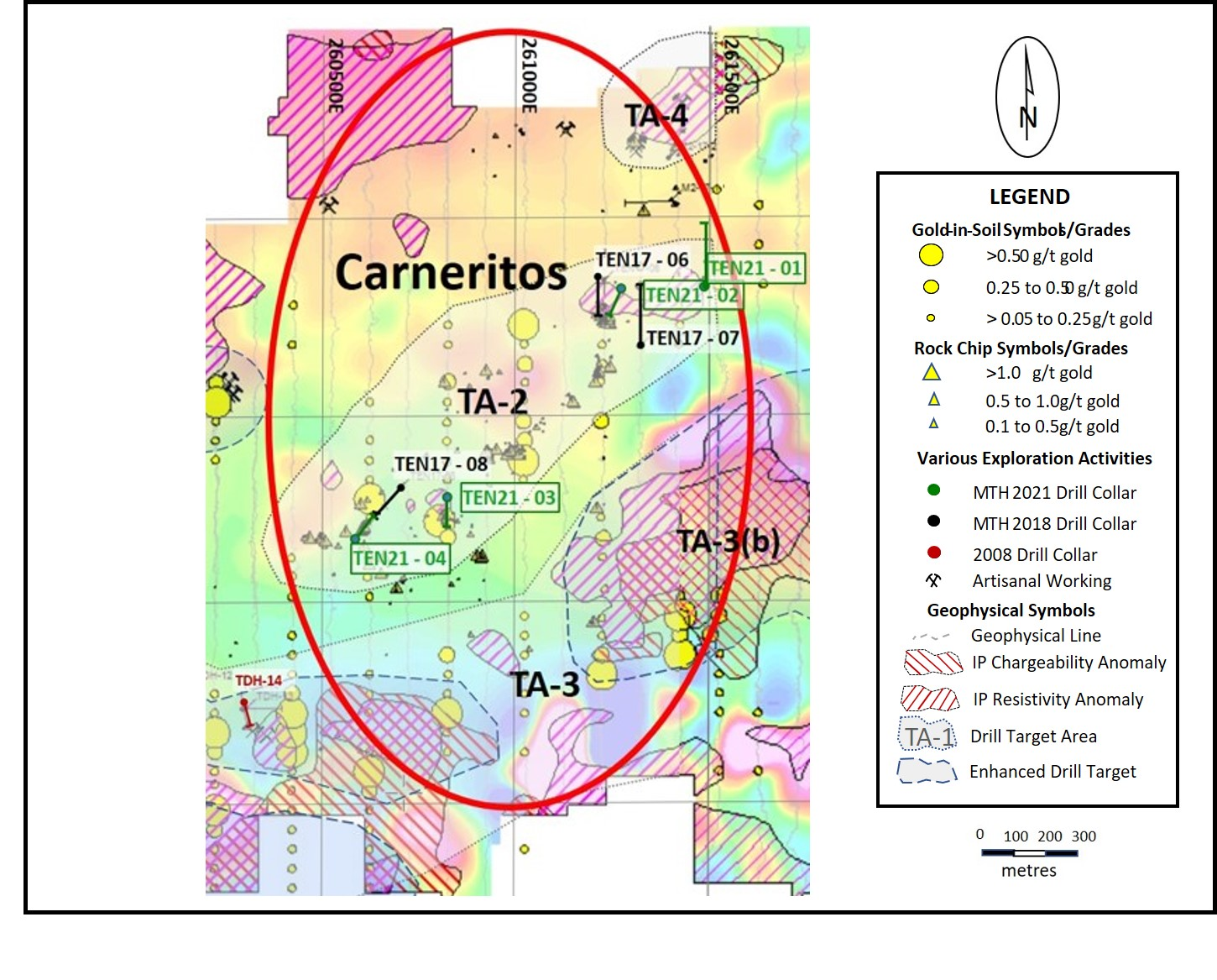
Four diamond drill holes have so far been completed for a total of426.0 metre testing the TA-2 target in the eastern portion (Carneritosarea) of the 4 km of gold-silver trend. The following table listspotentially economically mineralized intervals from this drilling(refer to Figure 1 - LocationMap, Tenoriba Property Drilling, 2021 (historic, TEN 2017 drill holes,plus TEN 2021 - 01 to TEN 2021 - 04 and Figure 2 - Location Map, Carneritos Area, Tenoriba PropertyDrilling, 2021 (historic, TEN 2017 drill holes plus TEN 2021 - 01 toTEN 2021 - 04).
| Hole |
| Weighted Average Gold |
| Weighted Average Silver |
| Weighted Average Gold Equivalent* |
| Location |
| Number |
| From |
| To |
| Total |
| Grade |
| Grade |
| Grade |
| (m) |
| (m) |
| (m) |
| (g/t) |
| (g/t) |
| (g/t) |
| Carneritos |
| TEN 21-01 |
| 7.5 |
| 45.0 |
| 37.5 |
| 0.31 |
| 17.1 |
| 0.53 |
| (including) |
| 36.0 |
| 40.5 |
| 4.5 |
| 0.47 |
| 75.2 |
| 1.47 |
| TEN 21-02 |
| No significant values |
| TEN 21-03 |
| 0.0 |
| 43.5 |
| 43.5 |
| 0.54 |
| 3.6 |
| 0.59 |
| (including) |
| 19.5 |
| 25.5 |
| 6.0 |
| 0.69 |
| 2.7 |
| 0.73 |
| (including) |
| 30.0 |
| 34.5 |
| 4.5 |
| 0.67 |
| 4.6 |
| 0.73 |
| TEN 21-04 |
| 0.0 |
| 19.5 |
| 19.5 |
| 0.53 |
| 7.3 |
| 0.63 |
Notes: Gold Equivalent wheresilver grade is converted to gold grade at 75 grams per tonne silver =1 gram per tonne gold.
Mammoth attempts to drill as near perpendicular asbelieved to be the orientation of mineralized control features,however lengths shown are core lengths versus perpendicular truelength of mineralized intersections.
Thomas Atkins, President and CEO ofMammoth commented on the initial results from the Tenoriba diamonddrill program stating: "We’re pleased that we can kick-off our 2021 drill program byreporting multi-tens of metre intervals of potentially economicalgold-silver mineralization at Tenoriba. This is especially so withinthe Carneritos target area, which measures approximately two by oneand a half kilometres and yet has only had three prior drill holestesting abundant surface gold-silver mineralization at depth. Thegrades of the intervals intersected by these drill holes comparefavourably to producing mines such as Agnico Eagle’s La India minein the Sierra Madre, Mexico, the reserve grade of which is 0.66 gramsper tonne gold reported in the most recent, 2020 reserve report. LaIndia, as an example is a similar High Sulphidation system toTenoriba, being mined by open pit with heap leach gold recovery,located in the same Sierra Madre belt as Tenoriba in Sonora State,Mexico.
“We began the drill program atCarneritos for a number of practical reasons, among which someincluded: Carneritos is located closest to a source of water fordrilling, we had decent access to Carneritos given we were frequentlyinundated by heavy rain during the rainy season, 74 percent of the 146chip samples collected in the area graded better than 0.3 grams pertonne gold equivalent and averaged over a gram of gold per tonne anddrill hole TEN 17 - 06 from Mammoth’s 2017/18 drill programintersected 127 metres grading 0.52 grams per tonne gold equivalent,including 58 metres grading 0.8 grams per tonne gold equivalent. Inaddition, given the size and prospective nature of the Carneritos areawe wanted to get some early results enabling us to return to the areaand perform follow up drilling.
“Results from this initial seriesof holes compare favourably to intervals from the prior three holes inthe area, expand two zones separated by over 500 metres, but yet to bedetermined whether connected and assist us in building upon theseintersections and further enhancing our understanding ofmineralization at Carneritos and throughout the entire 4-kilometretrend of gold-silver mineralization.”
Richard Simpson, Mammoth’s VicePresident Exploration further commented on these results,stating: “ D rilling to date in the Carneritos target area continues to returntens of metres of anomalous, near-surface gold-silver mineralization.Mineralized intervals are frequently oxidized and hosted by signatureHigh Sulphidation deposit type features, including dacitic porphyryand related brecciated rocks which have undergone advanced argillichydrothermal alteration characterized by the presence of alterationminerals such as illite, dickite, minor pyrophyllite, silica and vuggysilica typical of an epithermal, volcanic dome. The Carneritos arearemains very prospective and field assessment is underway analyzingdrill sections, surface geology, sampling and geophysics data, toassist in defining follow up drill locations on these targets withadditional drilling aimed at assisting in more clearly understandingthe size, orientation and controls to gold-silver mineralization atCarneritos.”
Drill Hole Description:
As previously discussed, Mammoth intends to initiallydrill 2 to 4 holes within each target zone then move to another targetzone to drill a similar number of holes (please refer to press releasedated July 22, 2021 for target zones). Company geologists will awaitthe results from initial drill holes testing target zones prior tofurther follow up drilling of these areas. Where mineralized intervalsare intersected in the initial sequence of drilling, or where holesfail to encounter mineralization as suggested by the data, follow updrilling will be based on field assessments combined with surfacegeology, sampling and geophysics data to assist in defining follow updrill collar locations with the aim of assisting in more clearlyunderstanding and testing the controls and continuity to gold-silvermineralization.
Drill Hole TEN 21 - 01
The hole was drilled to a depth of 199.5 m of a planned 150 to 200 mdepth at 55 degrees decline/dip and was collared approximately 280 meast of historical Mammoth drill hole TEN 17 - 06 and 250 m northeastof hole TEN 17 - 07. This drill hole was collared to test the depth extent of altered andmineralized porphyritic dacite and associated volcanic brecciaobserved on surface and in 2017 programdrill core. Advanced argillic alteration, including silica and patchyvuggy silica together with X-ray diffraction clay analysis showedpresence of dickite and pyrophyllite, common alteration clay mineralsin High Sulphidation systems, present in both surface and historicaldrill core near this target. There also appeared the potential of aburied sub-vertical moderately resistive I/P geophysical feature atdepth, which may have represented a mineralizing epithermal feederstructure.
Historic drill TEN 17 - 06 returned 129.75 m grading 0.46 g/t gold,4.23 g/t silver for 0.52 g/t gold equivalent (Eq) which returned 55 mgrading 0.19 g/t gold and 4,28 g/t silver (0.24 g/t gold Eq). Pleaserefer to Figure 1 and Figure 2 for drill hole locations.
The drill hole was successful in intersecting the mineralizedporphyritic dacite and associated breccia along 136 m core length ofwhich the first 27 m are strongly oxidized. This unit hosts amineralized zone from 7.5 to 45 m for a 37.5 m interval averaging 0.31grams per tonne (g/t) gold and 17.1 g/t silver for 0.53 g/t goldequivalent (Eq), including a 4.5 m interval grading 1.47 g/t gold Eq.This drill hole potentially extended the strike length of themineralized feature intersected in hole TEN 17 - 06 and TEN 17 - 07 byup to 250 m to the east.
Drill Hole TEN 21 - 02
The hole drilled to a depth of 88.5 mof a planned 50 to 100 m depth, at 60 degrees decline/dip and wascollared approximately 63 m southeast of hole TEN 17 - 06 and 120 mnorthwest of hole TEN 17 - 07 (refer to description Drill Hole TEN 21- 01 above for historic drill hole intervals and assay results). Thehole was collared approximately mid point between holes TEN 17 - 06and TEN 17 - 07. Please refer to Figure 1 and Figure 2 for drill hole locations.The control to mineralization present in these two holes wasinterpreted to be related by a west - northwest, near verticalstructure (suggested in part by 2014 geophysics survey) or to bestrata-bound with a shallow south to southeast dip, consistent withthe general strike and dip of the volcanic stratigraphy on theproperty.
After collaring in weathered, clay rich and oxidized porphyriticdacite down to 21.2 m and mixed oxide – sulfide down to 26.9 m, thehole remained in fresh unaltered dacite porphyry to the end of thehole at 88.5 m and did not intercept the interpreted possiblesub-vertical or strata bound mineralization control linking themineralized intercepts of holes TEN 17 - 06 and TEN 17 - 07 and it isbelieved that most likely the hole remained on a faulted block betweenthese two holes.
Drill Hole TEN 21 - 03
The hole was drilled to a depth of 79.5 m of aplanned 50 to 100 m depth, at 67 degrees decline/dip and was collared approximately 1 10 meast-southeast of historical drill hole TEN 17 - 08 . The hole was collared to test a surface, advancedargillic altered and surface mineralized dacite anddacitic breccia consisting of silica and patchy vuggy silicatogether with X-ray diffraction clay analysis showing presence ofdickite and pyrophyllite. Please refer to Figure 1 and Figure 2 for drill hole locations.These surface features are coincident with a strongnear-surface IP geophysics resistivity feature under recent artisanalexcavations where gold had been panned from soil and loose gravel.
The IP geophysics resistivity feature was the target ofhistorical Mammoth drill hole TEN 17 - 08. Hole TEN 17 - 08 returned14.9 m grading 0.58 g/t gold and 3.1 g/t silver (0.62 g/t gold Eq)however the targeted geophysical feature was never reached as the holewas abandoned prior to reaching the target due to poor groundconditions.
From the surface the hole remained in highly blocky,heavily oxidized variably altered silica and clay-rich breccia andporphyritic dacite rock with frequent poor core recovery until the endof the hole at 79.5 m. The first 43.5 m of the hole coincides with themineralized zone assaying 0.52 g/t gold, 4.1 g/t silver (0.59 g/t AuEq), including a 6.0 m interval grading 0.73 g/t gold Eq. Themineralized interval was followed by generally fresh unalteredporphyritic dacite to the bottom of the hole at 79.5 m. This drillhole potentially extended the mineralization encountered in hole TEN17 - 08 more than 100 m east.
Drill Hole TEN 21 - 04
The hole was drilled to a depth of 58.5 m of a targeted 150 to 200 mdepth, at 60 degrees decline/dip and was collared approximately 130 msouthwest of historical hole TEN 17 - 08. Please refer to Figure 1 and Figure 2 for drill hole locations. The hole was collared to test surface mineralizedporphyritic dacite and associated volcanic breccia outcrops andsub-crops of which various samples assayed above 1.0 g/t gold and where advanced argillic alteration, including silica and patchyvuggy silica together with X-ray diffraction clay analysis showed thepresence of dickite consistent with a moderate IPgeophysics resistivity feature at depth. This resistivity anomaly wasthe target of TEN17-08 as described above.
The hole intercepted from top to bottom porphyriticdacite. The first 50.8 m of hole TEN 21 - 04 is oxidized and highlyweathered with the exception of the first 21.0 m which is variably(weak to moderate) silicified and coincides with the mineralizedintercept in this hole returning 19.5 m grading 0.53 g/t gold and 7.3g/t silver (0.63 g/t gold Eq). This drill hole potentially extendedmineralization from 50 to 100 m west. The hole had to be abandonedprior to reaching its targeted depth because of poor ground conditionsdue to the high degree of alteration and oxidization of therock .
Qualified Person / QualityControls:
Richard Simpson, P.Geo., Vice-President Exploration forMammoth Resources Corp. is Mammoth's Qualified Person, according toNational Instrument 43-101 for the Tenoriba property and isresponsible for and has reviewed any technical data mentioned in thisnews release.
Samples referenced in this press release were preparedand analyzed by ALS laboratories (ALS) in their facilities in Mexicoand Canada, respectively. Samples generally consisted of a minimum of2 kilograms of material. Drill core is mostly HQ diameter core withminor lengths of NQ diameter core. Core is sawn in half with a rocksaw with one half used for sample analysis purposes. Where samples aretaken these are most often 1.5 metres in length, only in poor recoverysections do they exceed this length, with rare exceptions exceeding amaximum of 4.5 metres in length. Samples are collected with sampleticket and deposited into plastic sample bags sealed with nylon ziplock ties, then loaded into grain sacs similarly sealed with a nylonzip lock tie prior to transport by Mammoth personnel to ALS’sfacility in Chihuahua, Mexico for sample preparation. Gold and silveranalyses are performed in ALS’s facility in Canada via a 30-gramfire assay with an atomic absorption finish. Silver, copper, lead andzinc are analyzed as part of a multi-element ICP package using a4-acid digestion. Any over limit samples with greater than one percentcopper, lead and zinc are re-analyzed using ore grade detectionlimits. Blank and duplicate samples are inserted randomly atapproximately every 15 samples.
About Mammoth Resources:
Mammoth Resources (TSX-V: MTH) is a precious metalmineral exploration Company focused on acquiring and defining preciousmetal resources in Mexico and other attractive mining friendlyjurisdictions in the Americas. The Company holds a 100% interest(subject to a 2% net smelter royalty purchasable anytime within twoyears from commencement of commercial production for US$1.5 million)in the 5,333-hectare Tenoriba gold property located in the SierraMadre Precious Metal Belt in southwestern Chihuahua State, Mexico.Mammoth is seeking other opportunities to option exploration projectsin the Americas on properties it deems to host above average potentialfor economic concentrations of precious metalsmineralization.
To find out more about Mammoth Resources and to sign up to receivefuture press releases, please visit the company's website at: www.mammothresources.ca ., or contact Thomas Atkins, President andCEO at: 416 509-4326.
Neither the TSX Venture Exchange nor its RegulationServices Provider (as that term is defined in the policies of the TSXVenture Exchange) accepts responsibility for the adequacy or accuracyof this release.
Forward Looking Information: This news release maycontain or refer to forward-looking information. All information otherthan statements of historical fact that address activities, events ordevelopments that the Company believes, expects or anticipates will ormay occur in the future are forward-looking statements; examplesinclude the listing of its shares on a stock exchange and establishingmineral resources. These forward-looking statements are subject to avariety of risks and uncertainties beyond the Company's ability tocontrol or predict that may cause actual events or results to differmaterially from those discussed in such forward-looking statements.Any forward-looking statement speaks only as of the date on which itis made and, except as may be required by applicable securities laws,the Company disclaims any intent or obligation to update anyforward-looking statement, whether as a result of new information,future events or results or otherwise. Although the Company believesthat the assumptions inherent in the forward-looking statements arereasonable, forward-looking statements are not guarantees of futureperformance and, accordingly, undue reliance should not be placed onthese forward-looking statements due to the inherent uncertaintytherein.
.
Figure 1 – LocationMap, Tenoriba Property Drilling, 2021 (drill holes TEN 2021 - 01 toTEN 2021 - 04)
Figure 2 – LocationMap, Carneritos Area, Tenoriba Property Drilling, 2021 (drill holesTEN 2021 - 01 to TEN 2021 - 04)
Copyright (c) 2021 TheNewswire - All rights reserved.