NCM:CC - Newcrest Mining Limited - Quarterly Exploration Report - 30 September 2022
Growth potential advances across all regions as exploration portfolio expands
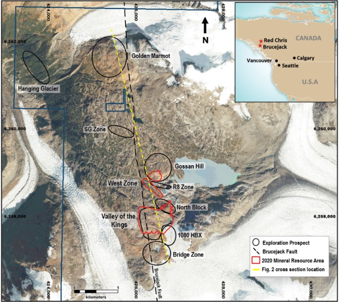
At Brucejack, drilling continues to confirm the potential for resource growth at the Valley of the Kings (VOK) deposit and the surrounding area with further high grade intercepts returned from the 1080 HBx Zone and Golden Marmot, which are located outside the current Pretium published resource.
At 1080 HBx Zone, drilling has expanded the VOK deposit and confirmed the continuity of the higher grade mineralisation at depth and to the south, with 22 of 44 holes returning intervals in excess of 5 grams per tonne gold. Drilling continues to deliver narrow intervals of very high grade gold mineralisation within broader zones of stockwork and vein arrays. Mineralisation now extends over 75m of strike and remains open. Results include, VU-4546, 22m @ 178g/t Au from 2m, including 1.0m @ 3,876g/t Au from 2m. In addition, VU-4331 returned 70.1m @ 35g/t Au from 337.5m, including 1.0m @ 2,310g/t Au from 361.5m.
At Golden Marmot, located approximately 3.5 km north of the Valley of the Kings, assays were received for the first 19 holes drilled during the quarter. Holes were drilled to infill the main zone, with 7 of 19 holes returning intervals in excess of 5 grams per tonne gold with results including, SU-888, 46.5m @ 16g/t Au from 66m, including 1m @ 488g/t Au from 77.5m and including 1m @ 236g/t Au from 99.5m. In addition, SU-879 returned 91.5m @ 9.1g/t Au from 100.5m, including 1.5m @ 514g/t Au from 138m.
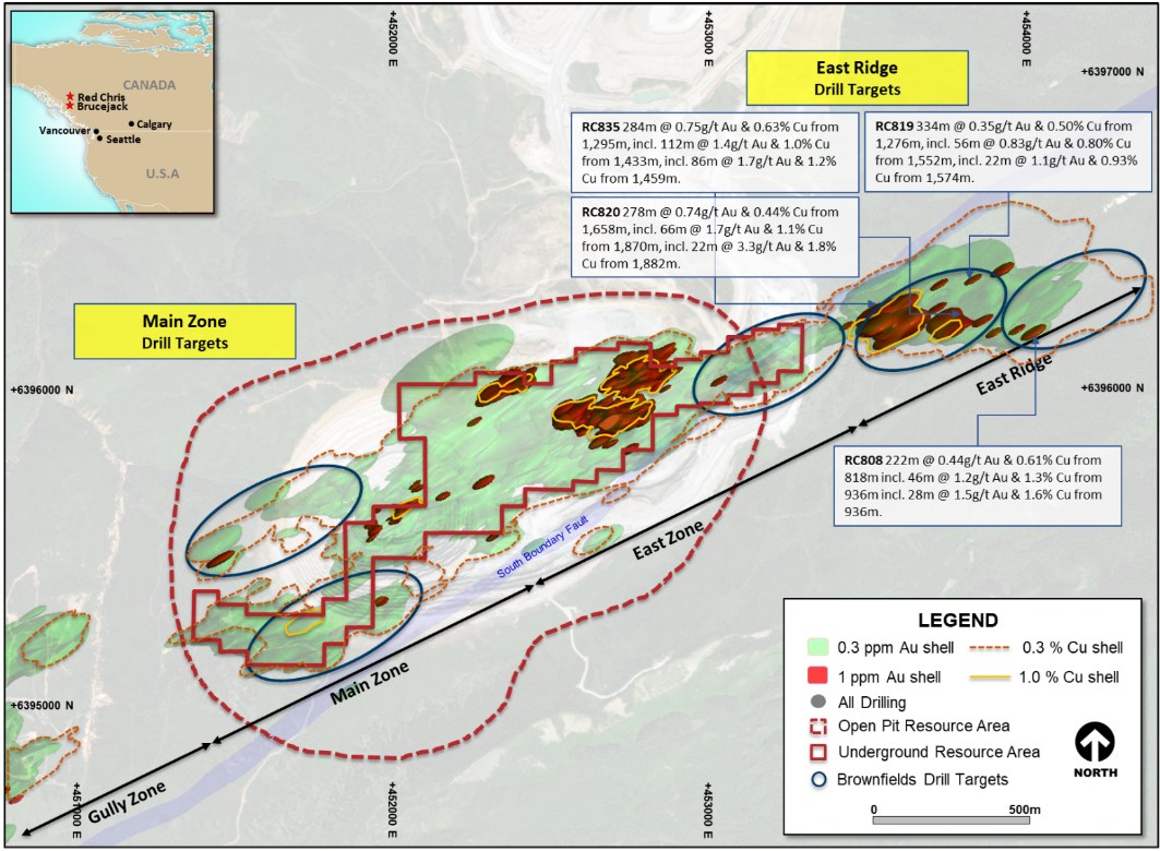
At Red Chris, ongoing drilling activities at East Ridge continue to confirm continuity and expand the footprint of higher grade mineralisation.
- At East Ridge, drilling has expanded the vertical extent of the mineralisation within the Exploration Target area previously reported on 21 July 2022. RC820 returned 278m @ 0.74g/t Au & 0.44% Cu from 1,658m, including 66m @ 1.7g/t Au & 1.1% Cu from 1,870m and RC835 returned 284m @ 0.75g/t Au & 0.63% Cu from 1,295m, including 112m @ 1.4g/t Au & 1.0% Cu from 1,433m. Both holes have extended higher grade mineralisation by a further 100m at depth to more than 600m vertical and both holes remain open at depth.
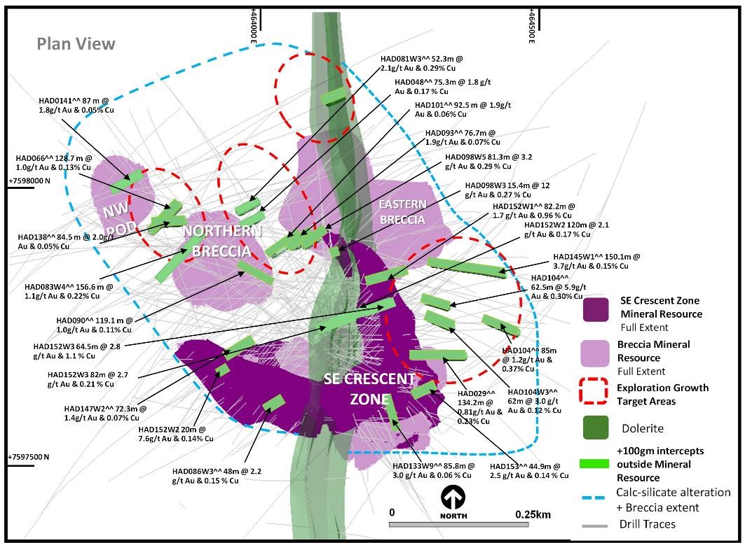
At Havieron, growth drilling continues to identify and expand high grade extensions to the mineralisation in the Eastern Breccia, South East Crescent Zone and Northern Breccia with potential for further incremental resource growth.
In the Eastern Breccia extensions to the southeast of the current Mineral Resource are reported including HAD152W2, 120m @ 2.1g/t Au & 0.17% Cu from 1,724m including 20.3m @ 3.1g/t Au & 0.68% Cu from 1,781.7m, HAD152W3, 64.5m @ 2.8g/t Au & 1.1% Cu from 1,798m including 13.5m @ 9.8g/t Au & 0.89% Cu from 1,843.5m and HAD104W3, 62m @ 3.0g/t Au & 0.12% Cu from 1,566m including 26.7m @ 6.4g/t Au & 0.16% Cu from 1,593m.
At the Northern Breccia a new zone of high grade sulphide mineralisation is being defined within the ~200m gap between the current Northern Breccia and Eastern Breccia Mineral Resource volumes. Results include HAD098W3, 15.4m @ 12 g/t Au & 0.27% Cu from 1,379.6m and HAD098W5, 81.3m @ 3.2g/t Au & 0.29% Cu from 1,357.2m including 53.3m @ 3.5g/t Au & 0.30% Cu from 1,360.5m. Drilling is ongoing to define the extents of this higher grade zone of mineralisation which is open to the northwest.
At the South East Crescent, drilling continues to demonstrate incremental growth at depth outside of the current Mineral Resource. Results include HAD086W5, 39.9m @ 4.6g/t Au & 0.10% Cu from 1,401.1m, including 20.6m @ 8.7g/t Au & 0.13% Cu from 1,403m, HAD086W6, 110m @ 1.7g/t Au & 0.16% Cu from 1,337m including 20.7m @ 4.4g/t Au & 0.10% Cu from 1,380.3m and HAD152W2, 20m @ 7.6g/t Au & 0.14% Cu from 1,453m.
Melbourne, Australia--(Newsfile Corp. - October 26, 2022) - Newcrest (ASX: NCM) (TSX: NCM) (PNGX: NCM) Managing Director and Chief Executive Officer, Sandeep Biswas, said, "Newcrest delivered another excellent quarter of exploration results with significant growth potential highlighted across our key targets at Brucejack, Red Chris and Havieron."
"At Brucejack we returned several high-grade intercepts during the quarter, supporting our views for significant resource growth potential. Golden Marmot remains open to the east, north, and south, with the target displaying many geological features of the nearby Valley of the Kings deposit."
"The results of our East Ridge discovery at Red Chris continue to expand the higher-grade footprint, and Havieron has continued to deliver encouraging results, demonstrating its potential for incremental growth outside of the current resource."
"We were also very pleased to expand our global exploration portfolio during the quarter with the addition of five new emerging projects in the highly prospective Great Basin Region in North America," said Mr Biswas.
Brucejack, British Columbia, Canada(1)
The Brucejack Property hosts the Valley of the Kings (VOK) high-grade gold deposit. The VOK is characterised by multiple occurrences of higher grade mineralisation over selected intervals hosted within broader zones of stockwork and vein arrays. Growth activities are focused on both resource expansion within the existing mine area, as well as brownfields exploration activities within 4km of the mine area. Both programs returned results of higher grade mineralisation during the period.
Resource expansion drilling during the quarter was focused on targets in the 1080 HBx Zone and Galena Hill. A total of 19,913m in 92 drill holes was completed using 3 underground drill rigs. Assay results were received for four drill fans in the 1080 HBx Zone. All other assays are pending.
Brownfields drilling during the quarter focused on targets in Gossan Hill South and Golden Marmot. A total of 23,731m in 55 drill holes was completed using 4 drill rigs on surface. During the quarter final assay results were received from the first 19 holes at Golden Marmot.
At 1080 HBx Zone, assays were received for 44 drill holes (four drill fans). All drill holes intersected gold mineralisation, with 22 of the 44 drill holes intersecting higher grade mineralisation, in excess of 5 grams per tonne. Drill holes at 1080 HBX are collared within the current Pretium published resource and are drilling in the resource for the initial 120 to 150 meters, depending on the orientation of the drill hole. The drill program was designed to follow up on the extensions of the high-grade gold mineralisation intersected in 1080 East drill program (previously reported).
Results have confirmed the continuity of higher grade gold mineralisation hosted in a zone oriented sub-parallel to Domain 20, which is currently being mined in the VOK. Drill fans were spaced at 15 meters horizontally in order to rapidly advance this new zone. Assays received to date cover an area of 75m x 300m x 250m. The 1080 HBX zone extends mineralisation an additional 150m south of the previous 1080 East drilling and gold mineralisation has now been intersected up to 225m south and 240m below the existing Mineral Resource estimate. Drilling is currently in progress to test the structure an additional 60 meters along strike to the west and an additional 15 meters along strike to the east.
Results for the reporting period include:
- VU-4331
- 70.1m @ 35g/t Au from 337.5m
- including 1m @ 2,310g/t Au from 361.5m
- VU-4340
- 25.63m @ 88g/t Au from 49.5m
- including 1m @ 2,100g/t Au from 50.5m
- VU-4529
- 38.5m @ 36g/t Au from 118.5m
- including 1m @ 1,315g/t Au from 156m
- VU-4546
- 22m @ 178g/t Au from 2m
- including 1m @ 3,876g/t Au from 2m
At Golden Marmot, assays were received for 19 drill holes. All drill holes intersected gold mineralisation, with 7 of the 19 drill holes intersecting higher grade gold mineralisation, in excess of 5 grams per tonne.
The focus for the 2022 drill program at Golden Marmot was to infill the main zone identified in 2021 and to step out from known mineralisation. Initial assays from the 2022 drill program have confirmed the presence of gold mineralisation over an area with dimensions of 100m wide, 200m long, and 300m high. The zone remains open to the east, north, south, and at depth. Mineralisation encountered at Golden Marmot displays many of the salient geological features that characterise hanging wall domains in the Valley of the Kings deposit immediately to the south. Future exploration drilling will focus on identifying controlling structures.
Results for the reporting period include:
- SU-873
- 12m @ 9.9g/t Au from 154.5m
- and 1m @ 3,010g/t Au from 269.5m
- SU-874
- 13.5m @ 25g/t Au from 148.5m
- including 1.5m @ 216g/t Au from 150m
- SU-875
- 10.5m @ 32g/t Au from 183m
- including 1m @ 328g/t Au from 190m
- SU-879
- 91.5m @ 9.1g/t Au from 100.5m
- including 1.5m @ 514g/t Au from 138m
- SU-888
- 46.5m @ 16g/t Au from 66m
- including 1m @ 488g/t Au from 77.5m
- including 1m @ 236g/t Au from 99.5m
- and 12.5m @ 6.9g/t Au from 180m
Approximately 54,000m of resource expansion drilling and 35,000m of brownfield exploration drilling targeting mineralisation definition and continuity are planned during calendar year 2022 with three drill rigs operating underground and four drill rigs operating on surface.
Refer to Appendix 1 for additional information, and the Drill hole data table for all results reported during the period.
Figure 1. Plan view map of the Brucejack Property, spanning the 4km gossanous trend from Golden Marmot and Hanging Glacier in the northwest to Bridge Zone in the southeast.
To view an enhanced version of Figure 1, please visit:
https://images.newsfilecorp.com/files/7614/142076_c8c59e7494a96824_003full.jpg
Figure 2. Long section view (looking west) of the Brucejack Property. Refer to figure 1 for the location of the cross section. Viewing window is +/- 150 meters.
To view an enhanced version of Figure 2, please visit:
https://images.newsfilecorp.com/files/7614/142076_c8c59e7494a96824_004full.jpg
Red Chris, British Columbia, Canada(2)
Red Chris is a joint venture between Newcrest (70%) and Imperial Metals Corporation (30%) and is operated by Newcrest.
The Brownfield Exploration program is focused on the discovery of additional zones of higher-grade mineralisation within the Red Chris porphyry corridor, including targets outside of Newcrest's Mineral Resource estimate. During the period, there were up to seven diamond drill rigs in operation. A further 20,926m of drilling has been completed from 27 drill holes, with all drill holes intersecting mineralisation. This contributed to a total of 286,300m of drilling from 278 drill holes since Newcrest acquired its interest in the joint venture in August 2019.
At East Ridge, located adjacent to the East Zone, drilling is ongoing with 63 holes completed and 6 in progress. The follow up drilling is being completed on a nominal 100m x 100m grid to determine the footprint and characterise the mineralisation, and to demonstrate the continuity of the higher-grade mineralisation. Drilling to date has tested a corridor 900m long and to a vertical extent of 1,000m within which zones of higher grade mineralisation have been identified.
East Ridge is outside of Newcrest's Mineral Resource estimate. Diamond drilling continues to define the extent and continuity of this higher grade mineralisation. A further 25 diamond drill holes are planned, at a minimum, to test and close out the target mineralisation. This program is expected to be completed by the second quarter of calendar year 2023.
Results for the reporting period include:
- RC808
- 222m @ 0.44g/t Au & 0.61% Cu from 818m
- including 46m @ 1.2g/t Au & 1.3% Cu from 936m
- including 28m @ 1.5g/t Au & 1.6% Cu from 936m
- RC813
- 298m @ 0.26g/t Au & 0.31% Cu from 446m
- including 52m @ 0.51g/t Au & 0.75% Cu from 458m
- RC819
- 334m @ 0.35g/t Au & 0.50% Cu from 1,276m
- including 56m @ 0.83g/t Au & 0.80% Cu from 1,552m
- including 22m @ 1.1g/t Au & 0.93% Cu from 1574m
- RC820
- 312m @ 0.49g/t Au & 0.49% Cu from 1,296m
- including 182m @ 0.64g/t Au & 0.64% Cu from 1,406m
- including 16m @ 1.7g/t Au & 1.2% Cu from 1,562m
- 278m @ 0.74g/t Au & 0.44% Cu from 1,658m
- including 66m @ 1.7g/t Au & 1.1% Cu from 1,870m
- including 22m @ 3.3g/t Au & 1.8% Cu from 1,882m
- RC835
- 284m @ 0.75g/t Au & 0.63% Cu from 1,295m
- including 112m @ 1.4g/t Au & 1.0% Cu from 1,433m
- including 86m @ 1.7g/t Au & 1.2% Cu from 1,459m
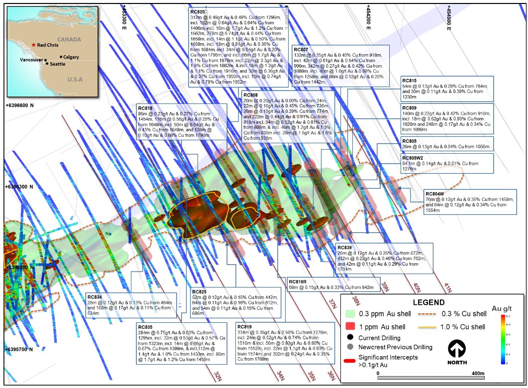
Drilling continues to expand the vertical extent of the East Ridge mineralisation. The latest drilling results from holes RC819, RC820 and RC835 extend the higher grade mineralisation by a further 100m at depth to more than 600m vertical. All holes remain open at depth.
These results demonstrate further support of the upside range of the Exploration Target defined in the June 2022 Quarterly Exploration Report dated 21 July 2022. The Exploration Target potential quantity and grade is conceptual in nature, there has been insufficient exploration to estimate a Mineral Resource and it is uncertain if further exploration will result in the estimation of a Mineral Resource.
Drilling within the Exploration Target area also continues to define the continuity of the higher grade mineralisation in hole RC808, located 100m above RC786 (previously reported).
The East Ridge mineralised corridor (>0.4g/t Au and >0.4% Cu) extends over 900m long, up to 1,000m high and 125m wide, with higher grade (>0.8g/t Au and >0.8% Cu) in several smaller pods over an area 500m high, 400m long and 100m wide.
Approximately 50,000m of growth-related drilling targeting mineralisation definition and continuity is planned for the first half of FY23 from eight drill rigs.
Refer to Appendix 2 for additional information, and the Drillhole data table for all results reported during the period.
Figure 3. Schematic plan view map of the Red Chris porphyry corridor spanning East Ridge, East Zone, Main Zone and Gully Zone showing significant Newcrest intercepts (drill intercepts have been reported in Appendix 2 of this report), 0.3g/t Au, 1g/t Au, 0.3% Cu and 1% Cu shell projections generated from a LeapfrogTM model.
To view an enhanced version of Figure 3, please visit:
https://images.newsfilecorp.com/files/7614/142076_c8c59e7494a96824_005full.jpg
Figure 4. Long section view (looking North West) of the Red Chris porphyry corridor showing drill hole locations, gold distribution and Exploration Target (previously released).
To view an enhanced version of Figure 4, please visit:
https://images.newsfilecorp.com/files/7614/142076_c8c59e7494a96824_006full.jpg
Havieron Project, Western Australia, Australia(3)
The Havieron Project is operated by Newcrest under a Joint Venture Agreement (JVA) with Greatland Gold. Newcrest is the manager and holds a 70% interest in the Havieron Project (Greatland Gold holds a 30% interest). The JVA includes tolling principles reflecting the intention of the parties that, subject to a successful exploration program, Feasibility Study and a positive decision to mine, the resulting joint venture mineralised material will be processed at Telfer.
The Havieron Project is centred on a deep magnetic anomaly located 45km east of Telfer in the Paterson Province. The deposit is overlain by more than 420m of post mineral Permian cover. The Joint Venture commenced drilling during the June 2019 quarter and has completed 269,585m of drilling from 327 drill holes to date (excluding holes in progress, abandoned holes, or drill holes which have not been sampled).
Drilling activities in the quarter have produced a further 20,345m of drilling from 21 holes with up to 6 drill rigs operating during the quarter. New assay results are reported from 20 drill holes (7 were assays pending from previous quarter). Of the reported holes, 11 holes returned significant assay intercepts in excess of 50 gram metres gold (Au ppm x length m).
Growth drilling targeting mineralisation definition and continuity continues to show potential for resource additions outside of the existing Indicated and Inferred Mineral Resource limits, including:
- Extensions of the Eastern Breccia including definition of identified internal higher grade zones - assay results reported for 8 drill holes, 3 holes awaiting assays.
- Extensions to the Northern Breccia at depth between the current Northern Breccia Resource and Eastern Breccia Resource - assay results reported for 4 drill holes, 2 holes awaiting assays.
- Extension of the South East Crescent at depth below the current Mineral Resource - assay results reported for 5 drill holes.
- Drilling is continuing to target geophysical targets outside of the main Havieron system - 3 drill holes results reported and 4 holes awaiting assays from step out drilling north and south of the Havieron system.
At the Eastern Breccia, assays for 8 holes targeting strike and depth extensions from previously reported drill holes have been received, with 3 holes awaiting assays. The Eastern Breccia is developed below the 4,100RL with a footprint of over 500m in strike, up to 200m in width, and over 250m in vertical extent. Within this zone multiple northwest trending internal higher-grade (>1 g/t Au) sulphide dominated domains are observed. The Eastern Breccia remains open at depth and to the northwest and southeast.
Results for the quarter further highlight geological continuity within the Eastern Breccia with results extending the high grade zones ~170m to the southeast of the current Eastern Breccia Mineral Resource. Drilling within the Eastern Breccia footprint is ongoing to confirm the continuity of internal higher grade sulphide zones.
Results include:
- HAD104W3
- 62m @ 3.0g/t Au & 0.12% Cu from 1,566m.
- including 26.7m @ 6.4g/t Au & 0.16% Cu from 1,593m.
- HAD145AW5
- 168m @ 0.69g/t Au & 0.27% Cu from 1,623m.
- including 11.3m @ 2.4g/t Au & 0.53% Cu from 1,686m.
- 38m @ 1.9g/t Au & 0.17% Cu from 2,038m.
- including 23m @ 2.5g/t Au & 0.16% Cu from 2,053m.
- HAD152W2
- 120m @ 2.1g/t Au & 0.17% Cu from 1,724m.
- including 20.3m @ 3.1g/t Au & 0.68% Cu from 1,781.7m.
- HAD152W3
- 82m @ 2.7g/t Au & 0.21% Cu from 1,695m.
- 64.5m @ 2.8g/t Au & 1.1% Cu from 1,798m.
- including 13.5m @ 9.8g/t Au & 0.89% Cu from 1,843.5m.
At the Northern Breccia a new zone of high grade sulphide mineralisation is being defined within the ~200m gap between the current Northern Breccia and Eastern Breccia Mineral Resource volumes. This new zone originally intercepted in HAD093^^, 76.7m @ 1.9 g/t Au & 0.07 % Cu from 1,306.13m including 18.2m @ 10 g/t Au & 0.17 % Cu from 1,347.8m and HAD101^^ 92.5 m @ 1.9g/t Au & 0.06% Cu from 1,296m has now been defined over a NW trending strike length of 100m in HAD098W2, HAD098W3 and HAD098W5, and remains open to the northwest. Drilling is ongoing to define the extents of this higher grade zone of mineralisation with the potential to provide incremental resource growth.
Results include:
- HAD098W2
- 27m @ 1.9g/t Au & 0.19% Cu from 1,170m.
- including 12m @ 3.7g/t Au & 0.26% Cu from 1,178m.
- 39.3m @ 2.1g/t Au & 0.12% Cu from 1,335.7m.
- 20.7m @ 3.6 g/t Au & 0.43 % Cu from 1,387.3m.
- HAD098W3
- 15.4m @ 12 g/t Au & 0.27% Cu from 1,379.6m.
- HAD098W5
- 106.2m @ 0.78g/t Au & 0.12% Cu from 1,114.7m.
- 81.3m @ 3.2g/t Au & 0.29% Cu from 1,357.2m.
- including 53.3m @ 3.5g/t Au & 0.30% Cu from 1,360.5m.
South East Crescent growth drilling continued during the quarter targeting higher grade mineralisation at depth below the current Mineral Resource. Results were received from 5 drill holes indicating an extension of Crescent style mineralisation up to 100m to the northwest of the current Mineral Resource between 4,100mRL and 4,000mRL. Additionally, HAD153W2 extended Crescent style mineralisation ~100m to the west of the current South East Crescent Mineral Resource on the 3,900mRL.
Results include:
- HAD086W5
- 39.9m @ 4.6g/t Au & 0.10% Cu from 1,401.1m.
- including 20.6m @ 8.7g/t Au & 0.13% Cu from 1,403m.
- 41.9m @ 1.7g/t Au & 0.11% Cu from 1,491.8m.
- including 16.1m @ 3.9g/t Au & 0.12% Cu from 1,512m.
- HAD086W6
- 110m @ 1.7g/t Au & 0.16% Cu from 1,337m.
- including 12.9m @ 3.5g/t Au & 0.49% Cu from 1,356.1m
- including 20.7m @ 4.4g/t Au & 0.10% Cu from 1,380.3m.
- HAD152W2
- 20m @ 7.6g/t Au & 0.14% Cu from 1,453m.
- including 16m @ 9.4g/t Au & 0.17% Cu from 1,455m.
- HAD153W2
- 21.5m @ 3.0g/t Au & 0.22% Cu from 1,663.5m.
Testing for system depth extents, HAD156 successfully intersected mineralisation 450m below the current Mineral Resource extents on the 3,400mRL returning 30m @ 1.5g/t Au & 0.18% Cu from 2,079m. Further analysis is required to confirm if this intercept links up to the South East Crescent, or Eastern Breccia, or if it is a separate zone, but it demonstrates the Havieron mineralised system has the potential to extend over 1,450m from the base of the Permian cover sequence.
Drilling to test geophysical targets outside of the known Havieron mineralised system, including evaluating the Havieron dolerite at multiple intervals north and south of the Havieron mineralised envelope revealed no significant intercepts from three drill holes (HAD157, HAD158 and HAD160). Three additional holes are awaiting assays.
Ongoing drilling is planned for the Eastern Breccia, Northern Breccia and camp scale targets external to the Havieron mineralised footprint.
Refer to Appendix 3 for additional information and Drillhole data table for all results reported during the period.
Figure 5. 3D Plan view schematic showing the spatial association of the South East Crescent, Northern Breccia, North West Pod and Eastern Breccia in relation to the current exploration growth target areas and the Mineral Resource extents. Also highlighted are selected previously reported^^ and new intercepts >100 gram metres (Au ppm x length) that have been intersected outside of the Inferred Mineral Resource. Intercepts are projected to the 4600RL.
To view an enhanced version of Figure 5, please visit:
https://images.newsfilecorp.com/files/7614/142076_c8c59e7494a96824_007full.jpg
Figure 6. 3D oblique view of the Havieron system viewed from the south-east, showing the position of high-grade intercepts (previously^^ reported and new) and mineralised zones >100 gram metres (Au ppm x length) that have been intersected outside of the Mineral Resource extents. Further higher-grade mineralisation and assay results continue to support incremental expansion of the Northern Breccia and Southeast Crescent, as well as extensions to the Eastern Breccia (refer to Figure 5 for spacial relationship of drill holes and zones).
To view an enhanced version of Figure 6, please visit:
https://images.newsfilecorp.com/files/7614/142076_c8c59e7494a96824_008full.jpg
Figure 7. Plan view schematic of a horizontal slice at 3900mRL through the Crescent Sulphide Zone and Breccia-hosted Zones, showing the extents of the 0.5 and 1.0 g/t Au LeapfrogTM grade shells with highlighted newly reported intercepts for this period. This diagram highlights >50 gram metres intersections drilled during the period, refer to inset diagram for relationship to all Havieron drilling.
To view an enhanced version of Figure 7, please visit:
https://images.newsfilecorp.com/files/7614/142076_c8c59e7494a96824_009full.jpg
Wilki Project, Western Australia, Australia
The Wilki Project is an exploration farm-in and joint venture with Antipa Minerals Limited (Antipa). The project area covers a strategic landholding of ~2,200km2 surrounding the Telfer operation and is adjacent to the Havieron Project. Newcrest entered into this exploration farm-in and joint venture agreement with Antipa on 11 March 2020. Newcrest currently also has a 9.9% shareholding in Antipa.
As previously highlighted, Newcrest has elected to proceed to the next stage (Stage 1) of the farm-in agreement following completion of the initial exploration expenditure commitment (A$6 million). Newcrest has the potential to earn a 51% joint venture interest in the Wilki Project through expenditure of a further A$10 million by March 2025 during Stage 1. As of 1 July 2022, Newcrest is now the manager and operator of the Wilki Project.
Cultural clearance activities commenced over priority areas during the quarter allowing access for soil sampling and follow up drilling will be ready for execution on completion of access.
Juri Joint Venture, Western Australia, Australia
The Juri Joint Venture is a farm-in and joint venture agreement with Greatland Gold with respect to the Black Hills and Paterson Range East projects, located within the Paterson Province approximately 50km from the Telfer operation and in proximity to the Havieron Project. The joint venture covers an area of approximately 248km2. Newcrest currently has a 51% interest in the Juri Joint Venture. Under the terms of the agreement, Newcrest has the potential to earn an additional 24% joint venture interest through expenditure of a further A$17 million by October 2024.
Drilling was completed at the A9 target and the initial hole of a planned two hole program was completed at Tama. Assay results are currently pending. Further work will be focused on the A27 anomaly in Black Hills region.
Western USA
During the quarter Newcrest entered into agreements with two separate companies in the Great Basin Region in North America. The Great Basin is a prospective region for gold deposits of multiple types including epithermal deposits.
Newcrest entered into four separate definitive option and earn-in agreements with Headwater Gold Inc. (Headwater Gold) and purchased a 9.9% equity interest in the company. Newcrest has the option to acquire up to a 75% interest individually in each of Headwater Gold's Agate Point, Midas North and Spring Peak Projects in Nevada and the Mahogany Project in Oregon. At Spring Peak, preparation is underway for diamond and RC drilling in the December 2022 quarter to follow up on promising gold intercepts completed by Headwater Gold in late 2021. Target definition work is currently underway at Midas North.
Newcrest has also signed an option and earn-in agreement with Gunpoint Exploration Ltd. (Gunpoint) to acquire up to 75% of the Appaloosa property located in Nevada, USA (with an option to acquire the remaining 25% of Appaloosa post the earn-in period). Appaloosa is an underexplored mineralised structural zone situated within Gunpoint's Talapoosa gold-silver project. Newcrest is currently performing target definition work including mapping, geophysics and rock chip and channel sampling.
Central Andes, Northern Chile
During the September 2022 quarter, Newcrest provided notice to Mirasol Resources and Cornerstone Capital Resources to terminate the earn-in agreements at the Gorbea and Mioceno projects, respectively.
Northern Andes, Ecuador
Planning is in progress for the second phase of scout drilling at the Gamora Project, located in southeast Ecuador. This work is being conducted by Newcrest as the operator under an earn-in agreement with Lundin Gold Inc. (Lundin Gold) pursuant to which Newcrest can earn up to a 50% interest in eight exploration concessions. The concession area covers strategic landholdings to the north and south of Lundin Gold's Fruta del Norte mining operation. The next phase of drilling at Gamora will focus on testing priority copper-gold porphyry targets starting in the December 2022 quarter.
Appendix 1
Brucejack (100% Newcrest): JORC Table 1
Section 1: Sampling Techniques and Data
| Criteria |
| Commentary |
| Mineral tenement and land tenure status |
| Brucejack comprises 346 mineral tenures including four mining leases and is 100% owned by Newcrest Mining Limited. All obligations with respect to legislative requirements including minimum expenditure are maintained in good standing. |
| Exploration done by other parties |
| Granduc, Esso, Newhawk, Lacana Mining Corp., and Silver Standard conducted exploration in the area between 1960 and 2010. Pretium Resources acquired the Brucejack Property in 2010 and drilled the discovery hole at the Valley of the Kings in 2011. North Block and 1080 level were first drilled in 2020. Golden Marmot was previously drilled in 1988 and 2011. |
| Geology |
| The Brucejack Project is located in the Stikine terrane of north-western British Columbia, 50 km north of the town of Stewart. Early Jurassic sedimentary and volcanic rocks of the Lower Hazelton Group host mineralisation. A pervasive quartz-pyrite-sericite alteration event predates the main stage of epithermal mineralisation. Gold mineralisation at Brucejack consists of electrum hosted in vein stockworks, sheeted veins, and veinlets. |
| Drill hole information |
| As provided. |
| Data aggregation methods |
| Significant assay intercepts are reported as length-weighted averages exceeding 0.6g/t Au greater than or equal to 10m, with less than 7.5m of consecutive internal dilution. Also reported are intervals greater than 150g/t Au. Intervals below a cutoff of 1.0gt Au were not reported as significant results. No top cuts are applied to intercept calculations. |
| Relationship between mineralisation widths and intercept lengths |
| Significant assay intervals reported represent apparent widths. Insufficient geological information is available to confirm the geological model and true width of significant assay intervals. |
| Diagrams |
| As provided. |
| Balanced reporting |
| This is the third release of Exploration Results for this project made by Newcrest. Exploration results have been reported by Newcrest since April 2022. Exploration drilling programs are ongoing and further material results will be reported in subsequent Newcrest releases. |
| Other substantive exploration data |
| Nil. |
| Further work |
| Drilling is currently underway at 1080 HBx to complete the remaining 5 drill fans in the program. . Follow up drilling is also being planned for the Bridge Zone, Eastern Promises, and West VOK. |
Drillhole data(1)
Brucejack, British Columbia, Canada
Reporting Criteria: Intervals are reported as length-weighted averages exceeding 0.6g/t Au greater than or equal to 10m, with less than 7.5m of consecutive internal dilution. Also reported are intervals greater than 150g/t Au. Intervals below a cutoff of 1.0gt Au were not reported as significant results. Samples are from core drilling which is HQ in diameter. Core is photographed and logged by the geology team before being whole core sampled and sent for assay. Each assay batch is submitted with duplicates and standards to monitor laboratory quality.
| Hole ID |
| Hole Type |
| Easting (m) |
| Northing (m) |
| RL (m) |
| Total Depth (m) |
| Azimuth |
| Dip |
| From (m) |
| To (m) |
| Interval (m) |
| Au (ppm) |
| Cut off |
| Sampling techniques |
| Core samples are obtained from core drilling. HQ and NQ diameter diamond core was drilled on a 3, 4.5m or 6m run. Core was cut using an automatic core-cutter and half core sampled at 2m intervals. Cover sequences were not sampled. |
| Drilling techniques |
| Core drilling was advanced with HQ3, HQ, NQ3 and NQ diameter coring configuration. Core from inclined drill holes are oriented on 3, 4.5m or 6m runs using an electronic core orientation tool (Reflex ACTIII). At the end of each run, the bottom of hole position is marked by the driller, which is later transferred to the whole drill core run length with a bottom of hole reference line. |
| Drill sample recovery |
| Core recovery is systematically recorded from the commencement of coring to end of hole, by reconciling against driller's depth blocks in each core tray with data recorded in the database. Drillers depth blocks provided the depth, interval of core recovered, and interval of core drilled. Core recoveries were typically 100%, with isolated zones of lower recovery. |
| Logging |
| Geological logging recorded qualitative descriptions of lithology, alteration, mineralisation, veining, and structure (for all core drilled - 20,925.8m in 27 holes - all holes intersected mineralisation, including orientation of key geological features). Geotechnical measurements were recorded including Rock Quality Designation (RQD) fracture frequency, solid core recovery and qualitative rock strength measurements. Magnetic susceptibility measurements were recorded every metre. All geological and geotechnical logging was conducted at the Red Chris Mine. Digital data logging was captured, validated and stored in an acQuire database. All drill cores were photographed, prior to cutting and/or sampling the core. |
| Sub-sampling techniques and sample preparation |
| Sampling, sample preparation and quality control protocols are considered appropriate for the material being sampled. Core was cut and sampled at the Red Chris Mine core processing facility. Half core samples were collected in plastic bags together with pre-numbered sample tags and grouped in wood crates for dispatch to the laboratory. Sample weights typically varied from 5 to 10kg. Sample sizes are considered appropriate for the style of mineralisation. Drill core samples were freighted by road to the laboratory. Sample preparation was conducted at the independent ISO 9001 certified and ISO 17025 accredited Bureau Veritas Commodities Canada Ltd Laboratory, Vancouver (Bureau Veritas). Samples were dried at 650C, and crushed to 95% passing 4.75 mm, and the split to obtain up to 1kg sub-sample, which was pulverised (using LM2) to produce a pulped product with the minimum standard of 95% passing 106?m. Duplicate samples were collected from crush and pulp samples at a rate of 1:20. Duplicate results show an acceptable level of variability for the material sampled and style of mineralisation. Periodic size checks (1:20) for crush and pulp samples and sample weights are provided by the laboratory and recorded in the acQuire database. |
| Quality of assay data and laboratory tests |
| Assaying of drill core samples was conducted at Bureau Veritas. All samples were assayed for 59 elements using a 4-acid digestion followed by ICP-AES/ICP-MS determination (method MA250). Gold analyses were determined by 50g fire assay with ICP-ES finish (method FA350). Carbon and Sulphur were determined by Leco (method TC000) and mercury using aqua regia digestion followed by ICP-ES/MS determination (method AQ200). Sampling and assaying quality control procedures consisted of inclusion of certified reference material (CRMs), coarse residue and pulp duplicates with each batch (at least 1:20). Assays of quality control samples were compared with reference samples in the acQuire database and verified as acceptable prior to use of data from analysed batches. Laboratory quality control data, including laboratory standards, blanks, duplicates, repeats and grind size results are captured in the acQuire database and assessed for accuracy and precision for recent data. Due to the limited extent of the drilling program to date, extended quality control programs are yet to be undertaken, whereby pulped samples will be submitted to an umpire laboratory and combined with more extensive re-submission programs. Analysis of the available quality control sample assay results indicates that an acceptable level of accuracy and precision has been achieved and the database contains no analytical data that has been numerically manipulated. The assaying techniques and quality control protocols used are considered appropriate for the data to be used for reporting exploration drilling results. |
| Verification of sampling and assaying |
| Sampling intervals defined by the geologist are electronically assigned sample identification numbers prior to core cutting. Corresponding sample numbers matching pre-labelled sample tags are assigned to each interval. All sampling and assay information were stored in a secure acQuire database with restricted access. Electronically generated sample submission forms providing the sample identification number accompany each submission to the laboratory. Assay results from the laboratory with corresponding sample identification are loaded directly into the acQuire database. Assessment of reported significant assay intervals was verified by re-logging of drill core intervals and assessment of high resolution core photography. The verification of significant intersections has been completed by company personnel and the Competent Person/Qualified Person. No adjustments are made to assay data, and no twinned holes have been completed. Drilling intersects mineralisation at various angles. There are no currently known drilling, sampling, recovery, or other factors that could materially affect the accuracy or reliability of the data. |
| Location of data points |
| Drill collar locations were surveyed using a RTK GPS with GNSS with a stated accuracy of +/- 0.025m. Drill rig alignment was attained using an electronic azimuth aligner (Reflex TN14 GYROCOMPASS). Downhole survey was collected at 9 to 30m intervals of the drill hole using single shot survey (Reflex EZ-SHOT). At the end of hole, all holes have been surveyed using a continuous gyro survey to surface (Reflex EZ-GYRO). Topographic control is established from PhotoSat topographic data and derived digital elevation model. The topography is generally low relief to flat, with an average elevation of 1500 m, with several deep creek gullies. All collar coordinates are provided in the North American Datum (NAD83 Zone 9). |
| Data spacing and distribution |
| The drill hole spacing ranges from 100 - 200m in lateral extent within an area of 1.5km2 at the East Ridge, 1.5km2 at the East Zone, 1.5km2 at the Main Zone and 1.5km2 at the Gully Zone. An initial Mineral Resource for the East Zone, Main Zone and Gully Zone was released on 31 March 2021. No sample compositing is applied to samples. |
| Orientation of data in relation to geological structure |
| Drilling of reported drill holes RC804W, RC805, RC805W2, RC807, RC808, RC809, RC811, RC813, RC814, RC815, RC816R, RC818, RC819, RC820, RC822, RC825, RC832, RC834, RC835, RC839 and RC844 are oriented perpendicular to the intrusive complex. The intrusive complex has an east-northeast orientation, with drilling established on a north-northwest orientation. Drill holes exploring the extents of the East Ridge, East Zone, Main Zone and Gully Zone mineral system intersected moderately dipping volcanic and sedimentary units cut by sub-vertical intrusive lithologies. Steeply dipping mineralised zones with an east-northeast orientation have been interpreted from historic and Newcrest drill holes. |
| Sample security |
| The security of samples is controlled by tracking samples from drill rig to database. Drill core was delivered from the drill rig to the Red Chris Mine core yard every shift. Geological and geotechnical logging, high resolution core photography and cutting of drill core was undertaken at the Red Chris core processing facility. Samples were freighted in sealed bags with security tags by road to the laboratory, and in the custody of Newcrest representatives. Sample numbers are generated from pre-labelled sample tags. All samples are collected in pre-numbered plastic bags. Sample tags are inserted into prenumbered plastic bags together with the sample. Verification of sample numbers and identification is conducted by the laboratory on receipt of samples, and sample receipt advice issued to Newcrest. Details of all sample movement are recorded in a database table. Dates, Hole ID sample ranges, and the analytical suite requested are recorded with the dispatch of samples to the laboratory analytical services. Any discrepancies logged at the receipt of samples into the laboratory analytical services are validated. |
| Audits or reviews |
| Due to the limited duration of the program, no external audits or reviews have been undertaken. Internal verification and audit of Newcrest exploration procedures and databases are periodically undertaken. |
Section 2: Reporting of Exploration Results
| Criteria |
| Commentary |
| RC804W |
| DD? |
| 453877 |
| 6396985 |
| 1342 |
| 1684.2 |
| 147 |
| -57 |
| 1458 |
| 1534 |
| 76 |
| 0.12 |
| 0.35 |
| 0.1 |
| 1554 |
| 1618 |
| 64 |
| 0.12 |
| 0.34 |
| 0.1 |
| RC805 |
| DD? |
| 453731 |
| 6396989 |
| 1364 |
| 1133.5 |
| 144 |
| -58 |
| 1056 |
| 1082 |
| 26 |
| 0.13 |
| 0.04 |
| 0.1 |
| RC805W2 |
| DD? |
| 453731 |
| 6396989 |
| 1364 |
| 1330.1 |
| 144 |
| -58 |
| 1276 |
| 1330.1 |
| 54.1 |
| 0.14 |
| 0.51 |
| 0.1 |
| RC807 |
| DD? |
| 453758 |
| 6396761 |
| 1375 |
| 1619.4 |
| 148 |
| -58 |
| 918 |
| 1050 |
| 132 |
| 0.35 |
| 0.40 |
| 0.1 |
| incl. |
| 990 |
| 1032 |
| 42 |
| 0.61 |
| 0.54 |
| 0.5 |
| 1088 |
| 1430 |
| 342 |
| 0.27 |
| 0.42 |
| 0.1 |
| incl. |
| 1258 |
| 1298 |
| 40 |
| 1.0 |
| 0.88 |
| 0.5 |
| 1442 |
| 1528 |
| 86 |
| 0.12 |
| 0.20 |
| 0.1 |
| RC808 |
| DD? |
| 453753 |
| 6396582 |
| 1394 |
| 1442.0 |
| 148 |
| -55 |
| 24 |
| 44 |
| 20 |
| 0.20 |
| 0.00 |
| 0.1 |
| 736 |
| 758 |
| 22 |
| 0.16 |
| 0.45 |
| 0.1 |
| 774 |
| 800 |
| 26 |
| 0.10 |
| 0.29 |
| 0.1 |
| 818 |
| 1040 |
| 222 |
| 0.44 |
| 0.61 |
| 0.1 |
| incl. |
| 888 |
| 922 |
| 34 |
| 0.52 |
| 0.81 |
| 0.5 |
| incl. |
| 936 |
| 982 |
| 46 |
| 1.2 |
| 1.3 |
| 0.5 |
| incl. |
| 936 |
| 964 |
| 28 |
| 1.5 |
| 1.6 |
| 1 |
| RC809 |
| DD? |
| 453826 |
| 6396816 |
| 1352 |
| 1812.2 |
| 146 |
| -56 |
| 910 |
| 1050 |
| 140 |
| 0.22 |
| 0.42 |
| 0.1 |
| incl. |
| 1020 |
| 1038 |
| 18 |
| 0.52 |
| 0.93 |
| 0.5 |
| 1098 |
| 1346 |
| 248 |
| 0.17 |
| 0.34 |
| 0.1 |
| RC811 |
| DD? |
| 451453 |
| 6395327 |
| 1524 |
| 1043.3 |
| 147 |
| -71 |
| 14 |
| 120 |
| 106 |
| 0.14 |
| 0.02 |
| 0.1 |
| 152 |
| 192 |
| 40 |
| 0.11 |
| 0.04 |
| 0.1 |
| 222 |
| 518 |
| 296 |
| 0.44 |
| 0.29 |
| 0.1 |
| incl. |
| 278 |
| 290 |
| 12 |
| 0.62 |
| 0.33 |
| 0.5 |
| incl. |
| 338 |
| 464 |
| 126 |
| 0.62 |
| 0.39 |
| 0.5 |
| 536 |
| 850 |
| 314 |
| 0.23 |
| 0.25 |
| 0.1 |
| 926 |
| 1014 |
| 88 |
| 0.14 |
| 0.19 |
| 0.1 |
| RC813 |
| DD? |
| 451622 |
| 6395868 |
| 1529 |
| 1198.4 |
| 151 |
| -54 |
| 216 |
| 238 |
| 22 |
| 0.11 |
| 0.13 |
| 0.1 |
| 322 |
| 398 |
| 76 |
| 0.25 |
| 0.31 |
| 0.1 |
| 446 |
| 744 |
| 298 |
| 0.26 |
| 0.31 |
| 0.1 |
| incl. |
| 458 |
| 510 |
| 52 |
| 0.51 |
| 0.75 |
| 0.5 |
| 796 |
| 816 |
| 20 |
| 0.17 |
| 0.13 |
| 0.1 |
| 852 |
| 1198.4 |
| 346.4 |
| 0.31 |
| 0.33 |
| 0.1 |
| incl. |
| 910 |
| 944 |
| 34 |
| 0.58 |
| 0.37 |
| 0.5 |
| RC814 |
| DD? |
| 451528 |
| 6396040 |
| 1529 |
| 1289.4 |
| 149 |
| -57 |
| 404 |
| 426 |
| 22 |
| 0.11 |
| 0.04 |
| 0.1 |
| 486 |
| 754 |
| 268 |
| 0.25 |
| 0.20 |
| 0.1 |
| incl. |
| 606 |
| 616 |
| 10 |
| 0.71 |
| 0.39 |
| 0.5 |
| 930 |
| 1020 |
| 90 |
| 0.21 |
| 0.13 |
| 0.1 |
| 1100 |
| 1282 |
| 182 |
| 0.22 |
| 0.25 |
| 0.1 |
| RC815 |
| DD? |
| 453889 |
| 6396750 |
| 1347 |
| 1634.0 |
| 149 |
| -54 |
| 764 |
| 818 |
| 54 |
| 0.13 |
| 0.29 |
| 0.1 |
| 1230 |
| 1260 |
| 30 |
| 0.11 |
| 0.39 |
| 0.1 |
| RC816R |
| DD? |
| 453753 |
| 6396582 |
| 1394 |
| 1257.9 |
| 149 |
| -48 |
| 842 |
| 910 |
| 68 |
| 0.15 |
| 0.33 |
| 0.1 |
| RC818 |
| DD? |
| 453208 |
| 6396916 |
| 1464 |
| 2019.8 |
| 146 |
| -60 |
| 1454 |
| 1540 |
| 86 |
| 0.23 |
| 0.27 |
| 0.1 |
| 1648 |
| 1764 |
| 116 |
| 0.56 |
| 0.25 |
| 0.1 |
| incl. |
| 1648 |
| 1698 |
| 50 |
| 0.64 |
| 0.43 |
| 0.5 |
| 1790 |
| 1918 |
| 128 |
| 0.10 |
| 0.08 |
| 0.1 |
| RC819 |
| DD? |
| 453372 |
| 6397010 |
| 1462 |
| 2065.5 |
| 145 |
| -55 |
| 1276 |
| 1610 |
| 334 |
| 0.35 |
| 0.50 |
| 0.1 |
| incl. |
| 1516 |
| 1540 |
| 24 |
| 0.52 |
| 0.74 |
| 0.5 |
| incl. |
| 1552 |
| 1608 |
| 56 |
| 0.83 |
| 0.80 |
| 0.5 |
| incl. |
| 1574 |
| 1596 |
| 22 |
| 1.1 |
| 0.93 |
| 1 |
| 1708 |
| 2010 |
| 302 |
| 0.24 |
| 0.35 |
| 0.1 |
| RC820 |
| DD? |
| 453285 |
| 6396970 |
| 1466 |
| 2069.0 |
| 145 |
| -56 |
| 1296 |
| 1608 |
| 312 |
| 0.49 |
| 0.49 |
| 0.1 |
| incl. |
| 1406 |
| 1588 |
| 182 |
| 0.64 |
| 0.64 |
| 0.5 |
| incl. |
| 1562 |
| 1578 |
| 16 |
| 1.7 |
| 1.2 |
| 1 |
| 1658 |
| 1936 |
| 278 |
| 0.74 |
| 0.44 |
| 0.1 |
| incl. |
| 1658 |
| 1672 |
| 14 |
| 1.1 |
| 0.50 |
| 0.5 |
| incl. |
| 1684 |
| 1702 |
| 18 |
| 0.81 |
| 0.36 |
| 0.5 |
| incl. |
| 1796 |
| 1830 |
| 34 |
| 0.64 |
| 0.20 |
| 0.5 |
| incl. |
| 1870 |
| 1936 |
| 66 |
| 1.7 |
| 1.1 |
| 0.5 |
| incl. |
| 1882 |
| 1904 |
| 22 |
| 3.3 |
| 1.8 |
| 1 |
| incl. |
| 1916 |
| 1934 |
| 18 |
| 1.2 |
| 1.1 |
| 1 |
| 1950 |
| 1980 |
| 30 |
| 0.36 |
| 0.37 |
| 0.1 |
| incl. |
| 1952 |
| 1962 |
| 10 |
| 0.74 |
| 0.78 |
| 0.5 |
| RC822 |
| DD? |
| 451664 |
| 6395989 |
| 1542 |
| 1286.0 |
| 148 |
| -58 |
| 432 |
| 506 |
| 74 |
| 0.12 |
| 0.23 |
| 0.1 |
| 518 |
| 590 |
| 72 |
| 0.16 |
| 0.25 |
| 0.1 |
| 610 |
| 674 |
| 64 |
| 0.27 |
| 0.32 |
| 0.1 |
| 692 |
| 820 |
| 128 |
| 0.11 |
| 0.13 |
| 0.1 |
| 916 |
| 964 |
| 48 |
| 0.33 |
| 0.14 |
| 0.1 |
| 982 |
| 1280 |
| 298 |
| 0.23 |
| 0.23 |
| 0.1 |
| incl. |
| 1020 |
| 1032 |
| 12 |
| 0.65 |
| 0.74 |
| 0.5 |
| RC825 |
| DD? |
| 453484 |
| 6396402 |
| 1417 |
| 932.2 |
| 145 |
| -53 |
| 442 |
| 494 |
| 52 |
| 0.12 |
| 0.15 |
| 0.1 |
| 612 |
| 676 |
| 64 |
| 0.11 |
| 0.16 |
| 0.1 |
| 696 |
| 750 |
| 54 |
| 0.11 |
| 0.15 |
| 0.1 |
| RC832 |
| DD? |
| 451410 |
| 6396014 |
| 1520 |
| 974.5 |
| 147 |
| -59 |
| 298 |
| 326 |
| 28 |
| 0.11 |
| 0.03 |
| 0.1 |
| 400 |
| 470 |
| 70 |
| 0.15 |
| 0.02 |
| 0.1 |
| 574 |
| 664 |
| 90 |
| 0.20 |
| 0.16 |
| 0.1 |
| 682 |
| 710 |
| 28 |
| 0.13 |
| 0.09 |
| 0.1 |
| 758 |
| 928 |
| 170 |
| 0.33 |
| 0.34 |
| 0.1 |
| incl. |
| 860 |
| 926 |
| 66 |
| 0.52 |
| 0.48 |
| 0.5 |
| RC833 |
| DD? |
| 451611 |
| 6396091 |
| 1529 |
| 1022.1 |
| 149 |
| -58 |
| Assays Pending? |
| RC834 |
| DD? |
| 453146 |
| 6396417 |
| 1448 |
| 809.0 |
| 149 |
| -48 |
| 464 |
| 490 |
| 26 |
| 0.12 |
| 0.13 |
| 0.1 |
| 534 |
| 702 |
| 168 |
| 0.17 |
| 0.11 |
| 0.1 |
| RC835 |
| DD? |
| 453083 |
| 6396913 |
| 1466 |
| 1808.6 |
| 146 |
| -54 |
| 1295 |
| 1579 |
| 284 |
| 0.75 |
| 0.63 |
| 0.1 |
| incl. |
| 1323 |
| 1355 |
| 32 |
| 0.53 |
| 0.57 |
| 0.5 |
| incl. |
| 1399 |
| 1413 |
| 14 |
| 0.66 |
| 0.67 |
| 0.5 |
| incl. |
| 1433 |
| 1545 |
| 112 |
| 1.4 |
| 1.0 |
| 0.5 |
| incl. |
| 1459 |
| 1545 |
| 86 |
| 1.7 |
| 1.2 |
| 1 |
| RC836 |
| DD? |
| 453111 |
| 6396595 |
| 1442 |
| 2030.5 |
| 141 |
| -65 |
| Assays Pending? |
| RC837 |
| DD? |
| 451474 |
| 6395925 |
| 1529 |
| 926.4 |
| 149 |
| -60 |
| Assays Pending? |
| RC838 |
| DD? |
| 451473 |
| 6395924 |
| 1529 |
| 815.1 |
| 149 |
| -50 |
| Assays Pending? |
| RC839 |
| DD? |
| 453807 |
| 6396678 |
| 1381 |
| 1409.1 |
| 148 |
| -58 |
| 672 |
| 698 |
| 26 |
| 0.12 |
| 0.25 |
| 0.1 |
| 762 |
| 1194 |
| 432 |
| 0.22 |
| 0.4 |
| 0.1 |
| 1234 |
| 1276 |
| 42 |
| 0.11 |
| 0.29 |
| 0.1 |
| RC840 |
| DD? |
| 453667 |
| 6396944 |
| 1371 |
| 1979.2 |
| 147 |
| -62 |
| Assays Pending? |
| RC841 |
| DD? |
| 453896 |
| 6397057 |
| 1098 |
| 1576.1 |
| 145 |
| -48 |
| Assays Pending? |
| RC842 |
| DD? |
| 453733 |
| 6396993 |
| 1363 |
| 1754.0 |
| 148 |
| -56 |
| Assays Pending? |
| RC843 |
| DD? |
| 453628 |
| 6396537 |
| 1403 |
| 1189.0 |
| 146 |
| -53 |
| Assays Pending? |
| RC844 |
| DD? |
| 451701 |
| 6395891 |
| 1536 |
| 797.0 |
| 145 |
| -58 |
| 234 |
| 262 |
| 28 |
| 0.11 |
| 0.24 |
| 0.1 |
| 276 |
| 350 |
| 74 |
| 0.12 |
| 0.27 |
| 0.1 |
| 398 |
| 422 |
| 24 |
| 0.20 |
| 0.31 |
| 0.1 |
| 500 |
| 730 |
| 230 |
| 0.21 |
| 0.20 |
| 0.1 |
| incl. |
| 564 |
| 574 |
| 10 |
| 0.82 |
| 0.54 |
| 0.5 |
| 742 |
| 770 |
| 28 |
| 0.20 |
| 0.10 |
| 0.1 |
| RC845 |
| DD? |
| 453628 |
| 6396536 |
| 1404 |
| 1085.5 |
| 145 |
| -47 |
| Assays Pending? |
| RC846 |
| DD? |
| 453831 |
| 6397026 |
| 1352 |
| 1790.3 |
| 145 |
| -57 |
| Assays Pending? |
| RC847 |
| DD? |
| 450864 |
| 6395158 |
| 1520 |
| 233.3 |
| 150 |
| -63 |
| Development Hole |
| RC848# |
| DD? |
| 453481 |
| 6397024 |
| 1443 |
| 1901.3 |
| 145 |
| -57 |
| Assays Pending? |
| RC849 |
| DD? |
| 450966 |
| 6395181 |
| 1483 |
| 200.3 |
| 338 |
| -60 |
| Development Hole |
| RC850 |
| DD? |
| 451015 |
| 6394898 |
| 1488 |
| 200.0 |
| 146 |
| -44 |
| Development Hole |
| RC851 |
| DD? |
| 450908 |
| 6394856 |
| 1523 |
| 250.2 |
| 139 |
| -68 |
| Development Hole |
| RC852 |
| DD? |
| 450925 |
| 6394817 |
| 1524 |
| 229.6 |
| 125 |
| -60 |
| Development Hole |
| RC853# |
| DD? |
| 453109 |
| 6396596 |
| 1442 |
| 1386.0 |
| 154 |
| -63 |
| Assays Pending? |
| RC854# |
| DD? |
| 453896 |
| 6397057 |
| 1096 |
| 1311.1 |
| 144 |
| -53 |
| Assays Pending? |
| RC855 |
| DD? |
| 454037 |
| 6397102 |
| 1122 |
| 1214.7 |
| 148 |
| -40 |
| Assays Pending? |
| RC856 |
| DD? |
| 451306 |
| 6395596 |
| 1435 |
| 1050.0 |
| 147 |
| -59 |
| Assays Pending? |
| RC857# |
| DD? |
| 453253 |
| 6397066 |
| 1471 |
| 1286.0 |
| 146 |
| -57 |
| Assays Pending? |
| RC858# |
| DD? |
| 451297 |
| 6395477 |
| 1457 |
| 782.2 |
| 152 |
| -59 |
| Assays Pending? |
| RC859# |
| DD? |
| 453158 |
| 6397048 |
| 1471 |
| 584.0 |
| 149 |
| -58 |
| Assays Pending? |
# drilling in progress, **partial intercept, assays pending. ^updated intercept ^^previously reported intercept
Figure 22. Schematic plan view map of East Ridge showing drill hole locations (Newcrest & Imperial) and significant Newcrest intercepts (drill intercepts have been reported in Appendix 2 of this report, and in prior Newcrest exploration releases). 0.3 g/t Au, 1 g/t Au, 0.3% Cu and 1% Cu shell projections generated from a LeapfrogTM model.
To view an enhanced version of Figure 22, please visit:
https://images.newsfilecorp.com/files/7614/142076_c8c59e7494a96824_024full.jpg
Figure 23. Schematic plan view map of Main Zone showing drill hole locations (Newcrest & Imperial) and significant Newcrest intercepts (drill intercepts have been reported in Appendix 2 of this report, and in prior Newcrest exploration releases). 0.3 g/t Au, 1 g/t Au, 0.3% Cu and 1% Cu shell projections generated from a LeapfrogTM model.
To view an enhanced version of Figure 23, please visit:
https://images.newsfilecorp.com/files/7614/142076_c8c59e7494a96824_025full.jpg
Figure 24. Schematic cross section of RC811 (Section Line 12N - as shown on Figure 23) showing Newcrest and Imperial drill holes and Newcrest intercepts (drill intercepts have been reported in Appendix 2 of this report, and in prior Newcrest exploration releases) 0.1 g/t Au, 0.5 g/t Au and 1 g/t Au shell projections generated from LeapfrogTM model. Due to window size (+/- 50m) and section orientation (150?) hole may appear on multiple sections.
To view an enhanced version of Figure 24, please visit:
https://images.newsfilecorp.com/files/7614/142076_c8c59e7494a96824_026full.jpg
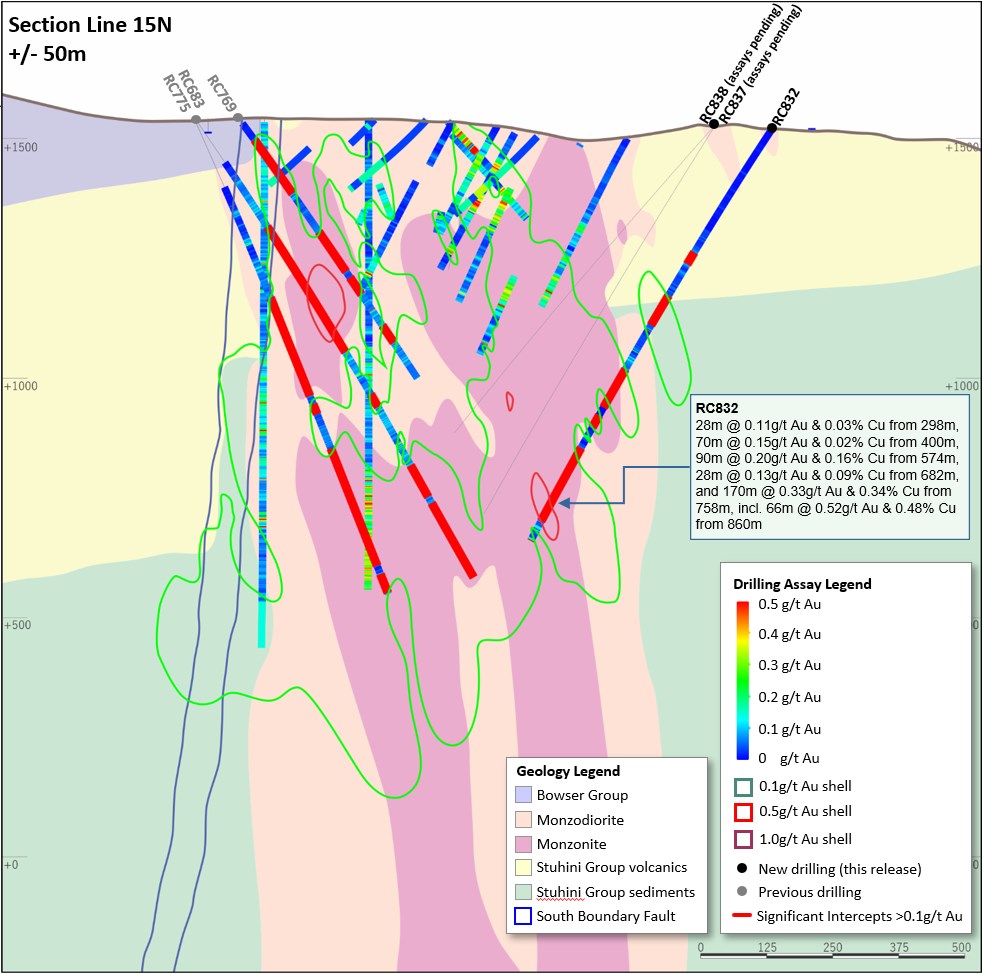
Figure 25. Schematic cross section of RC832 (Section Line 15N - as shown on Figure 23) showing Newcrest and Imperial drill holes and Newcrest intercepts (drill intercepts have been reported in Appendix 2 of this report, and in prior Newcrest exploration releases) 0.1 g/t Au, 0.5 g/t Au and 1 g/t Au shell projections generated from LeapfrogTM model. Due to window size (+/- 50m) and section orientation (150?) hole may appear on multiple sections.
To view an enhanced version of Figure 25, please visit:
https://images.newsfilecorp.com/files/7614/142076_c8c59e7494a96824_027full.jpg
Figure 26. Schematic cross section of RC813 and RC814 (Section Line 16N - as shown on Figure 23) showing Newcrest and Imperial drill holes and Newcrest intercepts (drill intercepts have been reported in Appendix 2 of this report, and in prior Newcrest exploration releases) 0.1 g/t Au, 0.5 g/t Au and 1 g/t Au shell projections generated from LeapfrogTM model. Due to window size (+/- 50m) and section orientation (150?) hole may appear on multiple sections.
To view an enhanced version of Figure 26, please visit:
https://images.newsfilecorp.com/files/7614/142076_c8c59e7494a96824_028full.jpg
Figure 27. Schematic cross section of RC822 and RC844 (Section Line 17N - as shown on Figure 23) showing Newcrest and Imperial drill holes and Newcrest intercepts (drill intercepts have been reported in Appendix 2 of this report, and in prior Newcrest exploration releases) 0.1 g/t Au, 0.5 g/t Au and 1 g/t Au shell projections generated from LeapfrogTM model. Due to window size (+/- 50m) and section orientation (150?) hole may appear on multiple sections.
To view an enhanced version of Figure 27, please visit:
https://images.newsfilecorp.com/files/7614/142076_c8c59e7494a96824_029full.jpg
Figure 28. Schematic cross section of RC834 (Section Line 32N - as shown on Figure 22) showing Newcrest and Imperial drill holes and Newcrest intercepts (drill intercepts have been reported in Appendix 2 of this report, and in prior Newcrest exploration releases) 0.1 g/t Au, 0.5 g/t Au and 1 g/t Au shell projections generated from LeapfrogTM model. Due to window size (+/- 50m) and section orientation (150?) hole may appear on multiple sections.
To view an enhanced version of Figure 28, please visit:
https://images.newsfilecorp.com/files/7614/142076_c8c59e7494a96824_030full.jpg
Figure 29. Schematic cross section of RC835 (Section Line 34N - as shown on Figure 22) showing Newcrest and Imperial drill holes and Newcrest intercepts (drill intercepts have been reported in Appendix 2 of this report, and in prior Newcrest exploration releases) 0.1 g/t Au, 0.5 g/t Au and 1 g/t Au shell projections generated from LeapfrogTM model. Due to window size (+/- 50m) and section orientation (150?) hole may appear on multiple sections.
To view an enhanced version of Figure 29, please visit:
https://images.newsfilecorp.com/files/7614/142076_c8c59e7494a96824_031full.jpg
Figure 30. Schematic cross section of RC818 and RC825 (Section Line 35N - as shown on Figure 22) showing Newcrest and Imperial drill holes and Newcrest intercepts (drill intercepts have been reported in Appendix 2 of this report, and in prior Newcrest exploration releases) 0.1 g/t Au, 0.5 g/t Au and 1 g/t Au shell projections generated from LeapfrogTM model. Due to window size (+/- 50m) and section orientation (150?) hole may appear on multiple sections.
To view an enhanced version of Figure 30, please visit:
https://images.newsfilecorp.com/files/7614/142076_c8c59e7494a96824_032full.jpg
Figure 31. Schematic cross section of RC820 (Section Line 36N - as shown on Figure 22) showing Newcrest and Imperial drill holes and Newcrest intercepts (drill intercepts have been reported in Appendix 2 of this report, and in prior Newcrest exploration releases) 0.1 g/t Au, 0.5 g/t Au and 1 g/t Au shell projections generated from LeapfrogTM model. Due to window size (+/- 50m) and section orientation (150?) hole may appear on multiple sections.
To view an enhanced version of Figure 31, please visit:
https://images.newsfilecorp.com/files/7614/142076_c8c59e7494a96824_033full.jpg
Figure 32. Schematic cross section of RC819 (Section Line 37N - as shown on Figure 22) showing Newcrest and Imperial drill holes and Newcrest intercepts (drill intercepts have been reported in Appendix 2 of this report, and in prior Newcrest exploration releases) 0.1 g/t Au, 0.5 g/t Au and 1 g/t Au shell projections generated from LeapfrogTM model. Due to window size (+/- 50m) and section orientation (150?) hole may appear on multiple sections.
To view an enhanced version of Figure 32, please visit:
https://images.newsfilecorp.com/files/7614/142076_c8c59e7494a96824_034full.jpg
Figure 33. Schematic cross section of RC808 and RC816R (Section Line 38N - as shown on Figure 22) showing Newcrest and Imperial drill holes and Newcrest intercepts (drill intercepts have been reported in Appendix 2 of this report, and in prior Newcrest exploration releases) 0.1 g/t Au, 0.5 g/t Au and 1 g/t Au shell projections generated from LeapfrogTM model. Due to window size (+/- 50m) and section orientation (150?) hole may appear on multiple sections.
To view an enhanced version of Figure 33, please visit:
https://images.newsfilecorp.com/files/7614/142076_c8c59e7494a96824_035full.jpg
Figure 34. Schematic cross section of RC807 and RC839 (Section Line 39N - as shown on Figure 22) showing Newcrest and Imperial drill holes and Newcrest intercepts (drill intercepts have been reported in Appendix 2 of this report, and in prior Newcrest exploration releases) 0.1g/t, 0.5g/t Au and 1g/t Au shell projections generated from LeapfrogTM model. Due to window size (+/- 50m) and section orientation (150?) hole may appear on multiple sections.
To view an enhanced version of Figure 34, please visit:
https://images.newsfilecorp.com/files/7614/142076_c8c59e7494a96824_036full.jpg
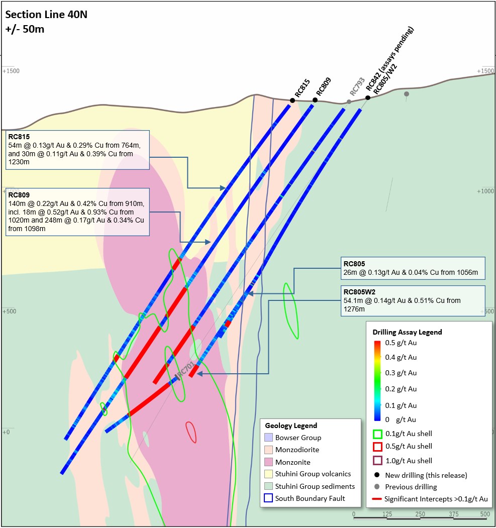
Figure 35. Schematic cross section of RC805/W2, RC809 and RC815 (Section Line 40N - as shown on Figure 22) showing Newcrest and Imperial drill holes and Newcrest intercepts (drill intercepts have been reported in Appendix 2 of this report, and in prior Newcrest exploration releases) 0.1g/t, 0.5g/t Au and 1g/t Au shell projections generated from LeapfrogTM model. Due to window size (+/- 50m) and section orientation (150?) hole may appear on multiple sections.
To view an enhanced version of Figure 35, please visit:
https://images.newsfilecorp.com/files/7614/142076_c8c59e7494a96824_037full.jpg
Figure 36. Schematic cross section of RC804/W (Section Line 41N - as shown on Figure 22) showing Newcrest and Imperial drill holes and Newcrest intercepts (drill intercepts have been reported in Appendix 2 of this report, and in prior Newcrest exploration releases) 0.1g/t, 0.5g/t Au and 1g/t Au shell projections generated from LeapfrogTM model. Due to window size (+/- 50m) and section orientation (150?) hole may appear on multiple sections.
To view an enhanced version of Figure 36, please visit:
https://images.newsfilecorp.com/files/7614/142076_c8c59e7494a96824_038full.jpg
Appendix 3
Havieron Project (Greatland Gold Plc - Joint Venture Agreement): JORC Table 1
Section 1: Sampling Techniques and Data
| Criteria |
| Commentary |
| Mineral tenement and land tenure status |
| The Havieron Project is entirely contained within mining tenement M45/1287, which is jointly owned by Greatland Pty Ltd and Newcrest Operations Limited. Newcrest has entered into a Joint Venture Agreement (effective 30 November 2020) and Farm-In Agreement (effective 12 March 2019) with Greatland Pty Ltd and Greatland Gold plc. Newcrest is the manager of the Havieron Project and holds a 70% interest (Greatland Gold holds a 30% interest). Newcrest and Jamukurnu-Yapalikurnu Aboriginal Corporation (formerly WDLAC) are parties to an ILUA which relates to the use of native title land for Newcrest's current operations at Telfer and its activities within a 60km radius around Telfer and includes its exploration activities at Havieron. The parties have agreed that the ILUA will apply to any future development activities by the Joint Venture Participants (Newcrest and Greatland Gold) at Havieron. The mining tenement M45/1287 wholly replaces the 12 sub-blocks of exploration tenement E45/4701 (former part of the exploration tenement on which the Havieron Project is based) and was granted on 10 September 2020. |
| Exploration done by other parties |
| Newcrest completed six core holes in the vicinity of the Havieron Project from 1991 to 2003. Greatland Gold completed drill targeting and drilling of nine Reverse Circulation (RC) drill holes with core tails for a total of approximately 6,800m in 2018. Results of drilling programs conducted by Greatland Gold have previously been reported on the Greatland Gold website. Drilling has defined an intrusion-related mineral system with evidence of breccia and massive sulphide-hosted higher-grade gold-copper mineralisation. |
| Geology |
| The Havieron Project is located within the north-western exposure of the Palaeo-Proterozoic to Neoproterozoic Paterson Orogen (formerly Paterson Province), 45 km east of Telfer. The Yeneena Supergroup hosts the Havieron prospect and consists of a 9km thick sequence of marine sedimentary rocks and is entirely overlain by approximately 420m of Phanerozoic sediments of the Paterson Formation and Quaternary aeolian sediments. Gold and copper mineralisation at Havieron consist of breccia, vein and massive sulphide replacement gold and copper mineralisation typical of intrusion-related and skarn styles of mineralisation. Mineralisation is hosted by metasedimentary rocks (meta-sandstones, meta-siltstones and meta-carbonate) and intrusive rocks of an undetermined age. The main mineral assemblage contains well developed pyrrhotite-chalcopyrite and pyrite sulphide mineral assemblages as breccia and vein infill, and massive sulphide lenses. The main mineralisation event is associated with amphibole-carbonate-biotite-sericite-chlorite wall rock alteration. Drilling has partially defined the extents of mineralisation which are observed over 650m by 350m within an arcuate shaped mineralised zone, and to depths of up to 1400m below surface. |
| Drill hole Information |
| As provided. |
| Data aggregation methods |
| Significant assay intercepts are reported as (A) length-weighted averages exceeding 1.0g/t Au greater than or equal to 10m, with a maximum of 5m consecutive internal dilution; and (B) length-weighted averages exceeding 0.2g/t Au for greater than or equal to 20m, with a maximum of 10m consecutive internal dilution, and (C) intervals of >30g/t which are greater or equal to 30 gram metres (Au_ppm x length). No top cuts are applied to intercept calculations. |
| Relationship between mineralisation widths and intercept lengths |
| Significant assay intervals reported represent apparent widths. Drilling is not always perpendicular to the dip of mineralisation and true widths are less than downhole widths. Estimates of true widths will only be possible when all results are received, and final geological interpretations have been completed. |
| Diagrams |
| As provided. |
| Balanced reporting |
| This is the twenty-fourth release of Exploration Results for this project made by Newcrest.. Exploration results have been reported by Newcrest since July 2019. Earlier reporting of exploration programs conducted by Newcrest and Greatland Gold have previously been reported. Exploration drilling programs are ongoing and further material results will be reported in subsequent Newcrest releases. |
| Other substantive exploration data |
| Nil |
| Further work |
| Growth drilling is targeting the extensions of the 30 June 2022 Indicated and Inferred Mineral Resource estimate and to define the limits of the Havieron mineralised system. |
Drillhole data(1)
Havieron Project, Paterson Province, Western Australia
Reporting Criteria: Intercepts reported are downhole drill width (not true width) Au >0.20ppm (0.2g/t Au) and minimum 20m downhole width with maximum consecutive internal dilution of 10m. Average grades are based on length-weighting of samples grades. Also highlighted are high grade intervals of Au >1.0ppm (1g/t Au) and minimum 10m downhole width with maximum consecutive internal dilution of 5m, and intervals of >30g/t which are greater or equal to 30 gram metres (Au_ppm x length) are tabled. Gold and copper grades are reported to two significant figures, the downhole lengths are rounded to 0.1m which may cause some apparent discrepancies in interval widths. Samples are from core drilling which is PQ, HQ or NQ in diameter. Core is photographed and logged by the geology team before being cut. Half core PQ, HQ and NQ samples are prepared for assay and the remaining material is retained in the core farm for future reference. Each assay batch is submitted with duplicates and standards to monitor laboratory quality. Total depth (end of hole) is rounded to one decimal place for reporting purposes. Collars denoted with a * show partial results, with further significant assays to be reported in subsequent exploration updates.
| Hole ID |
| Hole Type |
| Easting (m) |
| Northing (m) |
| RL (m) |
| Total Depth (m) |
| Azimuth |
| Dip |
| From (m) |
| To (m) |
| Interval (m) |
| Au (ppm) |
| Cu (pct) |
| Cut off |
| HAD055W10 |
| MR-DD |
| 463715 |
| 7597341 |
| 263 |
| 1248.1 |
| 47 |
| -56 |
| No Significant Results |
| HAD055W11 |
| MR-DD |
| 463715 |
| 7597341 |
| 263 |
| 1635.9 |
| 47 |
| -56 |
| No Significant Results |
| HAD086W5 |
| MR-DD |
| 464624 |
| 7598150 |
| 258 |
| 1685 |
| 225 |
| -65 |
| 1348.5 |
| 1383.3 |
| 34.8 |
| 0.34 |
| 0.06 |
| 0.2 g/t Au |
| HAD086W5 |
| MR-DD |
| 1401.1 |
| 1441 |
| 39.9 |
| 4.6 |
| 0.10 |
| 0.2 g/t Au |
| HAD086W5 |
| MR-DD |
| incl. |
| 1403 |
| 1423.6 |
| 20.6 |
| 8.7 |
| 0.13 |
| 1.0 g/t Au |
| HAD086W5 |
| MR-DD |
| 1491.8 |
| 1533.7 |
| 41.9 |
| 1.7 |
| 0.11 |
| 0.2 g/t Au |
| HAD086W5 |
| MR-DD |
| incl. |
| 1512 |
| 1528.1 |
| 16.1 |
| 3.9 |
| 0.12 |
| 1.0 g/t Au |
| HAD086W6 |
| MR-DD |
| 464624 |
| 7598150 |
| 258 |
| 1524.4 |
| 225 |
| -65 |
| 1337 |
| 1447 |
| 110 |
| 1.7 |
| 0.16 |
| 0.2 g/t Au |
| HAD086W6 |
| MR-DD |
| incl. |
| 1356.1 |
| 1369 |
| 12.9 |
| 3.5 |
| 0.49 |
| 1.0 g/t Au |
| HAD086W6 |
| MR-DD |
| incl. |
| 1380.3 |
| 1401 |
| 20.7 |
| 4.4 |
| 0.10 |
| 1.0 g/t Au |
| HAD086W6 |
| MR-DD |
| incl. |
| 1357 |
| 1358 |
| 1.0 |
| 33 |
| 0.00 |
| 30 g.m. Au |
| HAD098W2 |
| MR-DD |
| 463591 |
| 7597381 |
| 264 |
| 1748.4 |
| 38 |
| -61 |
| 1170 |
| 1197 |
| 27 |
| 1.9 |
| 0.19 |
| 0.2 g/t Au |
| HAD098W2 |
| MR-DD |
| incl. |
| 1178 |
| 1190 |
| 12 |
| 3.7 |
| 0.26 |
| 1.0 g/t Au |
| HAD098W2 |
| MR-DD |
| 1335.7 |
| 1375 |
| 39.3 |
| 2.1 |
| 0.12 |
| 0.2 g/t Au |
| HAD098W2 |
| MR-DD |
| incl. |
| 1374.2 |
| 1375 |
| 0.8 |
| 65 |
| 0.13 |
| 30 g.m. Au |
| HAD098W2 |
| MR-DD |
| 1387.3 |
| 1408 |
| 20.7 |
| 3.6 |
| 0.43 |
| 1.0 g/t Au |
| HAD098W2 |
| MR-DD |
| incl. |
| 1392.4 |
| 1392.7 |
| 0.3 |
| 154 |
| 0.01 |
| 30 g.m. Au |
| HAD098W2 |
| MR-DD |
| 1604.6 |
| 1632 |
| 27.4 |
| 0.75 |
| 0.04 |
| 0.2 g/t Au |
| HAD098W3 |
| MR-DD |
| 463591 |
| 7597381 |
| 264 |
| 1908.2 |
| 38 |
| -61 |
| 1379.6 |
| 1395 |
| 15.4 |
| 12 |
| 0.27 |
| 1.0 g/t Au |
| HAD098W3 |
| MR-DD |
| incl. |
| 1381.2 |
| 1381.4 |
| 0.2 |
| 175 |
| 1.2 |
| 30 g.m. Au |
| HAD098W3 |
| MR-DD |
| incl. |
| 1391.6 |
| 1393 |
| 1.4 |
| 47 |
| 0.34 |
| 30 g.m. Au |
| HAD098W3 |
| MR-DD |
| 1759 |
| 1800 |
| 41 |
| 0.30 |
| 0.01 |
| 0.2 g/t Au |
| HAD098W4 |
| MR-DD |
| 463591 |
| 7597381 |
| 264 |
| 1098.7 |
| 38 |
| -61 |
| No Significant Results |
| HAD098W5 |
| MR-DD |
| 463591 |
| 7597381 |
| 264 |
| 1849.1 |
| 38 |
| -61 |
| 1114.7 |
| 1220.9 |
| 106.2 |
| 0.78 |
| 0.12 |
| 0.2 g/t Au |
| HAD098W5 |
| MR-DD |
| incl. |
| 1196.4 |
| 1208.7 |
| 12.3 |
| 1.6 |
| 0.27 |
| 1.0 g/t Au |
| HAD098W5 |
| MR-DD |
| 1357.2 |
| 1438.5 |
| 81.3 |
| 3.2 |
| 0.29 |
| 0.2 g/t Au |
| HAD098W5 |
| MR-DD |
| incl. |
| 1360.5 |
| 1413.8 |
| 53.3 |
| 3.5 |
| 0.3 |
| 1.0 g/t Au |
| HAD098W5 |
| MR-DD |
| incl. |
| 1421 |
| 1438.5 |
| 17.5 |
| 3.9 |
| 0.26 |
| 1.0 g/t Au |
| HAD098W5 |
| MR-DD |
| 1548 |
| 1574.5 |
| 26.5 |
| 1.1 |
| 0.06 |
| 0.2 g/t Au |
| HAD098W6 |
| MR-DD |
| 463591 |
| 7597381 |
| 264 |
| 1203 |
| 38 |
| -61 |
| Assays Pending |
| HAD098W7 |
| MR-DD |
| 463591 |
| 7597381 |
| 264 |
| 1836.8 |
| 38 |
| -61 |
| Assays Pending |
| HAD104W3 |
| MR-DD |
| 463522 |
| 7597782 |
| 257 |
| 1965 |
| 87 |
| -63 |
| 1414.5 |
| 1463.3 |
| 48.8 |
| 0.7 |
| 0.18 |
| 0.2 g/t Au |
| HAD104W3 |
| MR-DD |
| 1566 |
| 1628 |
| 62 |
| 3.0 |
| 0.12 |
| 0.2 g/t Au |
| HAD104W3 |
| MR-DD |
| incl. |
| 1593 |
| 1619.7 |
| 26.7 |
| 6.4 |
| 0.16 |
| 1.0 g/t Au |
| HAD104W3 |
| MR-DD |
| 1640 |
| 1667.7 |
| 27.7 |
| 1.5 |
| 0.24 |
| 0.2 g/t Au |
| HAD145AW3 |
| MR-DD |
| 463201 |
| 7597816 |
| 256 |
| 1560.6 |
| 74 |
| -65 |
| 1285.9 |
| 1317.2 |
| 31.3 |
| 1.2 |
| 0.68 |
| 0.2 g/t Au |
| HAD145AW3 |
| MR-DD |
| 1433 |
| 1476 |
| 43 |
| 0.33 |
| 0.05 |
| 0.2 g/t Au |
| HAD145AW5 |
| MR-DD |
| 463201 |
| 7597816 |
| 256 |
| 2162.2 |
| 74 |
| -65 |
| 1509 |
| 1564 |
| 55 |
| 0.28 |
| 0.12 |
| 0.2 g/t Au |
| HAD145AW5 |
| MR-DD |
| 1623 |
| 1791 |
| 168 |
| 0.69 |
| 0.27 |
| 0.2 g/t Au |
| HAD145AW5 |
| MR-DD |
| incl. |
| 1686 |
| 1697.3 |
| 11.3 |
| 2.4 |
| 0.53 |
| 1.0 g/t Au |
| HAD145AW5 |
| MR-DD |
| 1983.5 |
| 2004 |
| 20.5 |
| 0.45 |
| 0.01 |
| 0.2 g/t Au |
| HAD145AW5 |
| MR-DD |
| 2038 |
| 2076 |
| 38 |
| 1.9 |
| 0.17 |
| 0.2 g/t Au |
| HAD145AW5 |
| MR-DD |
| incl. |
| 2053 |
| 2076 |
| 23 |
| 2.5 |
| 0.16 |
| 1.0 g/t Au |
| HAD152W2 |
| MR-DD |
| 463401 |
| 7597059 |
| 254 |
| 1898 |
| 33 |
| -64 |
| 1453 |
| 1473 |
| 20 |
| 7.6 |
| 0.14 |
| 0.2 g/t Au |
| HAD152W2 |
| MR-DD |
| incl. |
| 1455 |
| 1471 |
| 16 |
| 9.4 |
| 0.17 |
| 1.0 g/t Au |
| HAD152W2 |
| MR-DD |
| incl. |
| 1469 |
| 1469.9 |
| 0.9 |
| 66 |
| 0.72 |
| 30 g.m. Au |
| HAD152W2 |
| MR-DD |
| 1724 |
| 1844 |
| 120 |
| 2.1 |
| 0.17 |
| 0.2 g/t Au |
| HAD152W2 |
| MR-DD |
| incl. |
| 1730 |
| 1732 |
| 2.0 |
| 43 |
| 0.01 |
| 30 g.m. Au |
| HAD152W2 |
| MR-DD |
| incl. |
| 1781.7 |
| 1802 |
| 20.3 |
| 3.1 |
| 0.68 |
| 1.0 g/t Au |
| HAD152W3 |
| MR-DD |
| 463401 |
| 7597059 |
| 254 |
| 2141.6 |
| 33 |
| -64 |
| 1695 |
| 1777 |
| 82 |
| 2.7 |
| 0.21 |
| 0.2 g/t Au |
| HAD152W3 |
| MR-DD |
| incl. |
| 1718 |
| 1719.1 |
| 1.1 |
| 116 |
| 1.4 |
| 30 g.m. Au |
| HAD152W3 |
| MR-DD |
| 1798 |
| 1862.5 |
| 64.5 |
| 2.8 |
| 1.1 |
| 0.2 g/t Au |
| HAD152W3 |
| MR-DD |
| incl. |
| 1843.5 |
| 1857 |
| 13.5 |
| 9.8 |
| 0.89 |
| 1.0 g/t Au |
| HAD152W3 |
| MR-DD |
| incl. |
| 1848 |
| 1849.7 |
| 1.7 |
| 51 |
| 0.72 |
| 30 g.m. Au |
| HAD152W3 |
| MR-DD |
| 1984 |
| 2032 |
| 48 |
| 0.88 |
| 0.03 |
| 0.2 g/t Au |
| HAD152W3 |
| MR-DD |
| 2054 |
| 2130.2 |
| 76.2 |
| 1.1 |
| 0.08 |
| 0.2 g/t Au |
| HAD152W4 |
| MR-DD |
| 463401 |
| 7597059 |
| 254 |
| 2169.5 |
| 33 |
| -64 |
| Assays Pending |
| HAD152W5 |
| MR-DD |
| 463401 |
| 7597059 |
| 254 |
| 2172.2 |
| 33 |
| -64 |
| Assays Pending |
| HAD153W1 |
| MR-DD |
| 464786 |
| 7598418 |
| 269 |
| 1690.5 |
| 200 |
| -61 |
| 1557 |
| 1611 |
| 54 |
| 0.48 |
| 0.36 |
| 0.2 g/t Au |
| HAD153W1 |
| MR-DD |
| 1641 |
| 1673 |
| 32 |
| 0.72 |
| 0.04 |
| 0.2 g/t Au |
| HAD153W2 |
| MR-DD |
| 464786 |
| 7598418 |
| 269 |
| 1756.1 |
| 200 |
| -61 |
| 1663.5 |
| 1685 |
| 21.5 |
| 3.0 |
| 0.22 |
| 0.2 g/t Au |
| HAD156 |
| MR-DD |
| 463672 |
| 7596940 |
| 255 |
| 2323.3 |
| 30 |
| -75 |
| 2079 |
| 2109 |
| 30 |
| 1.5 |
| 0.18 |
| 0.2 g/t Au |
| HAD157 |
| MR-DD |
| 464558 |
| 7599017 |
| 258 |
| 933.8 |
| 270 |
| -65 |
| No Significant Results |
| HAD158 |
| MR-DD |
| 464062 |
| 7599516 |
| 260 |
| 1174.6 |
| 90 |
| -65 |
| No Significant Results |
| HAD159 |
| MR-DD |
| 464086 |
| 7597253 |
| 261 |
| 1917.7 |
| 29 |
| -76 |
| 1320 |
| 1360 |
| 40 |
| 0.67 |
| 0.06 |
| 0.2 g/t Au |
| HAD159 |
| MR-DD |
| 1388 |
| 1416 |
| 28 |
| 0.33 |
| 0.05 |
| 0.2 g/t Au |
| HAD159 |
| MR-DD |
| 1498 |
| 1536 |
| 38 |
| 0.75 |
| 0.18 |
| 0.2 g/t Au |
| HAD159 |
| MR-DD |
| 1694 |
| 1754 |
| 60 |
| 0.6 |
| 0.15 |
| 0.2 g/t Au |
| HAD159 |
| MR-DD |
| 1766 |
| 1808 |
| 42 |
| 0.63 |
| 0.04 |
| 0.2 g/t Au |
| HAD160 |
| MR-DD |
| 463660 |
| 7596898 |
| 255 |
| 1083.4 |
| 90 |
| -63 |
| No Significant Results |
| HAD163 |
| MR-DD |
| 464491 |
| 7598143 |
| 258 |
| 1725 |
| 198 |
| -80 |
| Assays Pending |
| HAD165 |
| MR-DD |
| 464067 |
| 7599163 |
| 257 |
| 967 |
| 85 |
| -65 |
| Assays Pending |
| MEC001 |
| MR-DD |
| 463150 |
| 7595777 |
| 253 |
| 497.9 |
| 45 |
| -73 |
| Assays Pending |
| MEC001W1 |
| MR-DD |
| 463150 |
| 7595777 |
| 253 |
| 1143.2 |
| 45 |
| -73 |
| Assays Pending |
| NOR002 |
| MR-DD |
| 464229 |
| 7600143 |
| 258 |
| 1177.5 |
| 85 |
| -75 |
| Assays Pending |
# drilling in progress, **partial intercept, assays pending. ^updated intercept ^^previously reported intercept, +intercept within published resource
Figure 37. Schematic plan view map showing drill hole locations and significant intercepts reported in this release superimposed on the interpreted geology. Previously reported holes are not shown for the sake of clarity. Note some holes and results appear on multiple sections due to the sections orientation and sections overlap.
To view an enhanced version of Figure 37, please visit:
https://images.newsfilecorp.com/files/7614/142076_c8c59e7494a96824_039full.jpg
Figure 38. Schematic cross section of geology and significant new drillhole intercepts (looking northwest, Section Line S1, +/-50m section width, as shown in Figure 37). Due to section window size and orientation holes may appear on multiple sections. This diagram highlights >50gram metres intersections drilled during the period. Reported drill holes are outside of the existing resource.
To view an enhanced version of Figure 38, please visit:
https://images.newsfilecorp.com/files/7614/142076_c8c59e7494a96824_040full.jpg
Figure 39. Schematic cross section of geology and significant new drillhole intercepts (looking northwest, Section Line S2, +/-50m section width, as shown in Figure 37). Due to section window size and orientation holes may appear on multiple sections. This diagram highlights >50gram metres intersections drilled during the period. Reported drill holes are outside of the existing resource.
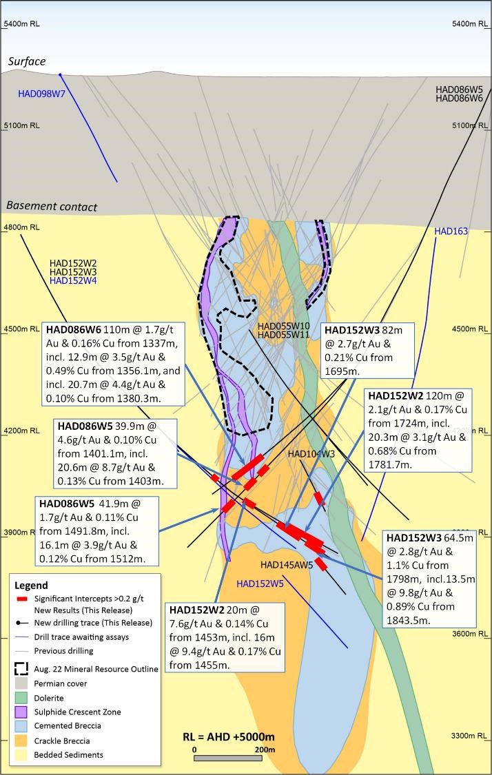
To view an enhanced version of Figure 39, please visit:
https://images.newsfilecorp.com/files/7614/142076_c8c59e7494a96824_041full.jpg
Figure 40. Schematic cross section of geology and significant new drillhole intercepts (looking northwest, Section Line S3, +/-50m section width, as shown in Figure 37). The blue intercepts represent results wholly or partially within the Mineral Resource. Due to section window size and orientation holes may appear on multiple sections. This diagram highlights >50gram metres intersections drilled during the period which. Reported drill holes are outside of the existing resource.
To view an enhanced version of Figure 40, please visit:
https://images.newsfilecorp.com/files/7614/142076_c8c59e7494a96824_042full.jpg
Figure 41. Schematic cross section of geology and significant new drillhole intercepts (looking northwest, Section Line S4, +/-100m section width, as shown in Figure 37). Due to section window size and orientation holes may appear on multiple sections. This diagram highlights >50gram metres intersections drilled during the quarter. Reported drill holes are outside of the existing resource.
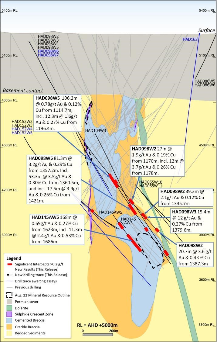
To view an enhanced version of Figure 41, please visit:
https://images.newsfilecorp.com/files/7614/142076_c8c59e7494a96824_043full.jpg
Forward Looking Statements
This document includes forward looking statements and forward looking information within the meaning of securities laws of applicable jurisdictions. Forward looking statements can generally be identified by the use of words such as "may", "will", "expect", "intend", "plan", "estimate", "target", "anticipate", "believe", "continue", "objectives", "outlook" and "guidance", or other similar words and may include, without limitation, statements regarding estimated reserves and resources, internal rates of return, expansion, exploration and development activities and the specifications, targets, results, analyses, interpretations, benefits, costs and timing of them; certain plans, strategies, aspirations and objectives of management, anticipated production, sustainability initiatives, climate scenarios, dates for projects, reports, studies or construction, expected costs, cash flow or production outputs and anticipated productive lives of projects and mines. The Company continues to distinguish between outlook and guidance. Guidance statements relate to the current financial year. Outlook statements relate to years subsequent to the current financial year.
These forward looking statements involve known and unknown risks, uncertainties and other factors that may cause the Company's actual results, performance, and achievements to differ materially from any future results, performance or achievements, or industry results, expressed or implied by these forward looking statements. Relevant factors may include, but are not limited to, changes in commodity prices, foreign exchange fluctuations and general economic conditions, increased costs and demand for production inputs, the speculative nature of exploration and project development, including the risks of obtaining necessary licences and permits and diminishing quantities or grades of resources or reserves, political and social risks, changes to the regulatory framework within which the Company operates or may in the future operate, environmental conditions including extreme weather conditions, recruitment and retention of personnel, industrial relations issues and litigation. For further information as to the risks which may impact on the Company's results and performance, please see the risk factors discussed in the Operating and Financial Review included in the Appendix 4E and Financial Report for the year ended 30 June 2022 and the Annual Information Form dated 6 December 2021 which are available to view at www.asx.com.au under the code "NCM" and on Newcrest's SEDAR profile.
Forward looking statements are based on management's current expectations and reflect Newcrest's good faith assumptions, judgements, estimates and other information available as at the date of this report and/or the date of Newcrest's planning or scenario analysis processes as to the financial, market, regulatory and other relevant environments that will exist and affect Newcrest's business and operations in the future. Newcrest does not give any assurance that the assumptions will prove to be correct. There may be other factors that could cause actual results or events not to be as anticipated, and many events are beyond the reasonable control of Newcrest. Readers are cautioned not to place undue reliance on forward looking statements, particularly in the current economic climate with the significant volatility, uncertainty and disruption caused by global events such as geopolitical tensions and the ongoing COVID19 pandemic. Forward looking statements in this document speak only at the date of issue. Except as required by applicable laws or regulations, Newcrest does not undertake any obligation to publicly update or revise any of the forward looking statements or to advise of any change in assumptions on which any such statement is based.
Ore Reserves and Mineral Resources Reporting Requirements
As an Australian Company with securities listed on the Australian Securities Exchange (ASX), Newcrest is subject to Australian disclosure requirements and standards, including the requirements of the Corporations Act 2001 and the ASX. Investors should note that it is a requirement of the ASX Listing Rules that the reporting of Ore Reserves and Mineral Resources in Australia is in accordance with the 2012 Edition of the Australasian Code for Reporting of Exploration Results, Mineral Resources and Ore Reserves (the JORC Code) and that Newcrest's Ore Reserve and Mineral Resource estimates and reporting comply with the JORC Code.
Newcrest is also subject to certain Canadian disclosure requirements and standards, as a result of its secondary listing on the Toronto Stock Exchange (TSX), including the requirements of National Instrument 43-101 - Standards of Disclosure for Mineral Projects (NI 43-101). Investors should note that it is a requirement of Canadian securities law that the reporting of Mineral Reserves and Mineral Resources in Canada and the disclosure of scientific and technical information concerning a mineral project on a property material to Newcrest comply with NI 43-101.
Newcrest's material properties are currently Cadia, Lihir, Red Chris and Wafi-Golpu. Copies of the NI 43-101 Reports for Cadia, Lihir and Wafi-Golpu, which were released on 14 October 2020, and Red Chris, which was released on 30 November 2021, are available at www.newcrest.com and on Newcrest's SEDAR profile.
Competent Person's Statement
The information in this document that relates to Exploration Targets, Exploration Results, and related scientific and technical information, is based on and fairly represents information compiled by Mr F. MacCorquodale. Mr MacCorquodale is the General Manager - Greenfields Exploration and a full-time employee of Newcrest Mining Limited. He is a shareholder in Newcrest Mining Limited and is entitled to participate in Newcrest's executive equity long term incentive plan, details of which are included in Newcrest's 2022 Remuneration Report. He is a Member of the Australian Institute of Geoscientists. Mr MacCorquodale has sufficient experience which is relevant to the styles of mineralisation and types of deposits under consideration and to the activity which he is undertaking to qualify as a Competent Person as defined in the JORC Code and as a Qualified Person under
NI 43-101. Mr MacCorquodale approves the disclosure of scientific and technical information contained in this document and consents to the inclusion of material of the matters based on his information in the form and context in which it appears.
Authorised by the Newcrest Disclosure Committee
For further information please contact
Investor Enquires
Tom Dixon
+61 3 9522 5570
+61 450 541 389
Tom.Dixon@newcrest.com.au
Rebecca Lay
+61 3 9522 5298
+61 438 355 511
Rebecca.Lay@newcrest.com.au
North American Investor Enquiries
Vlada Cvijetinovic
+1 604 566 8781
+1 604 240 2998
Vlada.Cvijetinovic@newcrest.com.au
Media Enquiries
Tim Salathiel
+61 3 9522 4263
+61 407 885 272
Tim.Salathiel@newcrest.com.au
This information is available on our website at www.newcrest.com
1 # drilling in progress ** partial intercept, assays pending ^ updated intercept or ^^ previously reported.
2 # drilling in progress ** partial intercept, assays pending ^ updated intercept or ^^ previously reported.
3 # drilling in progress ** partial intercept, assays pending ^ updated intercept or ^^ previously reported.
To view the source version of this press release, please visit https://www.newsfilecorp.com/release/142076