NOB:CC - Noble Mineral Exploration Inc.: Exploration Update
(TheNewswire)
Toronto, Ontario - TheNewswire - May 2, 2022 - Noble Mineral ExplorationInc. ( “Noble” or the “Company” ) (TSXV:NOB ) ( FRANKFURT:NB7 ) ( OTC:NLPXF) is pleased to report on the proposed programs fora number of its active projects.
Dargavel Township Gold Trend, Ontario(4,300 ha)
In January of 2022, the Company drilled 1253 meters inseven holes on its 50% interest in Dargavel Twp in Project 81. Thisdrill program qualified for a $200,000 OJEP grant from the OntarioGovernment. 291 Samples were submitted to ActLabs in Timmins for assayand due to backlogs at the lab, Noble has been advised that resultsshould be forthcoming within the next two weeks. Upon receipt of theresults Noble will determine how to proceed in what would likely be awinter follow up drill program.
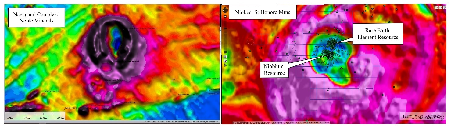
Nagagami Carbonatite Niobium and RareEarths Project, Ontario (14,000 ha)
Consultations have been initiated with the ConstanceLake First Nation (CLFN) and it is anticipated that Noble and CLFNwill enter into an Exploration Agreement in the coming days upon theexecution of which a helicopter supported minimum 1500-meter drillprogram is proposed for which Noble has recently received an EarlyExploration Permit from the Province.
Past work in the Nagagamiarea has beenspotty in the past. Part of this isdue to the fact that thecomplex is not exposed on surface. Algoma OreProperties performed the original airborne magnetic survey in the areathat identified the complex. Limited drillingwas aimed at the magneticring structure in search of iron deposits. Despite drilling in the wrong geology for niobium and rareearth metals, one of the Algoma drillholes returned 0.3% Nb205 from agrab sample of syenite taken at 230 feet downhole. Fluorite was noted in one drill hole as red-brown, waxy hydronephelite(an alteration form of nepheline) comprising 5-10% of therock. The existence of fluorite ischaracteristic of carbonatite style mineralization.
Figure 1: Comparison of the NagagamiComplex (left) with the Niobec Mine in Quebec
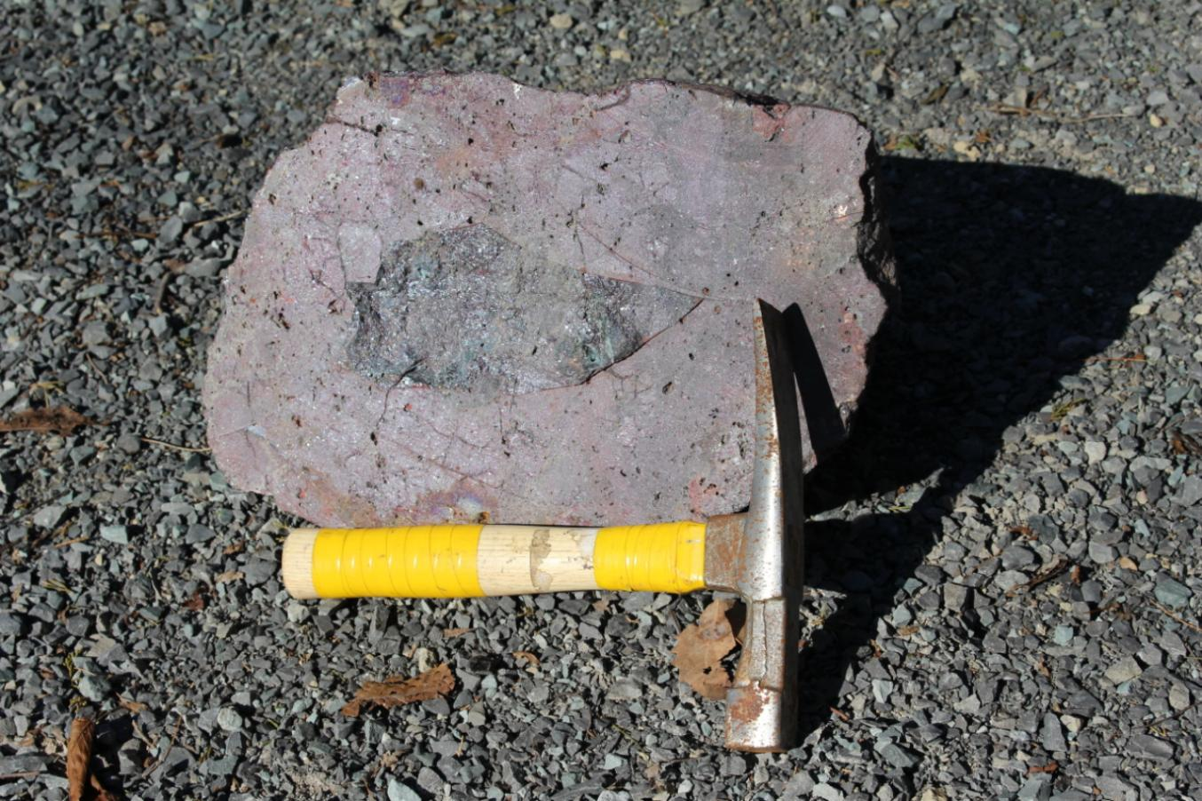
The Cousineau Boulder Project (4,500ha)
In 2019 Ontario Geological Survey analyzed a samplefrom the 140kg boulder and determined that the boulder contained:71.8% copper; 3.5% lead, 1.09% zinc; 252 g/T of silver, 3.79 g/T ofgold; 4.43 g/T of palladium; and 2.22 g/T of platinum and consistedprimarily of the mineral cuprite
During the Fall of 2021 Noble launched an exploration program on the property to in an effort toidentify the source of the boulder. Basal till samples collected fromtwo fence lines of hand auger holes, located about 100 m and 1 kmnorth of the boulder location, produced 35 gold grains. These goldgrains defined a southeast-northwest trending dispersion train thatindicates they were transported southeast by a glacial transport froma source area located to the northwest. The dispersion train appearsto begin near a northeast trending magnetic anomaly to the northwestof the property. The gold grains are predominantly reshaped (24) butalso include modified (7) and pristine (4), supporting evidence oflocal source. The cost of the staking, sampling and assaying to datehas been applied against the option costs.
Work will continue during the 2022 field seasonincluding a helicopter airborne survey, glacial till investigationsand diamond drilling.
Figure 2: The Cousineau Boulder cutin half.
Buckingham Graphite Project, Quebec(3,700 ha)
A trenching program was initiated by a third party in2014 based on airborne survey results and limited groundgeophysics. Trenching verified thatgraphite mineralization was causing the detectedelectromagnetic anomaly. All samples returnedgraphite mineralized intersections with a best result of 8.2% Cg over4.75* meters, including 12.1% Cg over 1* meter and 12.5% Cg over 3.5*meters. Another trench was excavated about 75mNE of the first trench where one section yielded 21.6% Cg over 14.5*meters and 16.8% Cg over 3.9* meters. (*True widths not known at thistime)
In 2015, a 20-kilogram bulk sample was taken fromTrench 22C and subjected to initial flotation testing for graphite.The bulk sample was submitted to a simple flotation test, withoutprocess optimization or chemical treatment, such as addition of acidleach or alkaline roast. The head grade obtainedwas 20.7% Cg and returned an overall combined flotation concentratepurity of 94.8%. The results of the testingindicated 32% of the flakes were large (+65 mesh) to jumbo (+28 mesh)in size and the purity obtained in these large fractions ranged from94.8 to 96.1%.
The 2022 field work will be a two-phase program toinclude:
Phase 1
-
Re-processing of airborne data from the 2013 survey
-
Property visit to locate trenches, grab samples and drill hole collars
-
Beep Mat survey to locate new graphite mineralization
Phase 2
-
2,000 meters of diamond drilling
Island Pond Property CentralNewfoundland (14,400 ha)
The property, known as Island Pond, is located withinan area of Central Newfoundland that is geologically mapped as asingle unit of Cambrian-Ordovician siliclastic sediments trappedbetween a series of non-magnetic Devonian Plutons to the west andsoutheast. The plutons themselves are not considered to be ofexploration interest but they could have altered the rocks aroundthem. From the regional magnetic data, a strong magnetic trend existswithin the siliclastics that is interpreted to be an unmapped volcanicintrusion. A preliminary structural interpretation, based solely onregional scale aeromagnetic surveys, suggests a multi-fold metamorphichistory with a very high potential for repetition of stratigraphywithin these newly staked claims. Spruce Ridge Resources (SHL)Foggy Pond Property, contiguous to the east, shows a similar magneticfeature. SHL has reported their preliminary interpretation indicatingthe possibility for a repetition of known copper and goldmineralization on a western limb. Preliminary interpretation ofrecently acquired high resolution magnetic data over Foggy Pond showlocalized magnetic anomalies that could be ophiolite slivers along amajor northeast trending structure analogous to the Grub Line locatedjust east of New Found Gold’s high-grade gold discovery locatedapproximately 75 km to the east.
Historic exploration on the Spruce Ridge Great Burntand South Pond Property was found to contain economic concentrationsof copper and possibly gold within volcanic rocks that intruded thesiliclastic sediments. The magnetic trend at Island Pond is over 22 kmin strike length and up to 3.5 km wide. This region of Newfoundlandhas received almost no exploration due to the thin but extensiveoverburden cover and lack of forest suitable for the logging industry(which would have resulted in a road infrastructure). Island Pond iscontiguous to Spruce Ridge’s recently staked Foggy Pond Property(see Spruce Ridge press release Dec-22-2021) and is located 14 kmnorthwest of Spruce Ridge’s South Pond gold-copper discovery and 56km southeast of the historic Buchans high-grade zinc mine.
An airborne geophysical survey is scheduled for earlysummer.
Cere Villebon, Quebec (483 ha)
Drilling and resource estimates done by the Groupe LaFosse Platinum Inc., in 1987, evaluated a historical resource of 421,840 tonnes grading 0.52%copper, 0.72 % nickel and 1.08 g/t combined platinum-palladium (Groupe La Fosse Platinum Inc., 1987 Annual Report). This estimate is historical in nature, non-compliant to NI 43-101 Mineral Resources and MineralReserves standards, and therefore should not be relied upon. AQualified Person has not done sufficient work to classify thehistorical estimate as current mineral resources, and these estimatesshould only be considered as an indication of the mineral potential ofthe Property.
Diamond Drill Hole FV-87-1 drilled by LaFosse Platinumin 1987 into the North Zone intersected 27.38* meters of 0.70% nickel, 0.68%copper, 0.23 g/t platinum, 0.64 g/t palladium and 0.08 g/t goldincluding 7.65* meters of 0.94% nickel, 1.02% copper .
* Exact width not known at this time.
Future work will include a complete compilation of pastdrilling and a site visit to surface sample the zone and explore foradditional mineralization.
Laverlochere, Quebec (518 ha)
The Laverlochere property is located on the southernpart, of the east-west trending Belleterre-Angliers greenstone belt that is made up of an assemblage ofsedimentary and volcanic rocks of Archaen age. Several Nickel-Copper-Platinum Group deposits and showingshave been discovered in the Belleterre-Angliers greenstone belt.Approximately 30 km east of the Laverlochere property, the Kelly Lakeproperty reportedly contains a deposit of 1.4 million tonnes of 0.7%Cu, 0.7 Ni, 1/3 g/t Pt+Pd and a potential for minor amounts of Cobaltand Rhenium and in the same general area, Blondeau Nickel has outlined a 227,000t deposit. Grading 0.45% Cuand 0.45% Ni. Historic exploration in the areahas outlined four separate zones of Nickel- Copper-Platinum Groupmineralization in gabbroic bodies interbedded in mafic to felsicvolcanics (these reserves are 43-101 non-compliant and historic innature).
On the Laverlochere property, historic trenching and drilling on the north shore of Lac Rousselot led to the discoveryof a band of iron formation, striking N60°E. The iron formation is brecciated and contains pyrite-richlenses and veinlets of quartz. A trench, approximately 1,080 m to the southeast of the iron formation, exposed a silica bearing that contains considerable veinlets or dike-like masses of quartz thatare well mineralized with chalcopyrite andpyrite. A 1.8 by 3.0 m shaft was sunk on a 3 mlong by 30 cm wide, mineralized quartz lense. The lense strikesnorthwest and cuts across N30°W striking sheared andesites. The mineralization is primarily chalcopyrite and a 30 cm sample across the quartz lenseanalyzed 0.57% copper and 2.6g/t gold .
In 1969, Inco drilled three holes under Lac Rousselot. Drillhole 32375 was drilled to a depthof 309 m and in the upper section (0 to 93.9 m) intersected mainlyandesitic and gabbroic rocks that were locally, weakly mineralized inpyrite, pyrrhotite and chalcopyrite. The lower part of the hole (from93.9 to 309 m) intersected serpentinizedperidotite that was systematically analyzed for copper, nickel andcobalt. The analyses reportedly revealed a 214.7-meter mineralized interval grading0.01% Copper, 0.29% Nickel and 0.02% Cobalt (Exact width not known at this time).
Drill hole 32376, intersected mainly intermediatevolcanics, gabbroic, and dioritic rocks down to 97.6 m that wereweakly mineralized with pyrite, chalcopyrite and pyrrhotite. From 97.6 m to the bottom of the hole at 108.8 mperidotite was intersected. Eight samples of core from the gabbro,andesite and a chlorite bearing schist were analyzed for copper,nickel and zinc. Three were also analyzed for platinum and palladiumand gave the following results for palladium of 0.12 g/t, 0.28 g/t and 0.31 g/t and forplatinum 0.16 g/t, 0.37 g/t and 0.12 g/t . Theperidotite graded 0.02% Cu and0.224% Ni over the 11.2-meter interval (Exactwidth not known at this time).
Future work will include a complete compilation of pastwork and a property visit to identify historicaland new mineralization on the property.
Calder-Lennox Twp Ontario (4,800ha)
Noble will carry out a 2-3 drill hole program to testan untested geophysical target on its Calder Twp option. This drillprogram is scheduled for late summer 2022.
All exploration results disclosed in this news releaseare historical and are therefore non-compliant with the requirementsof National Instrument43-101.
Michael Newbury PEng (ON), a “qualified person” assuch term is defined by National Instrument 43-101, has reviewed thedata disclosed in this news release, and has otherwise reviewed andapproved the technical information in this news release on behalf ofNoble.
About Noble Mineral ExplorationInc.:
Noble Mineral Exploration Inc. is a Canadian-basedjunior exploration company which, in addition to its shareholdings inCanada Nickel Company Inc., Spruce Ridge Resources Ltd. and MacDonaldMines Exploration Ltd., and its interest in the Holdsworth goldexploration property in the area of Wawa, Ontario, will continue tohold ~25,000 hectares of mineral rights in the Timmins-Cochrane areasof Northern Ontario known as Project 81, as well as an additional~11,000 hectares in the Timmins area and ~14,400 hectares of miningclaims in Central Newfoundland. Project 81 hosts diversifieddrill-ready gold, nickel-cobalt and base metal exploration targets atvarious stages of exploration. It will also hold its recently acquired~14,600 hectares in the Nagagami Carbonatite Complex near Hearst,Ontario, as well as ~3,700 hectares in the Buckingham GraphiteProperty, ~518 hectares in the Laverlochere Nickel, Copper, PGNMproperty and ~482 hectares in the Cere-Villebon Nickel, Copper, PGMproperty, all of which are in the province of Quebec. More detailedinformation is available on the website at www.noblemineralexploration.com .
Noble’s common shares trade on the TSX VentureExchange under the symbol “NOB.”
Neither TSX Venture Exchange nor itsRegulation Services Provider (as that term is defined in the policiesof the TSX Venture Exchange) accepts responsibility for the adequacyor accuracy of this release. No stock exchange,securities commission or other regulatory authority has approved ordisapproved the information contained herein.
The foregoing information may contain forward-lookingstatements relating to the future performance of Noble MineralExploration Inc. Forward-looking statements, specifically thoseconcerning future performance, are subject to certain risks and uncertainties, andactual results may differ materially from the Company’s plans andexpectations. These plans, expectations, risks and uncertainties aredetailed herein and from time to time in thefilings made by the Company with the TSX Venture Exchange andsecurities regulators. Noble Mineral Exploration Inc. does not assumeany obligation to update or revise its forward-looking statements,whether as a result of new information, future events orotherwise .
Contacts:
H. Vance White, President
Phone: 416-214-2250
Fax: 416-367-1954
Email: info@noblemineralexploration.com
Investor Relations: ir@noblemineralexploration.co
Copyright (c) 2022 TheNewswire - All rights reserved.