


NovaRed Mining Proposes to Advance Wilmac Copper-Gold Project with 2026 Geophysical Program
MWN-AI** Summary
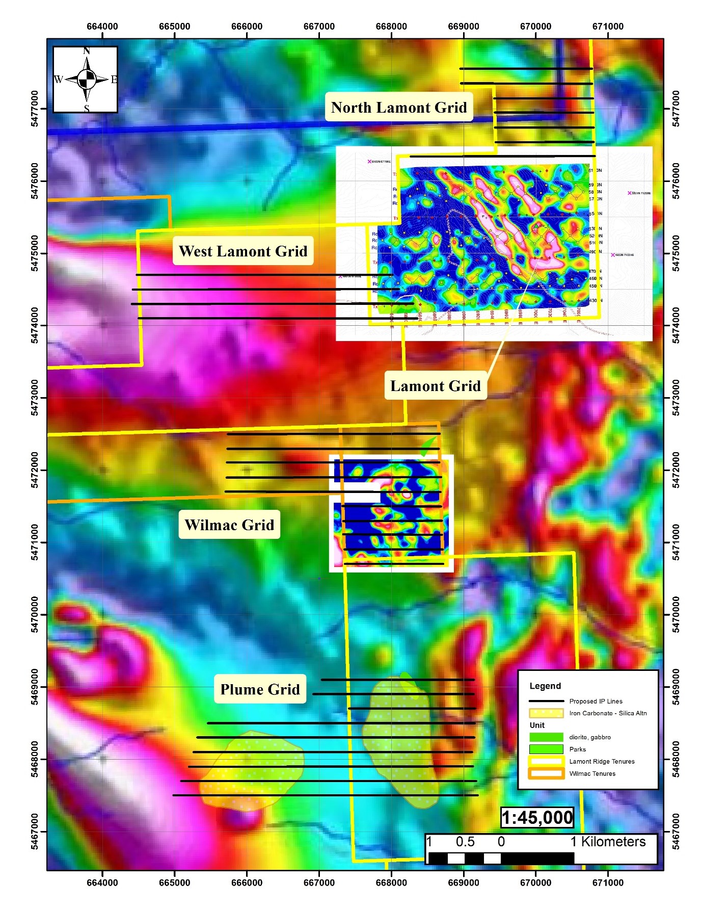
NovaRed Mining Inc. (CSE: NRED) has announced plans for a significant 2026 geophysical program to advance its Wilmac copper-gold project located in British Columbia's Quesnel porphyry belt, near Hudbay Minerals Inc.'s Copper Mountain Mine. The initiative, which has received "No Permit Required" authorizations, will involve four combined Induced Polarization/Audio-Magnetotelluric (IP/AMT) surveys across designated grids: North Lamont, West Lamont, Wilmac, and Plume.
The program aims to systematically increase geophysical coverage along Lamont Ridge. Key components include merging data from North and West Lamont grids with an existing Lamont survey, enhancing the understanding of the mineralized zone linked to the West Lamont Intrusive Complex. The completed Wilmac survey, left unfinished in November 2025 due to weather conditions, will be prioritized along with the newly proposed Plume survey, which targets significant iron carbonate-silica alteration zones.
CEO Brian Goss articulated that the 2026 program represents a pivotal step in evaluating the porphyry copper-gold potential of the area, particularly highlighting previous findings of chargeability anomalies corresponding with copper mineralization in surface samples. The detailed survey methodology will utilize multi-line acquisition sets to collect data efficiently and with minimal environmental impact.
The geophysical assessments are critical as the Wilmac project site, encompassing over 11,500 hectares, is interpreted to host valuable copper-gold porphyry occurrences similar to those found at the neighboring Copper Mountain Mine. With promising surface sample results already documented, the upcoming surveys are expected to further clarify the mineralization extent and guide potential future exploration efforts. NovaRed is strategically positioned to expand its understanding and exploration of this inground resource, bolstering its prospective value.
MWN-AI** Analysis
NovaRed Mining Inc. (CSE: NRED) has strategically positioned itself within the copper-gold market by advancing its Wilmac project through a comprehensive 2026 geophysical program. The company aims to leverage the promising geological setting of the Quesnel porphyry belt, closely located to the operational Copper Mountain Mine, to uncover additional mineralization opportunities.
Investors should pay close attention to the significance of the upcoming IP/AMT surveys spread across multiple grids—North Lamont, West Lamont, Wilmac, and Plume. The previous Lamont survey showed encouraging chargeability anomalies that correspond with surface copper mineralization, which bodes well for the potential success of these extensive operations. The dual-method approach of integrating induced polarization (IP) with audio-magnetotelluric (AMT) technology allows for comprehensive subsurface evaluation while mitigating operational disruptions through a minimally invasive survey method.
Financially, the support of the mining sector, combined with NovaRed's proactive measures such as obtaining the "No Permit Required" status, reflects positively on their operational timeline. The high-grade copper results identified previously in the Wilmac grid exemplify the area's potential, thereby enhancing the investment case for NovaRed. The geographical advantages, being close to established mining infrastructure and services, further bolster the project’s viability.
However, potential investors should remain cautious. The market is inherently volatile, influenced by commodity price fluctuations, operational risks, and regulatory hurdles regarding exploration activities. While the prospects look promising, as indicated by CEO Brian Goss's confidence in advancing the porphyry copper-gold potential, prudent investors should monitor the progress of the 2026 survey results and subsequent news releases for updated exploration insights before making investment decisions.
**MWN-AI Summary and Analysis is based on asking OpenAI to summarize and analyze this news release.
Vancouver, British Columbia--(Newsfile Corp. - March 11, 2026) - NovaRed Mining Inc. (CSE: NRED) (OTCQB: NREDF) ("NovaRed" or the "Company") announces that it has received "No Permit Required" authorizations for four combined Induced Polarization / Audio-Magnetotelluric ("IP/AMT") geophysical surveys on its 100%-optioned Wilmac copper-gold project ("Wilmac" or the "Project"), located within the Quesnel porphyry belt in the Similkameen Mining Division of British Columbia, approximately 10 kilometres west of Hudbay Minerals Inc.'s producing Copper Mountain Mine.
Proposed 2026 Program
The proposed 2026 program will include four geophysical surveys on four survey grids - North Lamont, West Lamont, Wilmac, and Plume - designed to systematically expand and infill the Company's geophysical coverage along Lamont Ridge (See Figure 1). Two of the four surveys (North Lamont and West Lamont) will be merged with the previously completed Lamont survey to create a single, integrated dataset covering the interpreted alteration and mineralized halo of the western portion of the West Lamont Intrusive Complex. A third survey will complete the Wilmac survey, which the Company partially completed in November 2025. The fourth survey, Plume, targets two separate and extensive iron carbonate-silica alteration zones approximately four kilometres to the south-southwest of the Wilmac survey.
The combined IP/AMT survey method provides both near-surface chargeability mapping (IP) and deep resistivity imaging to depths exceeding 1,500 metres (AMT), enabling the Company to evaluate porphyry copper-gold targets from surface to significant depth across the survey area.
"The 2026 geophysical program represents a significant step forward in systematically evaluating the porphyry copper-gold potential along Lamont Ridge," said Brian Goss, Chief Executive Officer. "Building on encouraging results from the initial Lamont survey - which identified chargeability anomalies spatially associated with anomalous copper mineralization in surface soil and rock samples - these four new grids will substantially expand our understanding of the scale and continuity of the mineralized system. Completion of the Wilmac grid, in which previous partial surveying identified a high-chargeability anomaly with significant volume at depth, is a particular priority."
Survey Design and Methodology
Each survey will employ multi-line acquisition sets comprising receiver lines and adjacent transmitting lines. Audio-Magnetotelluric data will be collected simultaneously with IP data by deploying high-sensitivity induction magnetometers during IP transmitter off-times. This dual-method approach yields complementary chargeability and resistivity models without requiring additional field mobilization. Longer lines will be surveyed in two overlapping segments to ensure full data coverage.
All surveys will be completed with minimal ground disturbance, limited to clearing undergrowth and deadfall along east-west oriented survey lines using hand tools.
Wilmac Grid (Priority)
The Wilmac grid covers three previously exposed trenches from which porphyry-style alteration and mineralization have been documented, including the WILMAC MINFILE occurrence. Analytical results for copper from 2023 surface samples ranged between 200 ppm (two values returning 1.235% and 1.670%), with an average of 6,390 ppm (0.639% copper) across nine samples. Mineralization is hosted in coarse-grained to pegmatitic hornblendite and is characterized by epidote alteration, chalcopyrite in quartz-carbonate veins with weakly to moderately developed stockworks, and possible AB-type porphyry veins (quartz-carbonate veins with sulphide cores).
The full Wilmac grid comprises 10 east-west lines totaling 21.5 line-km and covering approximately 371 hectares. An initial partial survey of 5 lines (totaling 9.95 line-km and covering approximately 195 hectares) was completed in the southern portion of the grid before being curtailed by snow cover and limited road access in early November 2025. That partial survey documented a high-chargeability anomaly spatially associated with the trench area, hosting porphyry-style alteration and high-grade mineralization, along with several similar anomalies of larger apparent volume at depth. Detailed results will be reported in a subsequent news release. Completion of the remaining five survey lines is a high priority for the 2026 field season.
North Lamont Grid
The proposed North Lamont grid is located north of the previously completed Lamont Grid and within the interpreted alteration and mineralized halo at the west end of the West Lamont Intrusive Complex. Two soil lines along forestry roads returned anomalous copper values. The proposed survey will consist of seven east-west survey lines between 1.36 and 2.53 km in length, totaling 14 line-km and covering approximately 179 hectares. Data will be merged with the existing Lamont dataset.
West Lamont Grid
The proposed West Lamont grid is located west of the previously completed Lamont Grid and is also within the interpreted alteration and mineralized halo at the west end of the West Lamont Intrusive Complex. The proposed survey will consist of four east-west survey lines between 3.52 and 3.85 km in length, totaling 14.94 line-km and covering approximately 222 hectares. Data will be merged with the North Lamont and existing Lamont datasets to create a single integrated survey.
Plume Grid
Located approximately 4.0 km south-southwest of the Wilmac grid, the Plume survey covers two relatively large areas of extensive iron carbonate-silica alteration mapped by Massey et al. (2008), interpreted to represent hydrothermal alteration driven by a large underlying intrusive complex. The proposed survey totals nine east-west lines between 1.73 km and 4.19 km in length, totalling approximately 29.53 line-km and covering approximately 539 hectares.
Background: Previous Lamont Grid Survey
A combined IP/AMT survey previously completed by the former operator on the Lamont Grid is interpreted to have documented an intrusive complex comprising two parent magmas. The eastern portion of the grid is characterized by high-chargeability anomalies near surface that correspond with anomalous surface soils and extend to significant depth as delineated by the AMT survey. The western portion is characterized by a high-resistivity anomaly associated with a lower level of surface soil anomalies. The two interpreted magmas interfinger, with comparatively narrow extensions toward surface that are interpreted as potential porphyries.
Wilmac Copper-Gold Project Overview
The Wilmac project comprises 11,504 hectares of mineral tenures located within the Quesnel porphyry belt in south-central British Columbia, southwest of Princeton. The Project is situated in a well-documented copper-gold porphyry belt and is interpreted to host potential for identification of one or more copper-gold alkalic porphyry occurrences similar in age and deposit type to those hosting the nearby Copper Mountain Mine, which currently hosts a Proven and Probable Mineral Reserve of 702 Mt at 0.24% Cu (source: Hudbay Minerals Inc.).
The Project is separated from the Copper Mountain camp by the regionally significant Boundary Fault. Saleken (2013) interpreted the geological setting west of the fault to be analogous to that of the Copper Mountain Intrusive Complex, but at a shallower level of erosional exposure, with numerous small, high-level diorite, gabbro and pyroxenite intrusions interpreted to represent the uppermost portions of an underlying intrusive complex.
Located immediately west of Highway 3, the Project is road-accessible within a well-established mining district with existing infrastructure and support services.
References
Massey, N.W.D., Vineham, J.M.S. and Oliver, S.L. (2008). Geology and Mineral Deposits of the Whipsaw Creek-Eastgate-Wolfe Creek Area, British Columbia (parts of NTS 092H/01W, 02E, 07E, 08W), 1:30,000 Scale, BCMEMPR Open File 2009-08.
Saleken, L. (2013). Compilation Report on the Tulameen Project Property, Whipsaw Target Area, Assessment Report 33,626A, filed January 31, 2013, 149 p.
Disclaimer
Readers are cautioned that the discussion of mineralization on adjacent or similar properties, including the Copper Mountain Mine, is not necessarily indicative of the mineralization or potential of the Lamont Ridge project. The Company has no interest in, or right to acquire any interest in, any such adjacent properties.
Qualified Person
The scientific and technical information in this news release has been reviewed and approved by Rick Walker, P.Geo., a Qualified Person as defined by National Instrument 43-101. Mr. Walker is not independent of the Company within the meaning of NI 43-101.
About NovaRed Mining Inc.
NovaRed Mining Inc. (CSE: NRED) (OTCQB: NREDF) is a mineral exploration company focused on the identification, acquisition, exploration and development of copper-gold porphyry projects in British Columbia. The Company's optioned Wilmac copper-gold project comprises 11,504 hectares located within the Quesnel porphyry belt in the Similkameen Mining Division, southwest of Princeton and approximately 10 kilometres west of Hudbay Minerals Inc.'s producing Copper Mountain Mine. For more information, visit novaredmining.com.
ON BEHALF OF NOVARED MINING INC.
Brian Goss
Chief Executive Officer
T: 775-340-2395
E: info@novaredmining.com
FORWARD-LOOKING INFORMATION
This news release contains "forward-looking information" within the meaning of applicable Canadian securities legislation, including statements regarding the planned 2026 geophysical programs, the timing, scope and completion of the proposed IP/AMT surveys on the North Lamont, West Lamont, Wilmac and Plume grids, the anticipated merging of survey datasets with previously completed data, and the Company's planned exploration activities on the Lamont Ridge project. Forward-looking information is based on a number of assumptions that, while considered reasonable by the Company at the date of this news release, are inherently subject to significant business, economic and competitive uncertainties and contingencies. Such assumptions include, without limitation, the availability of adequate funding to complete the proposed surveys, receipt of all necessary permits and authorizations, the availability of qualified personnel and geophysical contractors, favourable weather and field conditions, access to the Project area, and the accuracy of current geological interpretations.
Forward-looking information is subject to known and unknown risks, uncertainties and other factors that may cause actual results, performance or achievements to differ materially from those expressed or implied by such forward-looking information. Important risk factors include, but are not limited to: the continued availability of capital and financing; adverse weather or terrain conditions that may delay or prevent fieldwork; risks inherent in mineral exploration activities; changes in applicable laws and regulations; the ability to retain key personnel and contractors; litigation; failure of counterparties to perform their contractual obligations; and general economic, market or business conditions. Readers are cautioned not to place undue reliance on forward-looking information. The Company undertakes no obligation to update or revise any forward-looking information, except as required by applicable securities laws.
The Canadian Securities Exchange has not reviewed this press release and does not accept responsibility for the adequacy or accuracy of this news release.
Figure 1: Wilmac project map with proposed survey grids
To view an enhanced version of this graphic, please visit:
https://images.newsfilecorp.com/files/9977/288066_7ebb684e84d5c8da_002full.jpg
Location of the four proposed 2026 IP/AMT survey grids (North Lamont, West Lamont, Wilmac and Plume) along Lamont Ridge. The intense magenta-coloured magnetic anomaly at the left edge of the image corresponds to the West Lamont Intrusive Complex. Previously completed Lamont survey grid shown for reference.
To view the source version of this press release, please visit https://www.newsfilecorp.com/release/288066
FAQ**
How does the combined IP/AMT survey method utilized by NovaRed Mining I NREDF enhance the exploration of copper-gold mineralization at the Wilmac project compared to previous methods?
What specific challenges does NovaRed Mining I NREDF anticipate during the completion of the geophysical surveys, particularly with respect to weather conditions and access to the Project area?
Can you explain how the results from the initial Lamont survey influenced the planning of the 2026 geophysical program for the Wilmac project under NovaRed Mining I NREDF?
What measures are being taken by NovaRed Mining I NREDF to ensure minimal ground disturbance during the geophysical surveys, while still effectively mapping the mineralized systems within the four proposed grid areas?
**MWN-AI FAQ is based on asking OpenAI questions about NovaRed Mining I (OTC: NREDF).
NASDAQ: NREDF
NREDF Trading
25.0% G/L:
$1 Last:
1,000 Volume:
$1 Open:


